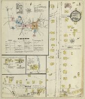
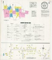
Sanborn fire insurance maps are a rich source of historic data on the urban built environment of North America during the 19th and early 20th centuries. The atlases were created for the purpose of underwriting fire insurance policies, which depended upon accurate and frequently-updated information about construction materials, municipal and transportation infrastructure, industrial and commercial landuse and more. The Yale University Library Map Department scanned its holdings of Sanborn fire insurance maps (consisting primarily of Connecticut towns) in order to make the maps more accessible.
Alternative Title:
Jan. 1889, Bethel, Conn.
Description:
"3 sheets.", Contains information on population, prevailing winds, water facilities and fire department., Includes index of streets and specials., Partial cadastral map., and SMLMAPL 766 B467 1889: Sheets disbound. "Triplicate" stamp on all sheets. Library of Congress copyright stamp on title sheet.
Subject (Geographic):
Bethel (Conn.)--Maps
Subject (Name):
Library of Congress Stamp
Subject (Topic):
Fire risk assessment--Connecticut--Bethel--Maps and Real property--Connecticut--Bethel--Maps
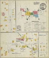
Sanborn fire insurance maps are a rich source of historic data on the urban built environment of North America during the 19th and early 20th centuries. The atlases were created for the purpose of underwriting fire insurance policies, which depended upon accurate and frequently-updated information about construction materials, municipal and transportation infrastructure, industrial and commercial landuse and more. The Yale University Library Map Department scanned its holdings of Sanborn fire insurance maps (consisting primarily of Connecticut towns) in order to make the maps more accessible.
Alternative Title:
Bethel, Conn. and July 1895, Bethel, Conn.
Description:
"(7983) 4 sheets.", Contains information on population, prevailing winds, water facilities and fire department., Includes index of streets and specials., Partial cadastral map., and SMLMAPL 766 B467 1895: Sheets disbound. "Triplicate" stamp on all sheets. Library of Congress copyright stamp on title sheet.
Subject (Geographic):
Bethel (Conn.)--Maps
Subject (Name):
Library of Congress Stamp
Subject (Topic):
Fire risk assessment--Connecticut--Berlin--Maps and Real property--Connecticut--Bethel--Maps
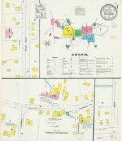
Sanborn fire insurance maps are a rich source of historic data on the urban built environment of North America during the 19th and early 20th centuries. The atlases were created for the purpose of underwriting fire insurance policies, which depended upon accurate and frequently-updated information about construction materials, municipal and transportation infrastructure, industrial and commercial landuse and more. The Yale University Library Map Department scanned its holdings of Sanborn fire insurance maps (consisting primarily of Connecticut towns) in order to make the maps more accessible.
Alternative Title:
Bethel, Conn. and Nov. 1901, Bethel, Conn.
Description:
"5 sheets 5100.", Contains information on population, prevailing winds, water facilities and fire department., Includes index of streets and specials., Partial cadastral map., and SMLMAPL 766 B467 1901: Sheets disbound. "Triplicate" stamp on all sheets. Library of Congress copyright stamp on title sheet.
Subject (Geographic):
Bethel (Conn.)--Maps
Subject (Name):
Library of Congress Stamp
Subject (Topic):
Fire risk assessment--Connecticut--Berlin--Maps and Real property--Connecticut--Bethel--Maps
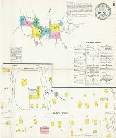
Sanborn fire insurance maps are a rich source of historic data on the urban built environment of North America during the 19th and early 20th centuries. The atlases were created for the purpose of underwriting fire insurance policies, which depended upon accurate and frequently-updated information about construction materials, municipal and transportation infrastructure, industrial and commercial landuse and more. The Yale University Library Map Department scanned its holdings of Sanborn fire insurance maps (consisting primarily of Connecticut towns) in order to make the maps more accessible.
Alternative Title:
Bethel, Conn. and May 1906, Bethel, Conn.
Description:
"5 sheets 8786.", Contains information on population, prevailing winds, water facilities and fire department., Includes index of streets and specials., Partial cadastral map., and SMLMAPL 766 B467 1906: Sheets disbound. "Triplicate" stamp on all sheets. Library of Congress copyright stamp on title sheet.
Subject (Geographic):
Bethel (Conn.)--Maps
Subject (Name):
Library of Congress Stamp
Subject (Topic):
Fire risk assessment--Connecticut--Berlin--Maps and Real property--Connecticut--Bethel--Maps
Sanborn fire insurance maps are a rich source of historic data on the urban built environment of North America during the 19th and early 20th centuries. The atlases were created for the purpose of underwriting fire insurance policies, which depended upon accurate and frequently-updated information about construction materials, municipal and transportation infrastructure, industrial and commercial landuse and more. The Yale University Library Map Department scanned its holdings of Sanborn fire insurance maps (consisting primarily of Connecticut towns) in order to make the maps more accessible.
Alternative Title:
Bethel, Connecticut and June 1912, Bethel, Conn.
Description:
"4966 (7 sheets).", Contains information on population, prevailing winds, water facilities and fire department., Includes index of streets and specials., Partial cadastral map., and SMLMAPL 766 B467 1912: Sheets disbound.
Subject (Geographic):
Bethel (Conn.)--Maps
Subject (Topic):
Fire risk assessment--Connecticut--Berlin--Maps and Real property--Connecticut--Bethel--Maps
Sanborn fire insurance maps are a rich source of historic data on the urban built environment of North America during the 19th and early 20th centuries. The atlases were created for the purpose of underwriting fire insurance policies, which depended upon accurate and frequently-updated information about construction materials, municipal and transportation infrastructure, industrial and commercial landuse and more. The Yale University Library Map Department scanned its holdings of Sanborn fire insurance maps (consisting primarily of Connecticut towns) in order to make the maps more accessible.
Alternative Title:
Bethel, Connecticut and Jan. 1927, Bethel, Conn.
Description:
"(2930) (10 sheets).", Contains information on population, prevailing winds, water facilities and fire department., Includes index of streets and specials., Partial cadastral map., and SMLMAPL 766 B467 1927: Sheets disbound.
Subject (Geographic):
Bethel (Conn.)--Maps
Subject (Topic):
Fire risk assessment--Connecticut--Bethel--Maps and Real property--Connecticut--Bethel--Maps
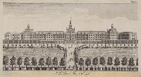
Title engraved below image., Place of publication derived from publisher's street address., Bottom edge trimmed., Below image at right: for the Beauties of England and Wales -- by E.W.B. dxt., In lower right margin: Proof., This electronic record is derived from historic data and may not reflect our current information. Review and updating of records is ongoing., and Temporary local Medical Library subject terms: Hospitals, Great Britain.
Toms, W. H. (William Henry), approximately 1700-1765, printmaker
Published / Created:
[not after 1765]
Call Number:
Print00787
Image Count:
1
Resource Type:
still image
Description:
Title from item., Date derived from printmaker's date of death., Place of publication derived from printmaker's nationality., In margin upper right: Page 660., and This electronic record is derived from historic data and may not reflect our current information. Review and updating of records is ongoing.
Publisher:
publisher not identified
Subject (Geographic):
Great Britain.
Subject (Name):
Bethlem Royal Hospital (London, England).
Subject (Topic):
Psychiatric hospitals, Hospitals, Gardens, and Pedestrians