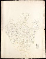
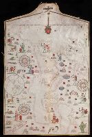
Coordinates not present on map and are approximated., Manuscript number on verso: 2170., and With key in lower right corner, possibly for population of towns and cities.
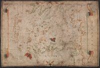
Colors: red, greens, and blues., Crucifix at top of map., Inset: The world., Joan Riezo figlo de mastro dominico [Olives] in missina año 1590., and Notes: gold ribbon along borders of map, missing from far right hand side.
Subject (Geographic):
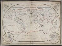
Europe--Maps--Early works to 1800 and Mediterranean Sea--Maps--Early works to 1800
Twentieth century forgery of a portlan chart with seaport names given for all coastlines; based on chart from the circle of Vesconte Maggiolo., Title devised by cataloger., Pen-and-ink in gold, brown, red, blue, and green., Contains eight compass roses., Decoration: armorial shields, city views with gilded banners, tents, and Madonna with child., Pasted on wood backing with modern brocade edging., and Coordinates not present on map and are approximated.
Subject (Geographic):
Mediterranean Sea, North Atlantic Ocean, Black Sea, Africa, West, Mediterranean Sea., North Atlantic Ocean., Black Sea., and Africa, West.