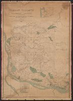
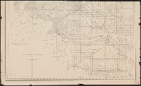
City of Vancouver., Map of Clark County, Washington Territory :, and Vancouver, Klickitat & Yakima R.R. and its proposed connections.
Description:
"Entered according to act of Congress A.D. 1888 by the Auditor of Clarke County W.T. in the office of the clerk of the U.S. district court for the district of Washington Territory, and a copy filed with the Librarian of Congress." and In bottom margin: Julius Bien & Co. photo-lith.
Publisher:
s.n.],
Subject (Geographic):
Clark County (Wash.)--Maps
Subject (Name):
Julius Bien & Co
Subject (Topic):
Real property--Washington (State)--Clark County--Maps
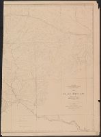
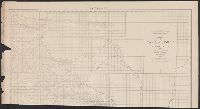
"Photolithographed preliminary sheet for the use of the parties in the field and subject to revision.", Library's copy has separated into 2 sheets (each 82 x 60 cm.), at center fold., and Relief shown by contours and spot heights.
Publisher:
Northern Transcontinental Survey?],
Subject (Geographic):
Crazy Mountains Region (Mont.)--Maps, Topographic
Subject (Name):
Julius Bien & Co and Northern Transcontinental Survey. Topographical Dept
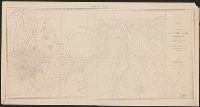
In upper left margin: Eleventh Census of the United States., Includes text and table of railroads' statutory authorizations., Prime meridians: Washington and Greenwich., and Relief indicated by hachures.
In bottom margin: Photolithographed preliminary sheet for the use of the parties in the field and subject to revision., In top margin: Northe, Library's copy separated into two sheets (59 x 58 cm. and 59 x 55 cm.)., and Relief shown by contours and spot heights.
Publisher:
Northern Transcontinental Survey?],
Subject (Geographic):
Judith River Watershed (Mont.)--Maps, Topographic
Subject (Name):
Julius Bien & Co, Northern Transcontinental Survey. Topographical Dept, and Owen, F. D
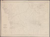
In bottom margin: Photolithographed preliminary sheet for the use of the parties in the field and subject to revision., In top margin: Souther, Library's copy separated into two sheets (76 x 43 cm. and 76 x 59 cm.), and Relief shown by contours and spot heights.
Publisher:
Northern Transcontinental Survey?],
Subject (Geographic):
Judith River Watershed (Mont.)--Maps, Topographic
Subject (Name):
Julius Bien & Co and Northern Transcontinental Survey. Topographical Dept
Map of Yakima Region, Washington Ter., western sheet
Description:
"Photolithographed preliminary sheet for the use of the parties in the field, and subject to revision.", In top margin: Western sheet., and Relief shown by contours and spot heights.
Publisher:
Northern Transcontinental Survey?],
Subject (Geographic):
Yakima River Valley (Wash.)--Maps, Topographic
Subject (Name):
Goode, Richard Urquhart, 1858-1903, Julius Bien & Co, Northern Transcontinental Survey, Owen, F. D, and Tweedy, Frank, 1854-1937
Map of Yakima Region, Washington Ter., eastern sheet
Description:
"Photolithographed preliminary sheet for the use of the parties in the field, and subject to revision.", "There is a slight discordance in projecting the U.S. Land Survey upon this map. A part of the S.W. corner is taken from the U.S. Land Office plats.", and n top margin: Eastern sheet.
Publisher:
Northern Transcontinental Survey?],
Subject (Geographic):
Yakima River Valley (Wash.)--Maps, Topographic
Subject (Name):
Goode, Richard Urquhart, 1858-1903, Julius Bien & Co, Northern Transcontinental Survey, Owen, F. D, and Tweedy, Frank, 1854-1937