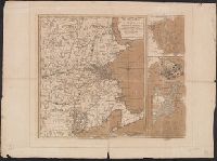
Mer, Printed on sheet with 3 maps total: [1.] The seat of war in New England -- [2.] Plan of Boston Harbour -- [3.] Plan of the town of Boston with the attack on Bunkers-Hill in the peninsula of Charlestown, the 17th of June 1775., and Relief shown by hachures.
Publisher:
Printed for R. Sayer & J. Bennett, No. 53 Fleet Street, as the act directs,
Subject (Geographic):
Boston (Mass.)--History--Siege, 1775-1776--Maps--Early works to 1800, New England--History--Revolution, 1775-1783--Maps--Early works to 1800, New England--Maps--Early works to 1800, and United States--History--Revolution, 1775
"Supplement to all dailies published by Manila Shinbun-sha"., English, Japanese., Imperfect: Mutilated, with some loss of text., Map on verso: Greater East Asia war and brilliant achievements., and Tables of Allied and Axis statistics on verso.
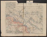
Copious ms. notes on maps. Accompanied by: 1) TLS from Alexander O. Vietor to Dr. Albrecht Goetze dated May 1, and III. Btl. J.R. Jaud. 18.3.18, 1:10,000 -- Regl. Jaud 21.3.18, 1:10,000 -- Remenauville, 1:2,500 -- 5. Cormicy, 1:25,000.
Subject (Geographic):
World War, 1914-1918--Battlefields--France--Lorraine--Maps and World War, 1914-1918--Personal narratives, German
Subject (Name):
Götze, Albrecht,--1897-1971 and Götze, Albrecht,--1897-1971--Ownership
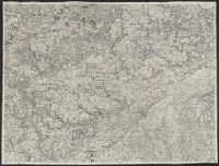
"Ed. Nov. 10, 1863"--Lower right corner., Mounted on linen. Manuscript markings show positions of 2,3,5,6 Corps surrounding Court House., Relief shown by hachures., and Title supplied by cataloger.