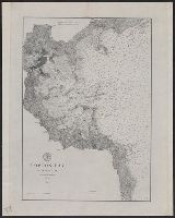
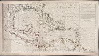
Below title in cartouche: "Met privilegio voor 15 iaaren ao 1687.", Depths shown by soundings., Dutch and French., Inset map: Le partie du Carolina grand point., and Sheet measures 44.3 x 56.7 cm. Cross Collection no. 220.
Publisher:
s.n.],
Subject (Geographic):
Atlantic Coast (South Atlantic States)--Nautical charts--Early works to 1800 and South Carolina--Nautical charts--Early works to 1800
Subject (Topic):
Nautical charts--Atlantic Coast (South Atlantic States)--Early works to 1800 and Nautical charts--South Carolina--Early works to 1800
Peirce, Benjamin, 1809-1880 United States Coast Survey
Published / Created:
1869
Call Number:
846cea Or4 1869
Container / Volume:
BRBL_00623
Image Count:
1
Resource Type:
Maps, Atlases & Globes
Description:
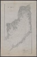
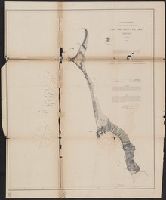
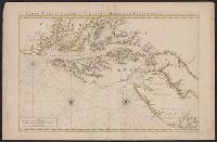
In upper left margin: No. 16., Includes notes., Relief shown by hachures. Depths shown by soundings., and Removed from: United States Coast Survey, Annual report of the superintendent of the Coast Survey (1869).
Publisher:
U.S. Coast Survey,
Subject (Geographic):
Blanco, Cape (Or.)--Maps and Port Orford (Or.)--Maps
Subject (Name):
United States Coast Survey. Annual report of the superintendent of the Coast Survey. 1869
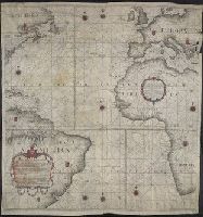
Below lower left margin: A.I.M. Faria. esc. 2., Contains nine compass roses., Copy printed on 4 sheets of vellum, joined together to form 1 sheet. Imperfect: top right edge mutilated. Hand-colored., Covers also continent of Europe as far east as Greece, Africa entire continent from north to south as far east as Libya, North America as far south west as Virginia, part of Cuba, Jamaica, West Indies, and South America as far south as far south as Buenos Aires., Dedication: "Offerecida ao Illustrissimo e Excellentisimo Senhor Luis de Vasconcellos e Souza, do Conselho de Sua Magestade Fidelissima, Vice Reij e Capitaõ General de Mar, e Terra do Estado do Brazil.", Each country and its imperial provinces demarcated with coat-of-arms., Historiated title cartouche., Includes foliated cartouche with: Declaracao Preliminar., No relief shown., Prime meridians: London, Paris, and Ferro; coordinates converted by cataloger to express longitude based on Greenwich prime meridian., and Shows continents, names of countries, coastal towns, cities, and islands.
Publisher:
[Simão Antônio da Rosa Pinheiro],
Subject (Geographic):
Atlantic Ocean--Maps, Manuscript--Early works to 1800
Subject (Name):
Faria, A. I. M.
Subject (Topic):
Nautical charts--Atlantic Ocean--Early works to 1800.
"4 e. feuille.", "No. 5" in lower right corner., Prime meridian: Paris., Relief shown pictorially. Depths shown by soundings., Shows English ownership of Florida., and Stamped no. "107" and title "Golfe du Mexique" on verso. Cross Collection no. 246.
Publisher:
Sur ley Quay de la Megisserie prés le Pont Neuf ...,
Subject (Geographic):
Caribbean Area--Maps--Early works to 1800
Subject (Name):
Buache, Philippe, 1700-1773. Atlas géographique et universel, L'Isle, Guillaume de, 1675-1726. Atlas géographique et universel, and Popple, Henry, -1743
Subject (Topic):
Nautical charts--Caribbean Area--Early works to 1800
Hand col. Mounted on linen. Sheet measures 65 x 49 cm. Ms. n, Has watermarks., Includes index and ill., Oriented with north to the bottom., Relief shown by hachures. Depths shown by soundings., and Shows fortifications and coastal defenses in the Gibraltar region.
Publisher:
Chez Basset, rue St. Jacques, au coin de delle des Mathurins,
Subject (Geographic):
Gibraltar, Bay of (Spain)--Maps--Early works to 1800
Subject (Name):
Coquart, A
Subject (Topic):
Coast defenses--Spain--Gibraltar, Bay of--Maps--Early works to 1800 and Fortification--Spain--Gibraltar, Bay of--Maps--Early works to 1800
Neptune françois, ou, Atlas nouveau des cartes marines.
Description:
Appears in: Le Neptune françois, ou, Atlas nouveau des cartes marines, various eds., Covers coasts of Virginia, Maryland, Delaware, New, Described in Coolie Verner's Printed maps of Virginia, 1590-1800, p. 402., Nautical chart., and Oriented with north to right.
Publisher:
Chez P. Mortier,
Subject (Geographic):
Middle Atlantic States--Maps--Early works to 1800
Subject (Name):
Mortier, Pierre
Subject (Topic):
Coasts, Coasts--Delaware--Maps--Early works to 1800, Coasts--Maryland--Maps--Early works to 1800, Coasts--New Jersey--Maps--Early works to 1800, and Nautical charts--Chesapeake Bay (Md. and Va.)--Early works to 1800