Skip to search
Skip to main content
Skip to first result
Search
You Searched For
Resource Type
Maps, Atlases & Globes
Publication Place
London :
New Search
Search Results
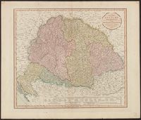
Published / Created:
1811
Call Number:
43 1811
Container / Volume:
BRBL_00250
Image Count:
1
Resource Type:
Maps, Atlases & Globes
Publisher:
J. Cary,
Subject (Geographic):
Hungary--Maps
Found in:
Beinecke Rare Book and Manuscript Library > A new map of Hungary ... / by John Cary, engraver.
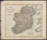
Published / Created:
1799
Call Number:
327 1799
Container / Volume:
BRBL_00073
Image Count:
1
Resource Type:
Maps, Atlases & Globes
Publisher:
J. Cary,
Subject (Geographic):
Ireland--Maps--Early works to 1800
Found in:
Beinecke Rare Book and Manuscript Library > A new map of Ireland ... by John Cary, Engraver.
Published / Created:
1811
Call Number:
327 1811
Container / Volume:
BRBL_00073
Image Count:
1
Resource Type:
Maps, Atlases & Globes
Description:
Preliminary record.
Publisher:
J. Cary,
Subject (Geographic):
Ireland--Maps
Found in:
Beinecke Rare Book and Manuscript Library > A new map of Ireland ... by John Cary, Engraver.
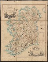
Published / Created:
1793
Call Number:
327 1793
Container / Volume:
BRBL_00072
Image Count:
1
Resource Type:
Maps, Atlases & Globes
Publisher:
W. Faden,
Subject (Geographic):
Ireland--Maps--Early works to 1800
Found in:
Beinecke Rare Book and Manuscript Library > A new map of Ireland ... distances between the Towns & Stages, marked in miles and furlongs ... by Alexander Taylor ... Royal Engineers.
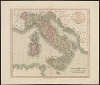
Published / Created:
1799
Call Number:
40 1799
Container / Volume:
BRBL_00198
Image Count:
1
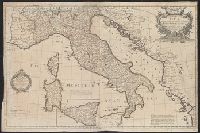
Resource Type:
Maps, Atlases & Globes
Publisher:
Publish'd by J. Cary ... ,
Subject (Geographic):
Italy--Maps--Early works to 1800
Found in:
Beinecke Rare Book and Manuscript Library > A new map of Italy ... / by John Cary, engraver.
Published / Created:
[ca. 1760]
Call Number:
40 1780C
Container / Volume:
BRBL_00198
Image Count:
2
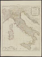
Resource Type:
Maps, Atlases & Globes
Description:
Dedication under coat of arms inscribed Honi Soit Qui Mal y Pense: To His Most Sacred Majesty George by the grace of God King of Great Britain, France and Ireland &c. this map is most humbly dedicated by His Majesty's most loyal & obedient subject and ser
Publisher:
Robt. Sayer at the Golden Buck in Fleet Street,
Subject (Geographic):
Italy--Administrative and political divisions--Maps--Early works to 1800 and Italy--Maps--Early works to 1800
Subject (Name):
Overton, Henry, 1675 or 6-1751 and Sayer, Robert, 1725-1794
Found in:
Beinecke Rare Book and Manuscript Library > A new map of Italy : distinguishing all the sovereignties in it whether states, kingdoms, dutchies, principalities, republicks &c. with the post roads, & many remarks not extant in any map, according to the newest and most exact observations.
Creator:
Published / Created:
1794
Call Number:
40 1794
Container / Volume:
BRBL_00198
Image Count:
1
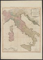
Resource Type:
Maps, Atlases & Globes
Alternative Title:
Carte de l'Italie et de touts ses routes de poste, à l'usage de voyageurs
Description:
Appears in Laurie and Whittle, A new universal atlas, 1796, plate 16., Horizontal fold at middle of map and guard on verso., Includ, Relief shown pictorially., and Sheet measures 72 x 54 cm. Stamp on verso: Karpinski-von Wieser Map Collection. dgvmp2008.
Publisher:
Laurie & Whittle,
Subject (Geographic):
Italy--Maps--Early works to 1800
Subject (Name):
Anville, Jean Baptiste Bourguignon d', 1697-1782 and Robert Laurie and James Whittle
Found in:
Beinecke Rare Book and Manuscript Library > A new map of Italy with the islands of Sicily, Sardinia & Corsica / from Monsr. d'Anville: to which have been added the post roads and several other improvements.
Published / Created:
1790
Call Number:
40 1790
Container / Volume:
BRBL_00198
Image Count:
1
Resource Type:
Maps, Atlases & Globes
Publisher:
Printed for Robt. Sayer ... ,
Subject (Geographic):
Italy--Maps--Early works to 1800
Found in:
Beinecke Rare Book and Manuscript Library > A new map of Italy, with the islands of Sicily, Sardinia & Corsica / from Monsr. d'Anville ...
Published / Created:
1720
Call Number:
32 L84 1720
Container / Volume:
BRBL_00048
Image Count:
1
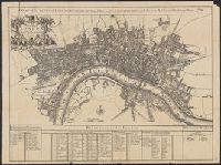
Resource Type:
Maps, Atlases & Globes
Description:
A plan of the City's of London, Westminster and Borough of Southwark; with the new Additional Buildings Anno. 1720., E. Weller, litho. London, Cassel & Co., [1910?], and Index to names on map in margin.
Publisher:
Cassell & Company,
Subject (Geographic):
London (England)--Maps--Early works to 1800
Found in:
Beinecke Rare Book and Manuscript Library > A new map of London ... 1720 Revised by Ino. Senex. S. Parker Delin. et sculpt.
Published / Created:
[1690?]
Call Number:
755 1690
Container / Volume:
BRBL_00424
Image Count:
1
Resource Type:
Maps, Atlases & Globes
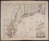
Description:
Inset: Environs of New York City. and Negative on file.
Publisher:
Philip Lea,
Subject (Geographic):
East (U.S.)--Maps--Early works to 1800
Found in:
Beinecke Rare Book and Manuscript Library > A new map of New England, New York, New Jarsey, Pensilvania, Maryland and Virginia.
Branch:v1.61.6 ,Deployed:2024-06-12T09:55:33-04:00