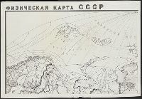
"Administrativnoe delenie na 10 i︠a︡nvari︠a︡ 1930 g.", "Glavlit No. A-59183.", "Goznak. Mytnai︠a︡, 17.", "Главлит No. A-59183.", "Гознак. Мытная, 17.", and Административное деление на 10 января 1930 г.
Publisher:
Izdanie Kartoizdatelʹstva NKVD RSFSR, and Издание Картоиздательства НКВД РСФСР,
Karpinskiĭ, A. P. (Aleksandr Petrovich), 1846-1936
Published / Created:
1884
Call Number:
352ca Ur1 1884
Container / Volume:
BRBL_00109
Image Count:
3
Resource Type:
Maps, Atlases & Globes
Alternative Title:
Geologische Karte des Ostabhanges des Urals
Description:
Includes 2 inset maps: "Geologicheskai︠a︡ karta okrestnosteĭ S. Smolina" and "Geologicheskai︠a︡ karta dachi kamenskago zavoda.", Longitudinal coordinates shown on map are based on Pulkova., and Russian and German.
Egorova, L. N Soviet Union. Glavnoe upravlenie geodezii i kartografii
Published / Created:
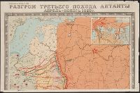
1949
Call Number:
35hc 1922
Container / Volume:
BRBL_00103
Image Count:
4
Resource Type:
Maps, Atlases & Globes
Description:
"G-116.", Relief shown by shading., and Shows Soviet, White and Allied troop movements.
Publisher:
Glavnoe upravlenie geodezii i kartografii,
Subject (Geographic):
Russia (Territory under White armies, 1918-1920)--History--Maps, Soviet Union--History--Allied intervention, 1918-1920--Maps, and Soviet Union--History--Revolution, 1917-1921--Maps
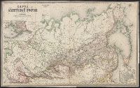
From A.A. Ilʹin's Uchebnyĭ geograficheskiĭ atlas (1885)., From A.A. Ilʹin's Учебный географический атласъ (1885)., Prime meridians: Greenwich and Pulkovo., and Relief shown by hachures.
Subject (Geographic):
Siberia (Russia)--Maps
Subject (Name):
Ilʹin, A. A. (Alekseĭ Alekseevich), 1858-1942. Uchebnyĭ geograficheskiĭ atlas, Kartograficheskoe zavedenīe A. Ilʹina, publisher, Ильинъ, А. А. (Алексей Алексеевич), 1858-1942. Учебный географический атласъ, and Картографич
Russia. Generalʹnyĭ shtab Россия. Генеральный штаб
Call Number:
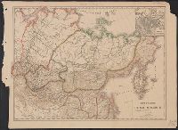
54 1864
Container / Volume:
BRBL_00290
Image Count:
1
Resource Type:
Maps, Atlases & Globes
Alternative Title:
[Saint Peterburg] : Хроматографическое и Металлографическое Заведения Полторацкого Ильина и Ко., Karta vladi︠e︡nīĭ Rossīĭsko Amerikanskoĭ Kompanīi., К, and Карта Азіятской Россіи / составлена по новѣйшим свѣдѣніям генерального Штаба подполковником Ильиным.
Description:
"Dozvoleno T︠s︡enz, "Дозволено Цензурой C. Петербург 12 Маія 1864.", Includes inset map "Karta vladi︠e︡nīĭ Rossīĭsko Amerikanskoĭ Kompanīi" (scale 1:21,000,000)., and Includes inset map "Карта владѣний Российско Американской Компаніи" (scale 1:21,000,000).