"Cum privilegio Ordinum Hollandiae et Westfrisiae.", Bar scales in "Milliaria Germanica communia," "Milliaria Hispanica communia," and "Milliaria Gallica communia.", Cross Collection no. 342., Relief shown pictorially., and Title in ms. on verso with ms. no.: 148.
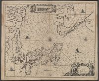
"R. de Hooghe f.", Appeared in Valk and Schenk's Atlantis sylloge compendiosa, ca. 1702., Backed with paper. Ms. no. "62" in lower right-hand corner. Sheet measures 53.6 x 62.8 cm. No. 57 of 87 maps bound together., Bar scales given in "milliaria Germanica" and "milliaria Gallica.", Prime meridian: Ferro., Relief shown pictorially., and Watermark.
Publisher:
By Gerard Valk op den Dam in de Wackere Hont, t'Amsterdam met privilegie van de Ed. Gr. Moog. Heeren staaten van Holl. en West Vriesland,
Subject (Geographic):
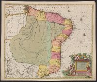
Aquitaine (France)--Maps--Early works to 1800.
Subject (Name):
Hooghe, Romeyn de, 1645-1708, engraver., Schenk, Peter, 1660-1718 or 1719. Atlantis sylloge compendiosa., Valck, G. (Gerard), 1651 or 1652-1726. Atlantis sylloge compendiosa., and Valck, Leonard, 1675-1746.
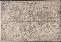
Orbis terrarvm typvs de integro multis in locis emendatus
Description:
Copy 1: Imperfect: chipped along folds, with some loss of text. Backed with linen. and Double hemispherical map of the world, with 2 smaller celestial hemispheres. New Guinea shown as part of southern continent called Magallanica. The two hemispheres are surr
Orbis terrarvm typvs de integro multis in locis emendatus
Description:
Copy 2: Imperfect: chipped along folds, with some loss of text. Backed with paper. and Double hemispherical map of the world, with 2 smaller celestial hemispheres. New Guinea shown as part of southern continent called Magallanica. The two hemispheres are surr
Appears in Jansson's historical atlas editions from 1652-1684 and in his Accuratissima orbis antiqui delineatio. From 1653 on, this work is known under the name of Hornius, who wrote the text and compiled all the maps for the atlases--(Koeman-Krogt. 1:601-1:607)., Coordinates not present on map and are approximated., Inset: Itinera et mansiones deserti., Map indexed with grid lines and alphabet letters A-H at top., Oriented with north toward the left., Relief shown pictorially., Shows greater part of the Tribe of Judah, with Biblical illustrations., and Watermark. Manuscript number in upper left corner: 48. No. 5 of 6 maps housed together.
Publisher:
[Jan Jansson],
Subject (Geographic):
Palestine--History--To 70 A.D.--Maps--Early works to 1800. and Palestine--Maps--Early works to 1800.
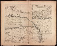
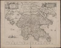
Coordinates not present on map and are approximated., Includes four bar scales., Relief shown pictorially., Verso blank., and Watermark. Manuscript number in upper left corner: 31. Manuscript annotation at top: Thebo.
Publisher:
[Jan Jansson],
Subject (Geographic):
Peloponnesus (Greece : Peninsula)--Maps--Early works to 1800.
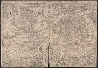
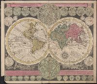
Vlakke aard-kloot met het beide hemelsch half-rond, of de onder scheidene verbeelding van de land-water-waereld
Description:
"De Warmoes Straat sub signo R. Visschers Athlas"., Cross collection no. 29., Double hemispherical world map showing routes of explorers including Magellan, Dampier, Tasman and Chaumont., Includes twenty-six smaller astronomical diagrams and hemispheres of the world, two larger celestial hemispheres and textual commentary., and Relief shown pictorially.
Publisher:
Ex officina Petri Schenkii ...,
Subject (Geographic):
Australia--Maps--Early works to 1800
Subject (Name):
Schenk, Peter, 1660-1718 or 1719. Atlas contractus