Skip to search
Skip to main content
Skip to first result
Search
You Searched For
Format
cartographic
Publication Place
Paris :
New Search
Search Results
Creator:
Published / Created:
[1917]
Call Number:
38gmb P21 1907
Container / Volume:
BRBL_00171
Image Count:
2
Resource Type:
Maps, Atlases & Globes
Alternative Title:
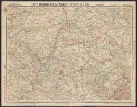
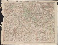
Environs de Paris : and Nouvelle carte de France à l'usage des cyclistes et automobiles.
Description:
"11-17"--Lower right., In French., and Sheet index on panel.
Publisher:
Cartes Taride,
Subject (Geographic):
France, Northern--Maps
Subject (Name):
Cartes Taride (Firm)
Subject (Topic):
Bicycle trails--France, Northern--Maps and Roads--France, Northern--Maps
Found in:
Beinecke Rare Book and Manuscript Library > Carte automobilistes & cyclistes : environs de Paris, nord-ouest / A. Taride, editeur.
Creator:
Published / Created:
[1907]
Call Number:
38gmb P21 1907A
Container / Volume:
BRBL_00171
Image Count:
1
Resource Type:
Maps, Atlases & Globes
Alternative Title:
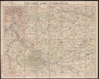
Environs de Paris :
Description:
"08-07"--Lower right., In French., and Sheet index on panel.
Publisher:
Cartes Taride,
Subject (Geographic):
France, Southern--Maps
Subject (Name):
Cartes Taride (Firm)
Subject (Topic):
Bicycle trails--France, Southern--Maps and Roads--France, Southern--Maps
Found in:
Beinecke Rare Book and Manuscript Library > Carte cycliste et automobile des environs de Paris : à l'échelle du 1/100.000e, sud-est / A. Taride, editeur.
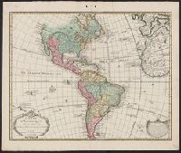
Creator:
Published / Created:
1745?]
Call Number:
70 1745
Container / Volume:
BRBL_00355
Image Count:
1
Resource Type:
Maps, Atlases & Globes
Description:
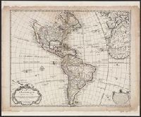
In cartouche: À Paris, chez l'Auteur sur le Quay de l'Horlage avec privilège, 1722., In lower right margin: Ph. Buache, P.G.d.R: d.l'A.d.S. Gendre de l'Auteur avec privilège du 30 Av. 1745., Includes text., Prime meridian: Ferro., and Relief shown pictorially.
Publisher:
[Ph. Buache?,
Subject (Geographic):
America--Maps--Early works to 1800
Found in:
Beinecke Rare Book and Manuscript Library > Carte d'Amerique : dressée pour l'usage du Roy / par Guillaume Delisle, premier Géographe de sa Majesté de l'Académie Royale des Sciences.
Creator:
Published / Created:
[between 1784 and 1795?]
Call Number:
70 1795A
Container / Volume:
BRBL_00357
Image Count:
1
Resource Type:
Maps, Atlases & Globes
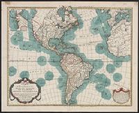
Description:
Includes text and inset of "Supplément à la partie nord-ouest de l'Amérique, d'après les découvertes du Capitaine Cook." and Library's copy annotated in pencil, crossing out parts of legend, and with annotations on verso conjecturing that it is the m
Publisher:
Dezauche ;
Subject (Geographic):
America--Maps--Early works to 1800
Subject (Name):
Buache, Philippe, 1700-1773, Dezauche, J, and Streeter, Thomas W.--(Thomas Winthrop),--1883-1965 $x Ownership
Found in:
Beinecke Rare Book and Manuscript Library > Carte d'Amérique : dressée pour l'instruction, par Guil. Delisle et Phil. Buache, premiers géographes de l'Académie des Sciences ; nouvellement revue, augmentée et assujetie aux nvles observations astronomiques de mrs. de l'Académie des Sciences, pa
Branch:v1.61.8 ,Deployed:2024-06-20T11:15:15-04:00