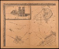
Grand plan de Paris et de ses environs, Paris et ses environs., Réproductions d'anciens plans de Paris, and Réproductions d'anciens plans de Paris ; [7].
Description:
"En vente, chez le sieur de Richesource, en place Daufine, à la Renomé. Publiée en 9 feuilles, accompagné d'une notice de M.A. Bonnardot"--Cover., "Gravé par François de La Pointe.", Accompanied by text: Grand plan de Jouvin de Rochefort, publié vers 1690 : extrait des Etudes archéologiques sur les anciens plans de Paris / Alfred Bonnardot., Cover title., Facsimile., Includes text: Grand plan de Jouvin de Rochefort, retouché en 1714 : extrait des Etudes archéologiques sur les anciens plans de Paris / Alfred Bonnardot., Includes view "Nostre Dame"., Inset map: Paris et ses environs., and Original scale information: "seize cens pas communs" ; "deux lieues communes de France"
Publisher:
A. Taride,
Subject (Geographic):
France--Paris, France--Paris Region, Paris (France)--Maps--Early works to 1800--Facsimiles., and Paris Region (France)--Maps.
Subject (Name):
Bonnardot, A. (Alfred). Grand plan de Jouvin de Rochefort., Cartes Taride (Firm), and La Pointe, François de.
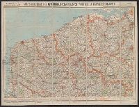
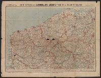
Carte routière pour automobilistes et cyclistes, Carte Taride, Cartes Taride pour automobilistes et cyclistes, and Nouvelle carte de France à l'usage des cyclistes et automobilistes
Description:
Also shows adjacent areas of Germany, Belgium, the Netherlands, Luxembourg, Switzerland, Italy, and Spain., Coverage complete in 34 sheets. Copy 3 incomplete., Each sheet separately numbered and titled: e.g., no. 3, Environs de Paris, section nord-est ; no. 27, Les bords du Rhin, Mayence à Strasbourg., Relief shown by shading and spot heights., and Some sheets dated in lower right corner, e.g., 5-18.
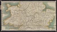
Veue et perspective de la ville de Londre, Westminster et Parc St. Jacques and View of London and Westminster by John Kip, circa 1710-1720
Description:
"To Her Royal Highness Wilhelmina Carolina, the most illustrious Princess of Wales, this prospect of London, Westminster & St. James's Park is most humbly dedicated by John Kip.", In lower margin: Key to selected buildings or places of interest,, and Panorama.
Publisher:
London Topographical Society,
Subject (Geographic):
London (England)--Pictorial works--Early works to 1800--Facsimiles
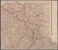
Carte routière pour automobilistes et cyclistes, Carte Taride, Cartes Taride pour automobilistes et cyclistes, and Nouvelle carte de France à l'usage des cyclistes et automobilistes
Description:
Also shows adjacent areas of Germany, Belgium, the Netherlands, Luxembourg, Switzerland, Italy, and Spain., Coverage complete in 34 sheets. Copy 2 incomplete., Each sheet separately numbered and titled: e.g., no. 3, Environs de Paris, section nord-est ; no. 27, Les bords du Rhin, Mayence à Strasbourg., Relief shown by shading and spot heights., and Some sheets dated in lower right corner, e.g., 5-18.