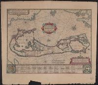
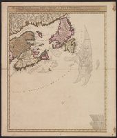
Insulae vel Insularum quas Bermudes vocant, descriptio, Insularum Bermudes, and Mappa Aestivarvm Insularum
Description:
At bottom of map "Nomina fortunae bona Submittentium in quaestus Virginiani alea A.⁰ 1622 ...", Cross Collection no. 65., From Jansonius's and Hondius's Atlas novus ... Amstelodami : Apud Ionnem Ianssonium & Henricum Hondium, 1638., and Signature 4Q on verso.
Publisher:
Apud Henricum Hondium,
Subject (Geographic):
Bermuda Islands--Maps--Early works to 1800
Subject (Name):
Hondius, Hendrik, 1597-1651. Atlas novus and Jansson, Jan, 1588-1664. Atlas novus
Mappa Aestivarvm insularum, alias Barmvdas dictarum
Description:
Below map, list of proprietors in 12 columns flanked by coats-of-arms., Borders are hand colored., and Not hand colored. With watermark. Sheet measures 46 x 55 cm.
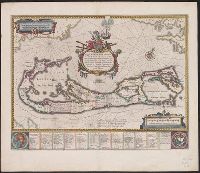
Mappa Aestivarvm insularum, alias Barmvdas dictarum
Description:
Based on Speed's map of 1626 but with new decorations., Below map, list of proprietors in 12 columns with arms of England and Bermuda., From the author's Theatre du monde ou nouvel atlas., Latin and English text on recto and French text on verso., Signature on verso: G., and Title on verso: L'Isle de Barmudas, avec ses voysines.
Publisher:
[Guillaume et Iean Blaeu,
Subject (Geographic):
Bermuda Islands--Maps--Early works to 1800
Subject (Name):
Blaeu, Joan, 1596-1673. Theatrum orbis terrarum. French and Blaeu, Willem Janszoon, 1571-1638. Theatrum orbis terrarum. French
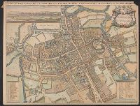
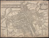
Nova & accuratissima celeberrimæ universitatis civitatisque Oxoniensis scenographia
Description:
"Cum privil. S.R.M. 1675"., Copy 2: Imperfect. Hand col. Sheet measures 43 x 56 cm., Dedication to Henry Compton., From Loggan's Oxonia illustrata ... [Oxford : The Sheldonian Theatre, 1675]., Index of academic and civic buildings., and Inset view: "Oxoniæ prospec
Nova & accuratissima celeberrimæ universitatis civitatisque Oxoniensis scenographia
Description:
"Cum privil. S.R.M. 1675"., Copy 1: Sheet measures 42 x 54 cm. Verso: Stamped "Bibliotheca Bodleiana", "Madan Collection"., Dedication to Henry Compton., From Loggan's Oxonia illustrata ... [Oxford : The Sheldonian Theatre, 1675]., and Index of academic and civic
Carte nouvelle contenant la partie d'Amerique la plus septentrionale : ou sont exactement dêcrites les provinces suivantes comme le Canada ou Nouvelle France, la Nouvelle Ecosse, la Nouvelle Angleterre, les Nouveaux Paı̈s Bas, la Pensylvanie, la Virginie
Description:
"Cum privilegio ordinum generalium foederati Belgii.", Appears in some eds. of the author's Atlas minor sive geographia compendiosa., Library copy incomplete, Atlantic Canada sheet only; damaged in upper left., and Relief shown pictorially. Depths shown by sound
Publisher:
Nicolao Visscher,
Subject (Geographic):
Atlantic Provinces--Maps--Early works to 1800 and North America--Maps--Early works to 1800
Subject (Name):
Anse, Luggert van, fl. 1690-1716, engraver and Visscher, Nicolaes, 1649-1702. Atlas minor sive geographia compendiosa
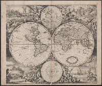
Imperfect: mutilated along folds, with some loss of text. Cross collection no. 24., Includes ill. and ancillary maps of north and south polar regions., and Relief shown pictorially.
Homann Erben (Firm) Homann, Johann Baptist, 1663-1724 Meyer, Tobias
Published / Created:
1749
Call Number:
1973 Folio 30
Collection Title:
[Atlas factice of 32 maps and 1 distance table, produced by the Homann Erben firm]
Image Count:
1
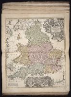
Alternative Title:
General map of Great Britain and Ireland with part of Holland Flandres France &c. agreable to modern history by the heirs of late Mr. Homann at Nueremburg 1749, priviledged by Emperours Majesty
Publisher:
Edentibg. Homan[n]ianis heredibus
Subject (Geographic):
Great Britain --Maps --Early works to 1800 and Ireland --Maps --Early works to 1800