Skip to search
Skip to main content
Skip to first result
Search
You Searched For
Format
cartographic
Language
Latin
New Search
Search Results
Published / Created:
[1680?]
Call Number:
32 1680
Container / Volume:
BRBL_00042
Image Count:
1
Resource Type:
Maps, Atlases & Globes
Subject (Geographic):
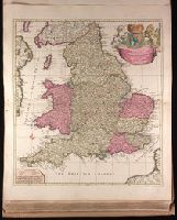
England--Maps--Early works to 1800
Found in:
Beinecke Rare Book and Manuscript Library > Anglia Regnum in omnes suos ducatus. Comitatus, et Provincias divisum Auctore F. de Wit.
Creator:
Published / Created:
ca. 1700?]
Call Number:
1973 Folio 18
Image Count:
1
Resource Type:
Maps, Atlases & Globes
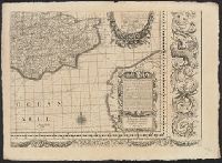
Description:
"Cum privilegio.", Appeared in Peter Schenk's Atlas contractus, ca. 1700., Backed with paper. Ms. no. "48" in lower-right corner. Sheet measures 62.8 x 53.7 cm. No. 45 of 87 maps bound together., Bar scales given in "milliaria Anglica," "milliaria Germanica," and "milliaria Gallica"., Prime meridian: Ferro., Relief shown pictorially., and Watermark.
Publisher:
Peter Schenk,
Subject (Geographic):
England--Maps--Early works to 1800.
Subject (Name):
Schenk, Peter, 1660-1718 or 1719. Atlas contractus.
Found in:
Beinecke Rare Book and Manuscript Library > Anglia in septem Anglo-Saxonum regna omnesque hodiernas regiones ordine distincta [cartographic material] / ededit Petrus Schenk.
Published / Created:
[1720?]
Call Number:
32 600A
Container / Volume:
BRBL_00045
Image Count:
1
Resource Type:
Maps, Atlases & Globes
Subject (Geographic):
England--Maps--Early works to 1800
Found in:
Beinecke Rare Book and Manuscript Library > Angliae Regnum tam in septem antiqua Anglo-Saxonum ... per Nicolm. Visscher ...
Published / Created:
[1692?]
Call Number:
32 1692
Container / Volume:
BRBL_00042
Image Count:
12
Resource Type:
Maps, Atlases & Globes
Subject (Geographic):
England--Maps--Early works to 1800
Found in:
Beinecke Rare Book and Manuscript Library > Angliae totius tabula cum distantius in itinerantium usum accomadata ... Philip Lea. Iohannes Adams ... descripsit. Thomas Burnford ... sculpsit.
Published / Created:
[1579?]
Call Number:
319 1579
Container / Volume:
BRBL_00039
Image Count:
2
Resource Type:
Maps, Atlases & Globes
Description:
Preliminary record.
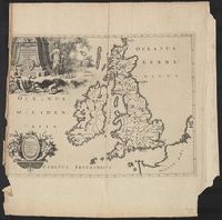
Subject (Geographic):
British Isles--Maps--Early works to 1800
Found in:
Beinecke Rare Book and Manuscript Library > Angliae, Scotiae, et Hiberniae, sive Britannicae: Insularum descriptio.
Published / Created:
[1550?]
Call Number:
316 1550
Container / Volume:
BRBL_00039
Image Count:
1
Resource Type:
Maps, Atlases & Globes
Description:
Preliminary record.
Subject (Geographic):
Holy Roman Empire--Maps--Early works to 1800
Found in:
Beinecke Rare Book and Manuscript Library > Annauniae Rhetiae pars, Seu Vallium Solis, et Annaniae Topographica intra suos Confines descriptio Suae Excellentiae Vigilio Sac: Rom: Imp: Comiti De Thunn Cubiculario Caes: actu: &c.&c. dicata cura, et manu Dris Francisci Manfroni delineata. Franc: Schau
Creator:
Published / Created:
[1714?]
Call Number:
3190 No. 4
Container / Volume:
BRBL_00041
Image Count:
1
Resource Type:
Maps, Atlases & Globes
Description:
Appears in Pieter van der Aa's La Galerie Agréable du Monde [1714?]. and Prime meridian: Ferro.
Publisher:
Apud Peter um Vander Aa,
Subject (Geographic):
British Isles--Early works to 1800--Maps
Found in:
Beinecke Rare Book and Manuscript Library > Antiquorum Britanniae Episcopatuum geographica descriptio.
Creator:
Call Number:
390 1640
Container / Volume:
BRBL_00192
Image Count:
1
Resource Type:
Maps, Atlases & Globes
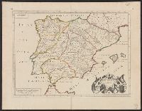
Description:
"Cum priuilegio Regio.", Bar scale given in "scala milliarum.", Hand colored borders., Ms. no. on recto and verso: 155. Stamp on vers, and Relief shown pictorially.
Subject (Geographic):
Spain--Maps--Early works to 1800
Found in:
Beinecke Rare Book and Manuscript Library > Antiquorum Hispaniae episcopatuum geographica descriptio.
Creator:
Published / Created:
1571?]
Call Number:
60 1571
Container / Volume:
BRBL_00321
Image Count:
2
Resource Type:
Maps, Atlases & Globes
Alternative Title:
Aphricae tabvla IIII
Description:
"Probably by Münster" (Norwich)., Pg. no. on verso: 16., Similar to example in Norwich, but lacking pg. nos. on recto., and Text on verso: Quarta Aphricae tabula ...
Publisher:
Heinrich Petri,
Subject (Geographic):
Africa--Maps--Early works to 1800
Subject (Name):
Petri, Heinrich, 1508-1579
Found in:
Beinecke Rare Book and Manuscript Library > Aphricae tabula IIII.
Creator:
Published / Created:
1535?]
Call Number:
60 1535
Container / Volume:
BRBL_00321
Image Count:
2
Resource Type:
Maps, Atlases & Globes
Alternative Title:
Aphricae tabula quarta continet Libyam et duas Aethiopias
Description:
Appears in Fries' 1535 Ptolemy., Includes ill., Relief shown pictorially., Sheet measures 40 x 50 cm., Signature mark: I4., Title from caption on verso., and Watermark: Bunch of grapes.
Publisher:
J. Grüninger?,
Subject (Geographic):
Africa--Maps--Early works to 1800
Found in:
Beinecke Rare Book and Manuscript Library > Aphricae tabula quarta continet Libyam & duas Aethiopias.
Branch:v1.61.8 ,Deployed:2024-06-20T11:15:15-04:00