Skip to search
Skip to main content
Skip to first result
Search
You Searched For
Format
cartographic
Language
Latin
New Search
Search Results
Published / Created:
1597
Call Number:
3331 Z95 1597
Container / Volume:
BRBL_00082
Image Count:
2
Resource Type:
Maps, Atlases & Globes
Description:
Preliminary record.
Subject (Geographic):
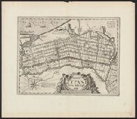
Zijpe (Netherlands : Gemeente)--Maps--Early works to 1800
Found in:
Beinecke Rare Book and Manuscript Library > Agri Zypani nova descript.
Published / Created:
[1640?]
Call Number:
3618 1640
Image Count:
1
Resource Type:
Maps, Atlases & Globes
Description:
Elbe River from source to sea.
Publisher:
Clemendt de Jonghe,
Subject (Geographic):
Elbe River (Czech Republic and Germany)--Maps--Early works to 1800
Found in:
Beinecke Rare Book and Manuscript Library > Albis Fluvius Germaniae Celebris A Fontibus ad Ostie ...
Published / Created:
[1640?]
Call Number:
3627 Sw12 1630A
Container / Volume:
BRBL_00140
Image Count:
2
Resource Type:
Maps, Atlases & Globes
Description:
Verso: Text.
Subject (Geographic):
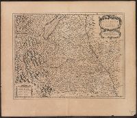
Swabia (Germany)--Maps--Early works to 1800
Found in:
Beinecke Rare Book and Manuscript Library > Alemannia sine Suevia Superior. A Christophoro Hurtero.
Creator:
Published / Created:
ca. 1662?]
Call Number:
53 1662
Container / Volume:
BRBL_00283
Image Count:
2
Resource Type:
Maps, Atlases & Globes
Description:
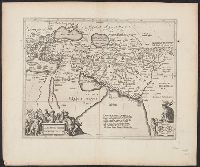
From: Nieuwen atlas ... Amstelodami : Apud Ioannem Ianssonium, [1662?]., Relief shown pictorially., Sheet measures 50 x 60 cm., and Verso: Text in Latin, with signature 3Q.
Publisher:
Jan Jansson,
Subject (Geographic):
Middle East--Maps--Early works to 1800
Subject (Name):
Jansson, Jan, 1588-1664. Atlas novus. Dutch
Found in:
Beinecke Rare Book and Manuscript Library > Alexandri Magni Macedonis expeditio.
Published / Created:
[1660?]
Call Number:
3763 1660
Image Count:
2
Resource Type:
Maps, Atlases & Globes
Description:
Verso: Text.
Publisher:
G. Blaeuw,
Subject (Geographic):
Graubünden (Switzerland)--Maps--Early works to 1800
Found in:
Beinecke Rare Book and Manuscript Library > Alpinae feu Foederatae Rhaetiae Subditarum quo ei Terrarum nova descriptio. Evert Symons Z. Hamors Vesdt Sculp.
Published / Created:
[1630?]
Call Number:
38345 1630A
Container / Volume:
BRBL_00178
Image Count:
1
Resource Type:
Maps, Atlases & Globes
Subject (Geographic):
Bas-Rhin (France)--Maps--Early works to 1800
Found in:
Beinecke Rare Book and Manuscript Library > Alsatia Landgraviatus, Cum Suntgoia et Brisgoia. Ger. Mercatare Auctore.
Creator:
Published / Created:
[1734?]
Call Number:
90 1700A
Container / Volume:
BRBL_00698
Image Count:
1
Resource Type:
Maps, Atlases & Globes
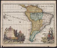
Description:
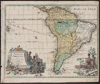
Cross Collection no. 325., Ms. no. in upper right corner: no. 74., Neat line measures 31 x 40.5 cm., and Relief shown pictorially.
Publisher:
Sumtibus C. Weigelii viduae, Norimbergae,
Subject (Geographic):
South America--Maps--Early works to 1800
Found in:
Beinecke Rare Book and Manuscript Library > America Meridionalis / studio Guilielmi de L'Isle ...
Creator:
Published / Created:
[1734?]
Call Number:
90 1734
Container / Volume:
BRBL_00731
Image Count:
1
Resource Type:
Maps, Atlases & Globes
Description:
Relief shown pictorially. and Sheet measures 36.5 x 44 cm. Ms. title on verso with ms no. "101." Franklin Collection no. 131 1734-1.
Publisher:
Sumtibus C. Weigelii viduae, Norimbergae,
Subject (Geographic):
South America--Maps--Early works to 1800
Found in:
Beinecke Rare Book and Manuscript Library > America Meridionalis / studio Guilielmi de L'Isle ...
Creator:
Published / Created:
[176-?]
Call Number:
90 1725A
Container / Volume:
BRBL_00661
Image Count:
1
Resource Type:
Maps, Atlases & Globes
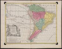
Description:
Imperfect: circles cut around corners, with no loss of text. No watermark. Sheet measures 53.4 x 68.2 cm., Includes five bar scales., Prime meridian: Ferro., Relief shown pictorially., and Watermark.
Publisher:
Venalis prostat Augustae Vindelicorum apud Tobiam Conr. Lotter ...,
Subject (Geographic):
South America--Maps--Early works to 1800
Subject (Name):
Lotter, Gustav Conrad, 1746-1776, engraver and Lotter, Tobias Conrad, 1717-1777
Found in:
Beinecke Rare Book and Manuscript Library > America Meridionalis : concin[n]ata juxta observationes Dnñ Acad. Regalis Scientiarum et nonnullorum aliorum, et juxta annotationes recentissimas / per G. de L'Isle, geographum ; Gustav Conrad Lotter, sculps., Aug. Vind.
Creator:
Published / Created:
1730?]
Call Number:
71 1730A
Container / Volume:
BRBL_00362
Image Count:
1
Resource Type:
Maps, Atlases & Globes
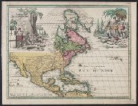
Description:
Includes ill. of natives in upper left and right., Relief shown pictorially., Some French notes., and Yale's copy annotated in ink in upper right margin: Nr073.
Publisher:
[C. Weigelii Viduce?,
Subject (Geographic):
North America--Maps--Early works to 1800
Found in:
Beinecke Rare Book and Manuscript Library > America Septentrionalis / studio Guilielmi de l'Isle, geographi Regii Parisiensis ; sumtibus C. Weigelii Viduce, Norimbergae.
Branch:v1.61.8 ,Deployed:2024-06-20T11:14:46-04:00