Appeared in Jode's Speculum orbis terrarum, Blank on verso., Engraving attributed to Antonie Wierix., Manuscript number on verso "No. 114.", Margins include descriptive text and four allegorical-historical vignettes (each 7 cm in diameter)., Relief shown pictorially., and Watermark.
Covers the eastern hemisphere above 25⁰ S., Imperfect: chipped along edges, with no loss of text. Cross collection no. 13., Includes ill., Relief shown pictorially., and Text and diagram titled "Die Nammen und Gegne der Wind" on verso, with signature mark: ij.
Claudii Ptolemaei Geographicae enarrationis libri octo.
Image Count:
2
Resource Type:
Maps, Atlases & Globes
Alternative Title:
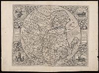
Tabula superioris Indiae & Tartariae maioris, Tabula superioris Indiae et Tartariae maioris, and Tabvla svperioris Indiae et Tartariae maioris.
Description:
Appears in the author's Geographia (Lyon, 1535 edition)., Caption title from verso., Descriptive text within ornamental borders on verso; paginated 43., In margin: climatic and latitudinal notes., Includes names of places and natural features., Map of the Far East and eastern Siberia., Relief shown pictorially., Text in Latin., and Watermark.
Publisher:
[Melchior and Gaspard Trechsel],
Subject (Geographic):
East Asia--Maps--Early works to 1800. and Siberia, Eastern (Russia)--Maps--Early works to 1800.
Subject (Name):
Ptolemy, 2nd cent., Trechsel, Gaspard, active 1529-1549, and Trechsel, Melchior, active 1529-1549
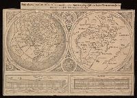
Universaltafel des situs Asiae, Africae und Europae, samt der gelegenhäit des lands Eden, wie auch eine delineatio der arch Noe bäides im grund und auftitz
Description:
Caption title., Includes two images of Noah's ark., One partial hemisphere map of Europe, Africa, and Asia and one map of the Biblical Middle East., and Relief shown pictorially.
Publisher:
[publisher not identified],
Subject (Geographic):
Middle East--Maps--Early works to 1800. and Northern Hemisphere--Maps--Early works to 1800.
Subject (Topic):
Bible.--Old Testament--Geography--Maps--Early works to 1800.