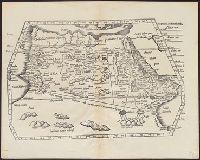
Aphricae tabula quarta continet Libyam et duas Aethiopias
Description:
Appears in Fries' 1535 Ptolemy., Includes ill., Relief shown pictorially., Sheet measures 40 x 50 cm., Signature mark: I4., Title from caption on verso., and Watermark: Bunch of grapes.
Maps of the Orinoco-Essequibo region, South America. Compiled for the Commission appointed by the
Image Count:
1
Resource Type:
Maps, Atlases & Globes
Subject (Geographic):
Amazon River--Discovery and exploration--Spanish, Amazon River--Maps, Caribbean Area--Maps--Early works to 1800, Colombia --Maps, Guyana --Maps, Orinoco River Valley (Venezuela and Colombia) --Maps, and Venezuela --Maps
Appears in Fries' 1535 Ptolemy., Covers Morocco and northern Algeria., Includes ill., Relief shown pictorially., Signature mark: II., Text on verso., Title from verso., and Watermark: bunch of grapes.
Publisher:
J. Grüninger?,
Subject (Geographic):
Algeria--Maps--Early works to 1800 and Morocco--Maps--Early works to 1800
Claudii Ptolemaei Geographicae enarrationis libri octo.
Image Count:
2
Resource Type:
Maps, Atlases & Globes
Alternative Title:
Tabula superioris Indiae & Tartariae maioris, Tabula superioris Indiae et Tartariae maioris, and Tabvla svperioris Indiae et Tartariae maioris.
Description:
Appears in the author's Geographia (Lyon, 1535 edition)., Caption title from verso., Descriptive text within ornamental borders on verso; paginated 43., In margin: climatic and latitudinal notes., Includes names of places and natural features., Map of the Far East and eastern Siberia., Relief shown pictorially., Text in Latin., and Watermark.
Publisher:
[Melchior and Gaspard Trechsel],
Subject (Geographic):
East Asia--Maps--Early works to 1800. and Siberia, Eastern (Russia)--Maps--Early works to 1800.
Subject (Name):
Ptolemy, 2nd cent., Trechsel, Gaspard, active 1529-1549, and Trechsel, Melchior, active 1529-1549
Decorated with sea monsters, mermaids, exotic animals, and cannibals, this wood cut map provides a marked contrast to the simplistic diagrams considered the earliest printed world maps. While the latter presented a world view based in Judeo-Christian theo
Alternative Title:
Typus cosmographicus universalis and Typvs cosmographicvs vniversalis
Description:
Appears in Johann Huttich's Novus orbis regionum. Basel. 1532. and Relief shown pictorially.
Publisher:
[publisher not identified],
Subject (Name):
Holbein, Hans, 1497-1543 and Huttich, Johann, 1480?-1544. Novus orbis regionum.
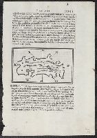
Appears in Bordon's Libro di Benedetto Bordone nel qual si ragiona de tutte l'isole del mondo. 1528., Ciampagu oriented with north to the right. Iava Maggiore, Sondur, and Condur oriented with north toward the lower right., and Covers Japan, depicted as one isl
Publisher:
Nicolo d'Aristotile, detto Zoppino,
Subject (Geographic):
Japan--Maps--Early works to 1800 and Java (Indonesia)--Maps--Early works to 1800
Subject (Name):
Bordon, Benedetto, 1450-1530. Libro di Benedetto Bordone nel qual si ragiona de tutte l'isole del mondo and Zoppino, Nicolò, fl. 1508-1544