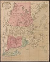
Includes compilation data and insets of "Fort Frederik," ca. 1:1,680 and "A plan of Boston Harbor from an accurate survey," ca. 1:150,000., Prime meridian: London and Ferro., and Relief shown pictorially.
Publisher:
Published according to Act by Thos. Jefferys Geographer to His Royal Highness the Prince of Wales near Charing Cross,
The American atlas; or, A geographical description of the whole continent of America; wherein are
Image Count:
1
Resource Type:
Maps, Atlases & Globes
Description:
Stamped on verso: 16.
Subject (Geographic):
America --Maps --Early works to 1800, Connecticut --Maps --Early works to 1800, Massachusetts --Maps --Early works to 1800, New England --Maps --Early works to 1800, and Rhode Island --Maps --Early works to 1800
BEIN 2003 Folio 85: No. 18 of 45 maps bound together with binder's spine title: Atlas of America; ms. table of contents. Bookplate: Robinson. Bookplate of Paul Mellon., Hand colored., Includes compilation data and inset of A plan of Boston Harbor from an accurate survey, ca. 1:150,000., Prime meridian: London and Ferro., Relief shown pictorially., and Scale [ca. 1:440,000].
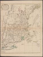
A textual note at upper left reads "The Course of the Ohio or Alliganey River and its Branches are laid down from Surveys and Draughts made on the Spot by M.r Gist and others in the Years 1751, 2, 3 & 4". and Cartouche designed by Francis Hayman and engraved
Publisher:
Thomas Jefferys,
Subject (Geographic):
Maryland--Maps--Early works to 1800., Middle Atlantic States--Maps--Early works to 1800., and Virginia--Maps--Early works to 1800.
Subject (Name):
Byrd, William, 1674-1744., Churton, William, 1710-1767, surveyor., Dalrymple, John, -1766, surveyor., Dandridge, William, -1743., Fitzwilliam, Richard, -1744., and Fry, Joshua, approximately 1700-1754, ca
"Printed for Robt. Sayer at No. 53 in Fleet Street, London.", "Published 12th May 1794, by Laurie & Whittle, No. 53, Fleet Street, London.", "To the Right Honourable, George Dunk Earl of Halifax ...", Hand colored., Includes distance chart., and Prime meridians: L
Publisher:
Laurie & Whittle,
Subject (Geographic):
Maryland--Maps, Middle Atlantic States--Maps--Early works to 1800, and Virginia--Maps--Early works to 1800
Subject (Name):
Jefferson, Peter, 1708-1757, Jefferys, Thomas, d. 1771, Robert Laurie and James Whittle, and Sayer, Robert, 1725-1794
Fry, Joshua, 1700 (ca.)-1754, creator Halifax, George Montagu-Dunk, Earl of, 1716-1771 Jefferson, Peter, 1708-1757 Jefferys, Thomas, d. 1771
Published / Created:
[1755]
Call Number:
2003 Folio 85
Image Count:
1
Description:
BEIN 2003 Folio 85: No. 21 of 45 maps bound together with binder's spine title: Atlas of America; ms. table of contents. Bookplate: Robinson. Bookplate of Paul Mellon., drawn by Joshua Fry & Peter Jefferson in 1751., Hand colored., Includes distance chart added by J. Dalrymple, London Jany. ye. 1st. 1755., Prime meridian: Philadelphia and Curratuck Inlet., Relief shown pictorially., Scale [ca. 1:650,000]., and To the Right Honourable, George Dunk Earl of Halifax ...
Publisher:
Thos. Jeffreys
Subject (Geographic):
Maryland -- Maps -- Early works to 1800, Middle Atlantic States -- Maps -- Early works to 1800, and Virginia -- Maps -- Early works to 1800