Department of State publication ; 803. and Department of State, map series ; no. 5 (Publication no. 803)
Description:
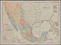
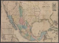
"Reproduced in 1935 to accompany ʻTreaties and other international acts of the United States of America,ʾ Volume 5. See Document 129.", "The earliest of five or more 1847 editions. The copy added to the Treaty of Guadalupe Hidalgo of February 2, 1848, in the archives of the Department of State.", Includes table of distances, table of statistics, "Profile of the route between Mexico and Vera Cruz," and "Profile of the route b[e]tween Mexico and Acapulco.", Insets: Carta de los caminos &c. desde Vera Cruz y Alvarado a Méjico -- Map showing the battle grounds of the 8th and 9th May 1846 -- Chart of the bay of Vera Cruz., Prime meridian: Washington., and Relief shown by hachures and spot heights.
Carta de los caminos &c. desde Vera Cruz y Alvarado a Méjico.
Description:
Includes distance table, list of states, "Profile of the route between Mexico and Vera Cruz," and "Profile of the route btween [sic] Mexico and Acapulco.", Insets: Carta de los caminos &c. desde Vera Cruz y Alvarado a Méjico -- Map showing the battle grounds of the 8th and the 9th, May 1846 -- Chart of the Bay of Vera Cruz., Prime meridian: Washington., and Relief shown by hachures and spot heights.
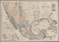
"The Disturnell Map of 1847 reproduced for the Friends of the Bancroft Library, February 2, 1948.", Includes distance table, "tabla estadistica," and 2 profiles., Insets: Carta de los caminos &c. desde Vera Cruz y Alvarado a Méjico -- Map showing the battle grounds of the 8th and 9th May 1846 -- Chart of the bay of Vera Cruz., Issued to accompany: The Treaty of Guadalupe Hidalgo ... / edited by George P. Hammond. 1949., Prime meridian: Washington., and Relief shown by hachures and spot heights.
Publisher:
The Friends of the Bancroft Library,
Subject (Geographic):
Mexico--Boundaries--United States--Maps, Mexico--Maps, Southwest, New--Maps, and United States--Boundaries--Mexico--Maps
Subject (Name):
A. Hoen & Co, Bancroft Library. Friends, and Mexico. Treaties, etc. United States, 1848 Feb. 2
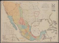
Carta de los caminos &c. desde Vera Cruz y Alvarado a Méjico. and Map of the Republic of Mexico
Description:
Includes distance table, list of states, "Profile of the route between Mexico and Vera Cruz," and "Profile of the route btween [sic] Mexico and Acapulco.", Inscription on inside of covers, "W.C. Wescott, U.S. Army.", Insets: Carta de los caminos &c. desde Vera Cruz y Alvarado a Méjico -- Map showing the battle grounds of the 8th and the 9th, May 1846 -- Plan of Monterey and its environs -- Chart of the Bay of Vera Cruz -- Tampico and its environs., Prime meridian: Washington., Relief shown by hachures and spot heights., and Statistical data inside cover.
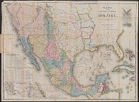
Carta de los caminos &c. desde Vera Cruz y Alvarado a Méjico.
Description:
Differs from other 1846 variants in having all the following details: "scale of English miles" instead of "scale of miles," "revised edition," "Rinconada Pass" near Monterrey, Mexico, and trail between San Antonio and Austin (source: Rittenhouse's Disturnell's treaty map. Stagecoach Press, 1965.), Includes distance and statistics tables, and inset of "Carta de los caminos &c. desde Vera Cruz y Alvarado a Méjico.", Library's copy 1 stamped in red ink: sold by E.P. Nash, Petersburg, VA., Prime meridian: Washington., and Relief shown by hachures and spot heights.