Skip to search
Skip to main content
Skip to first result
Search
You Searched For
Genre
Maps
Resource Type
Maps, Atlases & Globes
Creator
L'Isle, Guillaume de, 1675-1726
New Search
Search Results
Creator:
Published / Created:
1701
Call Number:
39 1701A
Image Count:
1
Resource Type:
Maps, Atlases & Globes
Publisher:
Chez l'auteur ...,
Subject (Geographic):
Spain--Maps--Early works to 1800
Subject (Name):
Méndez Silva, Rodrigo, 1607-1675
Found in:
Beinecke Rare Book and Manuscript Library > L'Espagne, dressée sur la description qui en a été faite par Rodrigo Mendez Sylva ... / par G. de l'Isle ...
Creator:
Published / Created:
[1740?]
Call Number:
18 1740A
Container / Volume:
BRBL_00682
Image Count:
1
Resource Type:
Maps, Atlases & Globes
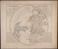
Description:
"Rectifier selon la carte de Monsieur Jean Kyrilow, premier secretaire de conseil de l'Empire de Russie publier en l'anne ́1734 ... ", Cross collection no. 54., Includes text of letter written by "Monsieur Sw, Prime meridian: Ferro., and Relief shown pictorially.
Publisher:
Chez Jean Cóvens et Corneille Mortier,
Subject (Geographic):
Northern Hemisphere--Maps--Early works to 1800
Subject (Name):
Cóvens et Mortier
Found in:
Beinecke Rare Book and Manuscript Library > L'hemisphere septentrional pour voir plus distinctement les Terres Arctiques / par Guillaume de l'isle de l'Academie Rle. des Sciences.
Creator:
Published / Created:
[175-?]
Call Number:
43 1740
Container / Volume:
BRBL_00250
Image Count:
1
Resource Type:
Maps, Atlases & Globes
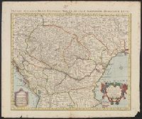
Alternative Title:
Nova et accurata Regni Hungariae tabula
Description:
"Avec privilege"., Appeared in Cóvens et Mortier's Nieuwe atlas., Imperfect: torn along bottom fold, with no loss of text. Ms. no. above neat line: 25. Sheet measures 55.3 x 65.7 cm., Includes four bar scales., Prime meridian: Ferro, and Relief shown pictorially.
Publisher:
Chez I. Còvens et C. Mortier,
Subject (Geographic):
Balkan Peninsula--Maps--Early works to 1800 and Hungary--Maps--Early works to 1800
Subject (Name):
Cóvens et Mortier
Found in:
Beinecke Rare Book and Manuscript Library > Le Royaume de Hongrie et des pays qui en dependoient autrefois / dressée sur un grand nombre de memoires et cartes manuscrites ou ímprimées ; rectifiez par les observations du Cte. Marsilii et quelques autres par Guillaume de l'Isle ....
Creator:
Published / Created:
1729]
Call Number:
44 1729
Container / Volume:
BRBL_00254
Image Count:
1
Resource Type:
Maps, Atlases & Globes
Description:
"Ad novam editionem operum Constantini Porphyrogeniti quae prodit studio Anselmi Bandurii, Ragusini monachi Benedictini Melitensis cum ejusdem notis et animadversionibus.", Appears in Anselmo Banduri's Imperium orientale. 1729., and Relief shown pictorially.
Publisher:
Ex typographia Bartholomaei Javarina,
Subject (Geographic):
Balkan Peninsula--History--Maps--Early works to 1800 and Turkey--History--Maps--Early works to 1800
Subject (Name):
Banduri, Anselmo Maria, 1675-1743. Imperium orientale. 1729
Found in:
Beinecke Rare Book and Manuscript Library > Orbis Romani descriptio seu divisio per themata sub Imperatoribus Constantinopolitanis post Heraclii tempora facta / auctore Guillelmo Del'Isle è Regiâ Scientiarum Academiâ.
Creator:
Published / Created:
1712
Call Number:
400 1712
Container / Volume:
BRBL_00232
Image Count:
1
Resource Type:
Maps, Atlases & Globes
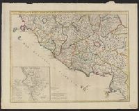
Description:
"Cum priveilegio.", Inset: Urbs septicollis., and Relief shown pictorially.
Publisher:
Sold by John Senex at the Globe against St. Dunstan's Church in Fleetstreet ...,
Subject (Geographic):
Italy, Central--Historical geography--Maps--Early works to 1800 and Rome (Italy)--Historical geography--Maps--Early works to 1800
Found in:
Beinecke Rare Book and Manuscript Library > Regionum Italiae mediarum tabula geographica : pernoscendis historiae Romanae primordiis praesertium utilis, sed et cui multa sequioris aevi addita / auctore G. DelIisle, e Regiâ Scientiarum Academiae socio.
Creator:
Published / Created:
Apr. 1711.
Call Number:
400 1711
Container / Volume:
BRBL_00232
Image Count:
1
Resource Type:
Maps, Atlases & Globes
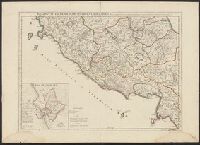
Description:
"Cum priveilegio.", Has watermarks., Inset: Urbs septicollis., and Relief shown pictorially.
Publisher:
Apud Auctorem ... [sur] le Quai de l'Horloge,
Subject (Geographic):
Italy, Central--Historical geography--Maps--Early works to 1800 and Rome (Italy)--Historical geography--Maps--Early works to 1800
Subject (Name):
Desrosiers
Found in:
Beinecke Rare Book and Manuscript Library > Regionum Italiae mediarum tabula geographica : pernoscendis historiae Romanae primordiis praesertium utilis, sed et cui multa sequioris aevi addita / autore G. DelIisle, Regiae Scientiarum Academiae socio ; Dereosier sculp.
Creator:
Published / Created:
Dec. 1714.
Call Number:
408 1714
Container / Volume:
BRBL_00238
Image Count:
1
Resource Type:
Maps, Atlases & Globes
Alternative Title:
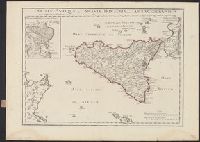
Veterum Syracusarum typus.
Description:
Inset: Veterum Syracusarum typus., Relief shown pictorially., Shows Malta and parts of Italy and Tunisia., and Watermarks include Maltese cross in rosary.
Publisher:
Apud auctorem in Ripa Sequanae, vulgo dicta le Quay de lHorologe,
Subject (Geographic):
Sicily (Italy)--Historical geography--Maps--Early works to 1800 and Syracuse (Italy)--Historical geography--Maps--Early works to 1800
Found in:
Beinecke Rare Book and Manuscript Library > Siciliae antiquae quae et Sicania et Trinacria dicta, tabula geographica / auctore Guillelmo DelIsle è Regia scientarum Academiâ.
Creator:
Published / Created:
[between 1715 and 1720?]
Call Number:
400 1715A
Container / Volume:
BRBL_00232
Image Count:
1
Resource Type:
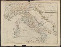
Maps, Atlases & Globes
Description:
Relief shown pictorially.
Publisher:
Sold by I. Senex at the globe over against St. Dunstan's Church in Fleetstreet ... ,
Subject (Geographic):
Italy--Historical geography--Maps--Early works to 1800, Italy--History--To 476--Maps--Early works to 1800, and Rome--Maps--Early works to 1800
Subject (Name):
Senex, John, d. 1740
Found in:
Beinecke Rare Book and Manuscript Library > Tabula Italiae antiquae in regiones XI ad Augusto divisiae et tum ad mensuras itineraris tum ad observationes astronomicas exactae / accurante Guillelmo Del'isle ... ; Joan. Bap. Liébaux sculpsit.
Creator:
Published / Created:
[between 1715 and 1720?]
Call Number:
400 1715A
Container / Volume:
BRBL_00232
Image Count:
1
Resource Type:
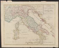
Maps, Atlases & Globes
Description:
Relief shown pictorially.
Publisher:
Sold by I. Senex at the globe over against St. Dunstan's Church in Fleetstreet ... ,
Subject (Geographic):
Italy--Historical geography--Maps--Early works to 1800, Italy--History--To 476--Maps--Early works to 1800, and Rome--Maps--Early works to 1800
Subject (Name):
Senex, John, d. 1740
Found in:
Beinecke Rare Book and Manuscript Library > Tabula Italiae antiquae in regiones XI ad Augusto divisiae et tum ad mensuras itineraris tum ad observationes astronomicas exactae / accurante Guillelmo Del'isle ... ; Joan. Bap. Liébaux sculpsit.
Creator:
Published / Created:
[between 1715 and 1720?]
Call Number:
400 1715A
Container / Volume:
BRBL_00232
Image Count:
1
Resource Type:
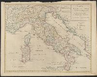
Maps, Atlases & Globes
Description:
Relief shown pictorially.
Publisher:
Sold by I. Senex at the globe over against St. Dunstan's Church in Fleetstreet ... ,
Subject (Geographic):
Italy--Historical geography--Maps--Early works to 1800, Italy--History--To 476--Maps--Early works to 1800, and Rome--Maps--Early works to 1800
Subject (Name):
Senex, John, d. 1740
Found in:
Beinecke Rare Book and Manuscript Library > Tabula Italiae antiquae in regiones XI ad Augusto divisiae et tum ad mensuras itineraris tum ad observationes astronomicas exactae / accurante Guillelmo Del'isle ... ; Joan. Bap. Liébaux sculpsit.
Branch:v1.61.6 ,Deployed:2024-06-12T09:55:36-04:00