"Longitude du meridien de l'Isle de Fer.", Appears in Bellin's Atlas maritime., and Ms. notes on verso. Hand col. Sheet measures 57.3 x 79.8 cm. Cross Collection no. 168.
Publisher:
Dépot de la Marine],
Subject (Geographic):
Canada--Maps--Early works to 1800
Subject (Name):
Bellin, Jacques Nicolas, 1703-1772. Atlas maritime
"Longitude du meridien de l'Isle de Fer.", Appears in Bellin's Atlas maritime., and Stamp: Thorne Collection of Cartogaphy and Geography. Stamp: Karpinski-von Wieser Map Collection. "159"--Manuscript note.
Publisher:
Dépot de la Marine],
Subject (Geographic):
Canada--Maps--Early works to 1800
Subject (Name):
Bellin, Jacques Nicolas, 1703-1772. Atlas maritime and Thorne Collection of Cartogaphy and Geography Stamp
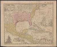
Appears in Homann's Atlas geographicus major ... Normibergae : Curantibus Homannianis heredibus, 1759., Includes notes, ill. of ships in battle, and of Europeans and Native Americans, and four bar scales., Ms. annotations. Ms. no. on verso: 207 III 59. Sheet measures 53.6 x 64.9 cm. Franklin Collection no. 131 1737-2., Relief shown pictorially., Some references suggest earlier possible imprint date., and This edition is at least the second state, as Ludoviciana has replaced Florida as the name of the Louisiana territory.
Publisher:
[Homann Erben?,
Subject (Geographic):
New Spain--Maps--Early works to 1800 and North America--Maps--Early works to 1800
Subject (Name):
Homann Erben (Firm) and Homann, Johann Baptist, 1663-1724. Atlas geographicus major
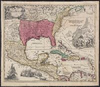
Appears in Homann's Atlas geographicus major ... Normibergae : Curantibus Homannianis heredibus, 1759., Copy 1: Ms. no. on verso: 107. Stamp on verso: Yale, Horace Brown, 1900S. Neat line measures 47.6 x 57.5 on sheet 52 x 62 cm., and Includes notes, ill. of sh
Publisher:
[Homann Erben?,
Subject (Geographic):
New Spain--Maps--Early works to 1800 and North America--Maps--Early works to 1800
Subject (Name):
Homann Erben (Firm) and Homann, Johann Baptist, 1663-1724. Atlas geographicus major
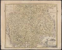
Bar scales given in "milliaria duo Germanica" and "milliaria Italica.", Hand colored. Stamp: Karpinski-von Wieser Map Collection. Manuscript notes in unidentified hand., Prime meridian: Ferro., and Relief shown pictorially.
Publisher:
Edentibus Homannianis Hered., C.P.S.C.M.,
Subject (Geographic):
Trentino-Alto Adige (Italy)--Maps--Early works to 1800 and Tyrol (Austria)--Maps--Early works to 1800
Imperfect: Mutilated with slight loss of information. Hand colored. Stamp: Karpinski-von Wieser Map Collection. "58"--Manuscript note in unidentified hand. and Relief shown pictorially.
Subject (Geographic):
Trentino-Alto Adige (Italy)--Maps--Early works to 1800
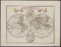
"C. Sepp del. et sculps. 1744.", Cross collection no. 37., In Dutch., Includes 2 smaller circular polar maps, and decorative cartouche., Mounted on linen., Ms. note at head of map: No. J., Relief shown pictorially., and Scale measured at center of hemisphere.