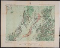
Geographical Surveys West of the 100th Meridian (U.S.)
Published / Created:
1879
Call Number:
841 1879A
Container / Volume:
BRBL_00596
Image Count:
1
Resource Type:
Maps, Atlases & Globes
Alternative Title:
Land classification map of part of southern New Mexico, atlas sheet no. 84 (B)
Description:
"7"--Verso., "Expeditions of 1877.", "Issued June 30, 1879.", "Weyss, Lang and Herman, del."--Lower right border., Includes atla, Relief shown by hachures and spot heights., and Shows land types: agricultural (with irrigation), timber, grazing, and arid and barren.
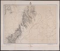
Geographical Surveys West of the 100th Meridian (U.S.)
Published / Created:
[1878]
Call Number:
841 1878B
Container / Volume:
BRBL_00596
Image Count:
1
Resource Type:
Maps, Atlases & Globes
Alternative Title:
Part of southern New Mexico, atlas sheet no. 84 (B)
Description:
"10"--Verso., "Weyss, Lang and Herman, del."-, Differs from 1879 map of identical title in that eastern relief missing on this map and type/text size smaller around margins., and Relief shown by hachures and spot heights. Relief not shown on eastern half of map.
"Ed. Nov. 10, 1863"--Lower right corner., Mounted on linen. Manuscript markings show positions of 2,3,5,6 Corps surrounding Court House., Relief shown by hachures., and Title supplied by cataloger.