Skip to search
Skip to main content
Skip to first result
Search
You Searched For
Date
Unknown
Genre
Maps
Resource Type
Maps, Atlases & Globes
Date Created
[Missing]
New Search
Search Results
Creator:
Call Number:
304 1712
Container / Volume:
BRBL_00033
Image Count:
1
Resource Type:
Maps, Atlases & Globes
Alternative Title:
General Diet of the Empire, or its Parliament.
Description:
Inset illustration of the Reichstag of Holy Roman Empire, with title: The General Diet of the Empire, or it's Parliament.
Subject (Geographic):
Europe, Central--Maps--Early works to 1800, Germany--Maps--Early works to 1800, Hungary--Maps--Early works to 1800, Romania--Maps--Early works to 1800, and Switzerland--Maps--Early works to 1800
Subject (Name):
Holy Roman Empire.--Reichstag and Hughes, Thomas Lowe,--1925---Ownership
Found in:
Beinecke Rare Book and Manuscript Library > A new map of Germany, Hungary, Transilvania & the Suisse cantons : with many remarks not extant in any map : according to ye newest and most exact observations / by Herman Moll, geographer.
Call Number:
1976 Folio 94
Collection Title:
A new universal atlas containing maps of the various empires, kingdoms, states and republics of the
Image Count:
1
Resource Type:
Maps, Atlases & Globes
Subject (Geographic):
Maine
Collection Created:
Philadelphia, S.A. Mitchell, 1849
Found in:
Beinecke Rare Book and Manuscript Library > A new map of Maine
Creator:
Call Number:
401 1811
Container / Volume:
BRBL_00233
Image Count:
1
Resource Type:
Maps, Atlases & Globes
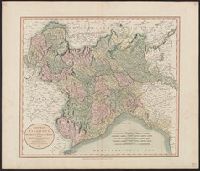
Description:
Hand colored. Stamp: Karpinski-von Wieser Map Collection. Label: 17., Meridian: Greenwich., and Relief shown by hachures.
Subject (Geographic):
Genoa (Italy : Province)--Maps, Milan (Italy : Province)--Maps, Piedmont (Italy)--Maps, and Savoy (France and Italy)--Maps
Found in:
Beinecke Rare Book and Manuscript Library > A new map of Piedmont, the duchies of Savoy and Milan, and the republic of Genoa, with their subdivisions : from the latest authorities / by John Cary.
Creator:
Call Number:
39 1801
Container / Volume:
BRBL_00186
Image Count:
1
Resource Type:
Maps, Atlases & Globes
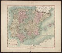
Description:
Appeared in Cary's new universal atlas, London, 1808. and Relief shown pictorially.
Subject (Geographic):
Portugal--Maps and Spain--Maps
Subject (Name):
Cary, John, ca. 1754-1835. Cary's new universal atlas and Hughes, Thomas Lowe,--1925---Ownership
Found in:
Beinecke Rare Book and Manuscript Library > A new map of Spain and Portugal : divided into their respective kingdoms and provinces from the latest authorities / by John Cary, engraver.
Creator:
Call Number:
3614 1799
Container / Volume:
BRBL_00135
Image Count:
1
Resource Type:
Maps, Atlases & Globes
Description:
Appeared in Cary's New universal atlas, London, 1808., Covers East Prussia., and Printed on verso: 36.
Subject (Geographic):
Prussia, East (Poland and Russia)--Maps--Early works to 1800
Subject (Name):
Cary, John, approximately 1754-1835. Cary's new universal atlas and Hughes, Thomas Lowe,--1925---Ownership
Found in:
Beinecke Rare Book and Manuscript Library > A new map of the Kingdom of Prussia : with its divisions into provinces and governments ; from the latest authorities / by John Cary, engraver, 1799.
Creator:
Published / Created:
Undated
Call Number:
1973 Folio 71
Collection Title:
[Atlas nouveau contenant toutes les parties du monde ou sont exactement marques les empires
Image Count:
1
Resource Type:
Maps, Atlases & Globes
Abstract:
Factitious collection of about 549 maps taken from the atlases of the 17th and the beginning of the 18th century, put together with the title "Atlas" and bound in 6 volumes. These volumes originally bore the imprint: Amstelaedamii apvd Reiniervm & Josvam Ottens. Over these words on the title pages of volumes 1-2 and 4-6 is the name of Henrik de Leth who painted them.
Description:
Verso blank.
Subject (Geographic):
British Isles --Maps --Early works to 1800
Subject (Name):
Leth, Hendrik de, 1703-1766, Reiner et Josua Ottens (Firm), Schenck, Peter, 1661-1715, Schenck, Peter, ca. 1698-1752, Valck, G. (Gerard), 1651 or 2-1726, and Wit, Frederik de
Subject (Topic):
Atlases --Early works to 1800
Collection Created:
[A Amsterdam, chez J. Covens & C. Mortier, ca. 1730-ca. 1800]
Found in:
Beinecke Rare Book and Manuscript Library > A new mapp of the kingdome of England, representing the princedome of Wales, and other provinces, cities, market towns, with the roads from town to town and the number of reputed miles between them, are given by inspection without scale or compass
Creator:
Call Number:
32 L84 1766
Container / Volume:
BRBL_00048
Image Count:
1
Resource Type:
Maps, Atlases & Globes
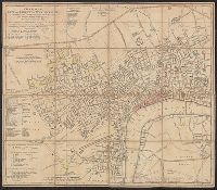
Subject (Geographic):
London (England)--Maps--Early works to 1800 and Westminster (London, England)--Maps--Early works to 1800
Found in:
Beinecke Rare Book and Manuscript Library > A new plan of the city and liberty of Westminster ... / drawn & engraved by Thomas Jefferys ...
Call Number:
1977 Folio 78
Collection Title:
A New and accurate chart of the West-India Islands and coast, with the gulf passage through the New
Image Count:
1
Resource Type:
Maps, Atlases & Globes
Alternative Title:
Petit Guave in the island of Hispaniola, pl. 32
Subject (Geographic):
Hispaniola
Subject (Topic):
Nautical charts
Collection Created:
London, Printed for Robert Sayer and John Bennett, Fleet-Street, 1779
Found in:
Beinecke Rare Book and Manuscript Library > A plan of Fort St. Louis harbour on the south side of Hispaniola, pl. 31.
Call Number:
1977 Folio 78
Collection Title:
A New and accurate chart of the West-India Islands and coast, with the gulf passage through the New
Image Count:
1
Resource Type:
Maps, Atlases & Globes
Alternative Title:
Plan of the bay and town of Bayaha or Port Dauphin in the island of Hispaniola, pl. 37.
Collection Created:
London, Printed for Robert Sayer and John Bennett, Fleet-Street, 1779
Found in:
Beinecke Rare Book and Manuscript Library > A plan of Monte-Christe Bay with the Seven Brothers on the north coast of St. Domingo, pl. 38
Call Number:
1977 Folio 78
Collection Title:
A New and accurate chart of the West-India Islands and coast, with the gulf passage through the New
Image Count:
1
Resource Type:
Maps, Atlases & Globes
Alternative Title:
A plan on the town and harbour of Cap Francois in the island of St. Domingo. pl. 36
Collection Created:
London, Printed for Robert Sayer and John Bennett, Fleet-Street, 1779
Found in:
Beinecke Rare Book and Manuscript Library > A plan of the road of Port Paix in the island of Hispaniola, pl. 35.
Branch:v1.64.0 ,Deployed:2024-09-11T10:25:40-04:00