Skip to search
Skip to main content
Skip to first result
Search
You Searched For
Genre
Maps
Language
English
New Search
Search Results
Creator:
Published / Created:
1943
Call Number:
556gme 1943
Container / Volume:
BRBL_00294
Image Count:
1
Resource Type:
Maps, Atlases & Globes
Description:
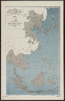
"12 March 1943.", "Map no. 1400.", "Project no. EP 162.", and Also covers Southeast Asia.
Publisher:
Office of Strategic Services],
Subject (Geographic):
East Asia--Maps
Subject (Name):
United States. Office of Strategic Services. Research and Analysis Branch
Subject (Topic):
Railroads--East Asia--Maps, Railroads--Southeast Asia--Maps, and World War, 1939-1945--Japan--Territorial expansion--Maps
Found in:
Beinecke Rare Book and Manuscript Library > Far East, Japanese occupied area, major railroads [cartographic material] / Board of Economic Warfare, Enemy Branch ; drawn in R. and A., OSS.
Creator:
Published / Created:
1984
Call Number:
80 1984
Container / Volume:
BRBL_00536
Image Count:
2
Resource Type:
Maps, Atlases & Globes
Description:
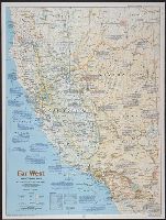
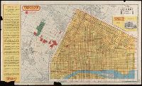
Ancillary maps on verso : 1. Spanish imprint, 1697-1823 -- 2. Sudden transition, 1821-1860 -- 3. The new Eden, 1860-1900 -- 4. Water, the key to growth, 1900-1940 -- 5. Explosive growth, 1940-present. Inset: and Folded title: The making of America, Far West.
Publisher:
National Geographic Society,
Subject (Geographic):
California--Maps and Nevada--Maps
Found in:
Beinecke Rare Book and Manuscript Library > Far West / produced by the Cartographic Division, National Geographic Society.
Published / Created:
1915
Call Number:
774 Y82 1915
Container / Volume:
BRBL_00500
Image Count:
1
Resource Type:
Maps, Atlases & Globes
Description:
Also shows railroads, inter-urban electric lines, main roads., Roads in each townships are numbered., and Zincograph colored to show townships.
Publisher:
Wilmer Atkinson Company ,
Subject (Geographic):
York County (Pennsylvania)--Maps
Found in:
Beinecke Rare Book and Manuscript Library > Farm journal map of York County, Pennsylvania.
Creator:
Published / Created:
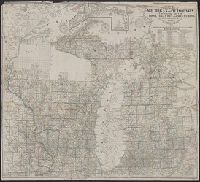
1857
Call Number:
754 1857
Container / Volume:
BRBL_00416
Image Count:
1
Resource Type:
Maps, Atlases & Globes
Alternative Title:
Township map of Michigan and Wisconsin.
Description:
1771, Includes index of mines., Inset: Plat of the balance of the coast of Lake Superior., and Relief shown by hachures. Depths shown by soundings.
Publisher:
John Farmer,
Subject (Geographic):
Michigan--Maps, Superior (Lake, Region)--Maps, and Wisconsin--Maps
Found in:
Beinecke Rare Book and Manuscript Library > Farmer's township map of Michigan and Wisconsin : embracing part of Iowa Illinois and Minnesota, with a chart of the lakes / prepared engraved and published by the author at Detroit.
Creator:
Published / Created:
1892
Call Number:
761 R16 1892
Container / Volume:
BRBL_00449
Image Count:
1
Resource Type:
Maps, Atlases & Globes
Alternative Title:
New map of the Rangeley Lakes region and the headwaters of the Connecticut, Magalloway, Androscoggin, Sandy and Dead Rivers
Description:
"Entered according to Act of Congress in the year 1889 by Charles A.J. Farrar in the Office of the Librarian of Congress at Washington.
Publisher:
s.n.,
Subject (Geographic):
Maine--Rivers--Maps, New Hampshire--Rivers--Maps, and Rangeley Lakes (Me. and N.H.)--Maps
Subject (Topic):
Railroads--Maine--Maps and Railroads--New Hampshire--Maps
Found in:
Beinecke Rare Book and Manuscript Library > Farrar's new map of the Rangeley Lakes Region : and the headwaters of the Connecticut, Magalloway, Androscoggin, Sandy and Dead Rivers showing all railroad, state and steamboat routes. County and wood roads, hotels, camps and post offices. Corrected to Ju
Creator:
Published / Created:
1942
Call Number:
67 F31 1942
Container / Volume:
BRBL_00348
Image Count:
1
Resource Type:
Maps, Atlases & Globes
Alternative Title:
GSGS (Series) ; 4241., Morocco 1:10,000, and Morocco 10 000.
Description:
"Reference" is index to points of interest. Important streets are named., Map included on index map to G.S.G.S. 4241., and Military grid.
Publisher:
Army Map Service, U.S. Army,
Subject (Geographic):
Mohammedia (Morocco)--Maps
Subject (Name):
Great Britain. War Office. General Staff. Geographical Section and United States. Army Map Service
Found in:
Beinecke Rare Book and Manuscript Library > Fedhala, city plan / prepared under the direction of the chief of engineers, U.S. Army.
Creator:
Published / Created:
1943, 1944 printing.
Call Number:
38 F31 1944
Container / Volume:
BRBL_00157
Image Count:
1
Resource Type:
Maps, Atlases & Globes
Alternative Title:
France 1:5,000, Geographical Section, General Staff ; no. 4234, and GSGS (Series) ; 4234.
Description:
"1-44.", "First G.S.G.S. ed., 1943.", "Grid provisional. Nord de Guerre zone grid.", "War Office 1943.", Important street names, industries and port facilities are shown., Includes index., Major street names, some buildings, and sites in French., and Relief shown by
Publisher:
Army Map Service, U.S. Army, and War Office ;
Subject (Geographic):
Fécamp (France)--Maps
Found in:
Beinecke Rare Book and Manuscript Library > Fécamp, plan of port and town [cartographic material] / compiled and drawn by Inter-Service Topographical Dept. ; produced under the Superintendence of Vice-Admiral John Edgell, hydrographer.
Branch:v1.61.6 ,Deployed:2024-06-12T09:55:33-04:00