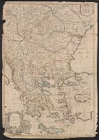
Dedicated to Arthur Charlett by John Senex and John Maxwell., Imperfect: mutilated, and torn along folds, with some loss of text; bottom portion of map detached. Ms. no. on verso: 26. Hand col. Sheet measures 68 x 98 cm. Cross Collection no. 101., and Relief shown pictorially.
Publisher:
John Senex,
Subject (Geographic):
Balkan Peninsula--Early works to 1800--Maps
Subject (Name):
Charlett, Arthur, dedicatee, Maxwell, John, fl. 1708-1711, dedicator, and Senex, John, d. 1740. New general atlas
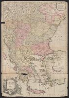
Dated from other maps in the atlas., Decorative title cartouche with classical figures., From Senex's A new general atlas ... London: Printed for Daniel Browne ... [etc.], 1721., Imperfect: mutilated, and torn along folds, with some loss of text. Ms. no. on verso: 26. Hand col. Sheet measures 68 x 98 cm. Cross Collection no. 100., and London meridian.
Publisher:
John Senex,
Subject (Geographic):
Balkan Peninsula--Early works to 1800--Maps
Subject (Name):
Charlett, Arthur, dedicatee, Maxwell, John, fl. 1708-1711, dedicator, and Senex, John, d. 1740. New general atlas
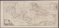
Cross Collection no., From The political magazine (March 1780), v. 1, opposite p. 179., Includes inset map: The Harbour & Fort of Omoa., Mounted on linen., and Scales in British statute miles (69 to a degree) and British marine leagues.
Publisher:
s.n.,
Subject (Geographic):
Caribbean Area--Maps--Early works to 1800, Central America--Maps--Early works to 1800, and Omoa (Cortés, Honduras)--Maps--Early works to 1800
Subject (Topic):
Harbors--Honduras--Omoa--Maps--Early works to 1800
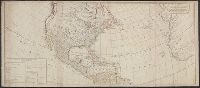
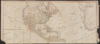
Includes table of "The continent and islands of America are divided and possessed as follows viz." and May be part of a map attributed to R. Sayer, based on maps by d'Anville and materials by Thomas Pownall; first issued in 1763 by J. Gibson and reissued over
Publisher:
s.n.,
Subject (Geographic):
America--Maps--Early works to 1800 and North America--Maps--Early works to 1800
Subject (Name):
Anville, Jean Baptiste Bourguignon d', 1697-1782, Gibson, J. (John), and Pownall, Thomas, 1722-1805
Includes table of "The continent and islands of America are divided and possessed as follows viz.", Prime meridian: Ferro., and Probably part of a map attributed to R. Sayer, based on maps by d'Anville and materials by Thomas Pownall; first issued in 1763 by J.
Publisher:
s.n.,
Subject (Geographic):
America--Maps--Early works to 1800 and North America--Maps--Early works to 1800
Subject (Name):
Anville, Jean Baptiste Bourguignon d', 1697-1782, Gibson, J. (John), and Pownall, Thomas, 1722-1805
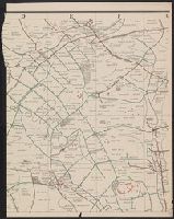
In upper right corner: Gent. Mag., Prime meridian: London., Relief shown pictorially and with hachures., Removed from: Gentleman's magazine. [June 1763]., Sheet measures 20.4 x 26.9 cm. Cross Collection no. 186., and Shows locations of North American Indian tribes.
Publisher:
Gentleman's Magazine,
Subject (Geographic):
Mississippi River Valley--Maps--Early works to 1800 and North America--Maps--Early works to 1800
Subject (Topic):
Indians of North America--Maps--Early works to 1800