Skip to search
Skip to main content
Skip to first result
Search
You Searched For
Format
cartographic
Publication Place
[Washington] :
New Search
Search Results
Published / Created:
[1944?]
Call Number:
307hc 1944
Container / Volume:
BRBL_00036A
Image Count:
1
Resource Type:
Maps, Atlases & Globes
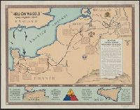
Description:
Inset: North African and Sicilian campaigns.
Publisher:
G-2 Section, 2nd A.D.,
Subject (Geographic):
Europe, Western--Maps
Found in:
Beinecke Rare Book and Manuscript Library > "Hell on Wheels" 1942-1943-1944.
Creator:
Published / Created:
[1851?]
Call Number:
74cea 1851
Container / Volume:
BRBL_00394
Image Count:
1
Resource Type:
Maps, Atlases & Globes
Alternative Title:
American Arctic expedition in search of Sir John Franklin.
Description:
Depths shown by soundings. and Includes notes.
Publisher:
United States Hydrographic Office,
Subject (Geographic):
Arctic regions--Discovery and exploration--Maps and Northwest Passage--Discovery and exploration--Maps
Subject (Name):
Franklin, John,--Sir,--1786-1847
Found in:
Beinecke Rare Book and Manuscript Library > A chart illustrative of the cruise of the American Arctic expedition in search of Sir John Franklin, in the years 1850 & 1851.
Published / Created:
1863-1864.
Call Number:
75cea 1864
Container / Volume:
BRBL_00409
Image Count:
2
Resource Type:
Maps, Atlases & Globes
Description:
Imperfect: Sheets 3-4 wanting. and Sheet No. 1, Cape Sable to Sandy Hook ; Sheet No. 2, Nantucket to Cape Hatteras ; Sheet No. 3, Cape Hatteras to Mosquito Inlet ; Sheet No. 4, Mosquito Inlet to Key West.
Publisher:
U.S. Coast Survey,
Subject (Geographic):
United States--Maps
Found in:
Beinecke Rare Book and Manuscript Library > Atlantic Coast of the United States (in four sheets).
Creator:
Published / Created:
1944
Call Number:
42gmb 1944
Container / Volume:
BRBL_00245
Image Count:
1
Resource Type:
Maps, Atlases & Globes
Description:
Indicates left- and right- hand driving zones and snow clearing., Map in German; legend and overlays in English., and Relief indicated by spot heights.
Publisher:
Lithographed in the Reproduction Branch, OSS,
Subject (Geographic):
Austria--Maps
Subject (Name):
United States. Office of Strategic Services. Reproduction Branch
Subject (Topic):
Roads--Austria--Maps and Snow removal--Austria--Maps
Found in:
Beinecke Rare Book and Manuscript Library > Austria [cartographic material] : Federal roads 1937.
Published / Created:
1849
Call Number:
771cea B98 1849
Container / Volume:
BRBL_00493
Image Count:
1
Resource Type:
Maps, Atlases & Globes
Publisher:
Coast Survey,
Subject (Geographic):
New York Harbor (N.Y. and N.J.)--Maps
Found in:
Beinecke Rare Book and Manuscript Library > B No.2 Sketch of Buttermilk Channel New York Harbor by the Hydrographic party of the Coast Survey ...
Creator:
Published / Created:
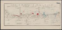
[1943]
Call Number:
382 1943
Container / Volume:
BRBL_00175
Image Count:
1
Resource Type:
Maps, Atlases & Globes
Description:
"22 November 1943.", "Map no. 2438.", and Relief shown by contours; depths shown by isolines.
Publisher:
Reproduction Branch, OSS,
Subject (Geographic):
Normandy (France)--Maps
Subject (Topic):
Beaches--France--Normandy--Maps
Found in:
Beinecke Rare Book and Manuscript Library > Beaches of Normandy - Vierville to Houlgate [cartographic material] / compiled and drawn in the Branch of Research and Analysis, OSS.
Creator:
Published / Created:
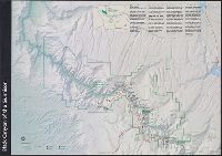
[2001]
Call Number:
834 B52 2001
Container / Volume:
BRBL_00589
Image Count:
2
Resource Type:
Maps, Atlases & Globes
Alternative Title:
Black Canyon of the Gunnison
Description:
"GPO: 2001--472-470/40037.", Includes area map and text., Panel title., Relief shown by shading and spot heights., and Text and col. ill. on verso.
Publisher:
The Service,
Subject (Geographic):
Black Canyon of the Gunnison National Park (Colo.)--Maps
Found in:
Beinecke Rare Book and Manuscript Library > Black Canyon of the Gunnison National Park, Colorado / National Park Service, U.S. Department of the Interior.
Creator:
Published / Created:
[1980]
Call Number:
836 B51 1980
Container / Volume:
BRBL_00592
Image Count:
2
Resource Type:
Maps, Atlases & Globes
Alternative Title:
Bryce Canyon offizieller Führer mit Karte
Description:
"*GPO: 1980--311-309/28.", Includes text and ancillary map of "Bryce Amphitheater trailheads.", Panel title: Bryce Canyon., Relief shown by shading and spot heights., and Text, cross section, and col. ill. on verso.
Publisher:
The Service,
Subject (Geographic):
Bryce Canyon National Park (Utah)--Maps
Found in:
Beinecke Rare Book and Manuscript Library > Bryce Canyon National Park, Utah / National Park Service, U.S. Department of the Interior.
Creator:
Published / Created:
1943
Call Number:
47gme 1943
Container / Volume:
BRBL_00261
Image Count:
1
Resource Type:
Maps, Atlases & Globes
Description:
"August 31, 1943". and Map no. 2567, supercedes Map no. 1479.
Publisher:
The Office,
Subject (Geographic):
Bulgaria--Maps
Found in:
Beinecke Rare Book and Manuscript Library > Bulgaria, railroads and railroad facilities [cartographic material] / compiled and drawn in the Branch of Research and Analysis, OSS.
Creator:
Published / Created:
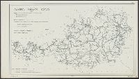
1934
Call Number:
844fb 1930
Container / Volume:
BRBL_00614
Image Count:
1
Resource Type:
Maps, Atlases & Globes
Publisher:
U.S. Govt. Print. Off.,
Subject (Geographic):
California--Administrative and political divisions--Maps
Found in:
Beinecke Rare Book and Manuscript Library > California : minor civil divisions / Bureau of the Census, 1930.
Branch:v1.61.8 ,Deployed:2024-06-20T11:15:04-04:00