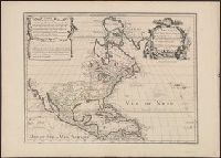
Bar scale given in "echelle de cent lieues Francoises"., Copy 3: Sh, Includes notes., Inset: Carte particuliere des embouchures de la riviere S. Louis et de la Mobile. Scale [ca. 1:2,700,000]., Relief shown pictorially., and Shows some explorers' routes.
Publisher:
Chez Jean Cóvens et Corneille Mortier, geographes,
Subject (Geographic):
Louisiana--Maps--Early works to 1800, Mississippi River Valley--Maps--Early works to 1800, and United States--Maps--Early works to 1800
Subject (Name):
Cóvens et Mortier. Atlas nouveau and Le Maire, François
Appears in the Cóvens et Mortier's Atlas nouveau, 1730 and later eds., Bar scale given in "echelle de cent lieues Francoises"., Copy 2: With watermark. Sheet measures 54.6 x 63.4 cm., and Inset: Carte particuliere des embouchures de la riviere S. Louis et de la
Publisher:
Chez Jean Cóvens et Corneille Mortier, geographes,
Subject (Geographic):
Louisiana--Maps--Early works to 1800, Mississippi River Valley--Maps--Early works to 1800, and United States--Maps--Early works to 1800
Subject (Name):
Cóvens et Mortier. Atlas nouveau and Le Maire, François
Appears in the Cóvens et Mortier's Atlas nouveau, 1730 and later eds., Bar scale given in "echelle de cent lieues Francoises"., Copy 1: Bookseller's label: Libreria Loescher e Co. ... Roma. Mounted on linen. Sheet measures 56.5 x 65.8 cm., and Covers eastern Un
Publisher:
Chez Jean Cóvens et Corneille Mortier, geographes,
Subject (Geographic):
Louisiana--Maps--Early works to 1800, Mississippi River Valley--Maps--Early works to 1800, and United States--Maps--Early works to 1800
Subject (Name):
Cóvens et Mortier. Atlas nouveau and Le Maire, François
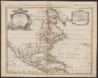
Originally L'Isle lived at the Rue des Canettes prez de St. Sulpice, in Paris; and the first issue of this map bears that location. About 1708 he moved to the address given on this map. Therefore, this map must have been issued in 1708 or later. See Map C
Publisher:
chez L. Renard Libraire, prz de la Bourse, and Chez l'Autheur sur le Quai de l'Horloge à la Courne. de Diamans ;
Subject (Geographic):
North America--Maps--Early works to 1800
Subject (Name):
Guérard, Nicolas, ca. 1648-1719 and Renard, Louis, b. ca. 1678
America Septentrionales in suas praecipus partes divisa, ad usum serenissimi Burgundiae Ducis
Description:
"Avec privilege.", Appeared in various eds. of Cóvens et Mortier's Atlas, Described in Mercator's world. Vol. 6, no. 6. Sept./Oct. 2001, p. 30., Includes eight bar scales., and Watermark. Stamp on verso: Yale, Horace Brown, 1900S. Sheet measures 50.5 x 63.2 cm.
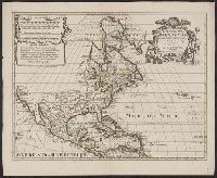
For history of map and earlier states, see P.D. Burden's Mapping of North America, no. 245., Includes "Avertissement.", Ms. title on verso. Label with ms. no. on verso: 101/63. Sheet measures 54.8 x 63 cm. Cross collection no. 144., and Relief shown pictorially.
Publisher:
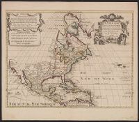
Chez R. & J. Ottens, geogrâphes dan le Kalverstraat au Carte du Monde,