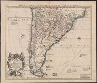
Tabula geographica Paragaiae, Chilis, Freti a Magellanici &c
Description:
Appears in Cóvens and Mortier's Atlas nouveau; cf. Koeman, C. Atlantes Neerlandici, II C & M 4., Bar scales given in "lieues marines d'Espagne" and "lieues comm. d'Espagne"., Cross Collection no. 327., Mounted in linen., Relief shown pictorially., and Shows southern part of South American continent.
"Avec privilege du 30 Av. 1745"., Imprint in lower left: "A Paris chez l'auteur ... ", Prime meridian: Ferro., Relief shown pictorially., and Watermarks. Sheet measures 54 x 72 cm. Manuscript note on verso: 30.
Publisher:
Ph. Buache ...
Subject (Geographic):
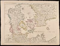
Denmark--Maps--Early works to 1800., Schleswig-Holstein (Germany)--Maps--Early works to 1800., and Sweden--Maps--Early works to 1800.
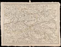
Postarum seu veredarum stationes per Germaniam et provincias adiacentes
Description:
Appeared in de L'Isle's Atlas noveau (1730 eds.); cf. Koeman C. Atlantes Neerlandici, II, C & M 3, map 19 and C & M 4, map 23., Bar scales given i, Variant without "par M. de l'Isle, geographe du Roy." Sheet measures 57.0 x 68.1 cm., and Verso blank.
Publisher:
Chez Iean Covens & Corneille Mortier,
Subject (Geographic):
Germany--Maps--Early works to 1800
Subject (Name):
Cóvens et Mortier and L'Isle, Guillaume de, 1675-1726. Atlas nouveau
"Avec privilege du 30 Av. 1745"., Prime meridian: Ferro., Relief shown pictorially., Shows forests, etc., and Watermark. Sheet measures 53 x 70 cm. Verso: "101" in manuscript.
Publisher:
Ph. Buache ...
Subject (Geographic):
Anjou (France)--Maps--Early works to 1800. and Touraine (France)--Maps--Early works to 1800.
L'Isle, Guillaume de, 1675-1726 Lotter, Tobias Conrad, 1717-1777
Published / Created:
176-?]
Call Number:
30 1720A
Container / Volume:
BRBL_00029
Image Count:
1
Resource Type:
Maps, Atlases & Globes
Description:
Cartouche with Apollo and Athena at bottom., Includes eight bar scales., Prime meridian: Ferro., Relief shown pictorially., and Sheet measures 48.5 x 61.6 cm.
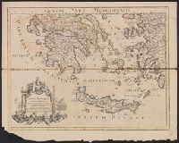
Graeciae pars meridionalis and Graeciae pars septentrionalis
Description:
Appears in Senex's Modern geography, or, All the known countries in the world ... [London]: For T. Bowles & T. Bowles & Son, [1708-1725], Imperfect: sheet "Graeciae pars meridionalis" detached at fold; sheet "Graeciae pars sept, and Relief shown by pictorially.
Publisher:
Prostant venales apud I. Senex ... ,
Subject (Geographic):
Crete (Greece)--Maps--Early works to 1800, Greece--History--Early works to 1800--Maps, Kyklades (Greece)--Maps--Early works to 1800, and Turkey--History--Early works to 1800--Maps
Subject (Name):
Senex, John, d. 1740. Modern geography, or, All the known countries in the world
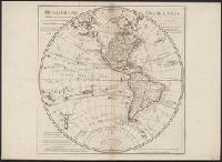
In lower right: Ph. Buache, P.G.d.R, d l'A.R.d.S. Gendre de l'auteur. Avec privilège du Roi., Library's copy stamped on backing: Yale University Library, Karpinski-Von Wieser Map Collection., and Relief shown pictorially.
Publisher:
Dezauche,
Subject (Geographic):
America--Discovery and exploration--Maps and Western Hemisphere--Maps
Subject (Name):
Buache, Philippe, 1700-1773, Cook, James--(1728-1779)--Travel--Maps, and Dezauche, J
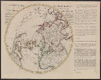
"Corrigée de nouveau sur la carte de Mr. Johannes Kyrilow ... ", Hand col. Lada-Mocarski Collection., Includes text of letter (in French and Dutch) written by "Monsieur Swartz ... a St. Petersbourg, and Title and place names in French. Text in French and Dutch.
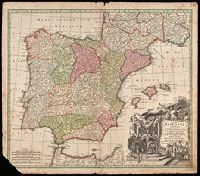
Five bar scales given., Imperfect: lower left corner chipped, with some loss of text. Manuscript number in upper right corner: 10. From the Karpinski-von Wieser Map Collection., Prime meridian: Ferro., and Relief shown pictorially.
Publisher:
[Matthaeus Seutter]
Subject (Geographic):
Iberian Peninsula--Maps--Early works to 1800
Subject (Name):
Méndez Silva, Rodrigo, 1607-1675 and Seutter, Matthaeus, 1678-1756
"Iohan. Senex scu, Imprint derived from other maps in the same atlas., London meridian., Ms. no. on verso: 34. Sheet measures 53 x 68 cm. Cross Collection no. 96., Relief shown pictorially., and Shows boundaries, forests, rivers, roads and settlements, with notes.
Publisher:
John Senex,
Subject (Geographic):
Mediterranean Region--Historical geography--Early works to 1800--Maps
Subject (Name):
Senex, John, d. 1740. New general atlas
Subject (Topic):
Ecclesiastical geography--Africa, North--Maps--Early works to 1800