Search
You Searched For
Search Results
- Creator:
- Dawes, William, 1762-1836
- Published / Created:
- 1791 March
- Call Number:
- DU170 H85+ Oversize
- Collection Title:
- An historical journal of the transactions at Port Jackson and Norfolk island, with the discoveries
- Image Count:
- 1
- Resource Type:
- Books, Journals & Pamphlets
- Subject (Geographic):
- New South Wales --History
- Subject (Name):
- Ball, Henry Lidgbird, King, Philip Gidley, 1758-1808, and Phillip, Arthur, 1738-1814
- Collection Created:
- London : J. Stockdale, 1793
- Found in:
- Beinecke Rare Book and Manuscript Library > A map of all those parts of the territory of New South Wales which have been seen by any person belonging to the settlement established at Port Jackson, in the said territory ...
- Creator:
- Moll, Herman, d. 1732
- Published / Created:
- [1732]
- Call Number:
- E1015 M66 1732
- Collection Title:
- Atlas minor: or a set of sixty-two new and correct maps, of all parts of the world. All composed
- Image Count:
- 1
- Description:
- Autograph of Gravely. Autograph of Baldock. Autograph of Aston. Autograph of W. Alington.
- Subject (Geographic):
- America--Maps--Early works to 1800
- Subject (Topic):
- Atlases--Early works to 1800
- Collection Created:
- London :
- Found in:
- Beinecke Rare Book and Manuscript Library > A map of the West-Indies & c. Mexico or New Spain. Also ye trade winds, and ye several tracts made by ye galeons and flota from place to place. By H. Moll geographer.
- Call Number:
- 1977 +392
- Collection Title:
- A survey of the cities of London and Westminster : containing the original, antiquity, increase
- Image Count:
- 1
- Resource Type:
- Maps, Atlases & Globes
- Description:
- Plate between p. 44-45.
- Subject (Geographic):
- London (England)--History
- Collection Created:
- London : Printed for A. Churchill, J. Knapton, R. Knaplock, J. Walthoe [and 6 others], 1720
- Found in:
- Beinecke Rare Book and Manuscript Library > A map of the parish if St. Katherines by the Tower
- Call Number:
- 1977 +392
- Collection Title:
- A survey of the cities of London and Westminster : containing the original, antiquity, increase
- Image Count:
- 1
- Resource Type:
- Maps, Atlases & Globes
- Description:
- Plate between p. 46-47.
- Subject (Geographic):
- London (England)--History
- Collection Created:
- London : Printed for A. Churchill, J. Knapton, R. Knaplock, J. Walthoe [and 6 others], 1720
- Found in:
- Beinecke Rare Book and Manuscript Library > A map of the parish of St. Dustans Stepney and Stebunheath divided into hamlets
- Call Number:
- 1977 +392
- Collection Title:
- A survey of the cities of London and Westminster : containing the original, antiquity, increase
- Image Count:
- 1
- Resource Type:
- Maps, Atlases & Globes
- Description:
- Plate between p. 108-109.
- Subject (Geographic):
- London (England)--History
- Collection Created:
- London : Printed for A. Churchill, J. Knapton, R. Knaplock, J. Walthoe [and 6 others], 1720
- Found in:
- Beinecke Rare Book and Manuscript Library > A mapp of the parishes of St. Clements Danes, St. Mary Savoy; with the Rolls Liberty and Lincolns Inn, taken from the last survey with corrections and additions
- Call Number:
- 1977 +392
- Collection Title:
- A survey of the cities of London and Westminster : containing the original, antiquity, increase
- Image Count:
- 1
- Resource Type:
- Maps, Atlases & Globes
- Description:
- Plate between p. 26-27.
- Subject (Geographic):
- London (England)--History
- Collection Created:
- London : Printed for A. Churchill, J. Knapton, R. Knaplock, J. Walthoe [and 6 others], 1720
- Found in:
- Beinecke Rare Book and Manuscript Library > A mapp of the parishes of St. Saviours Southwark and St. Georges taken from the last survey with corrections
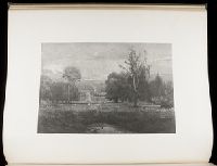
- Creator:
- Inness, George, 1825-1894
Kingsley, Elbridge, 1842-1918
- Call Number:
- Folio Shirley 11
- Collection Title:
- Engravings on wood : by members of the Society of American Wood-engravers / with an introduction
- Image Count:
- 1
- Subject (Topic):
- Wood-engraving, American
- Collection Created:
- New York : Harper and Brothers, 1887
- Found in:
- Beinecke Rare Book and Manuscript Library > A morning
- Published / Created:
- 1833
- Call Number:
- 2002 Folio 97
- Collection Title:
- Tanner’s universal atlas : subscription price $1.00 a number, seperate [sic] numbers $1.50 each
- Image Count:
- 1
- Resource Type:
- Maps, Atlases & Globes
- Alternative Title:
- II.-Map of the state of Maine
- Description:
- Plate identified as "II" on atlas cover and "5" on map. and Verso blank.
- Subject (Geographic):
- Maine
- Collection Created:
- Philadelphia : Published by the author, 1833-1836
- Found in:
- Beinecke Rare Book and Manuscript Library > A new map of Maine
- Published / Created:
- 1833
- Call Number:
- 1976 Folio 98
- Collection Title:
- A new universal atlas, containing maps of the various empires, kingdoms, states and republics of
- Image Count:
- 1
- Resource Type:
- Maps, Atlases & Globes
- Subject (Geographic):
- Maine
- Collection Created:
- Philadelphia, Published by the author, 1836
- Found in:
- Beinecke Rare Book and Manuscript Library > A new map of Maine
- Published / Created:
- 1850
- Call Number:
- 1976 Folio 96
- Collection Title:
- A new universal atlas containing maps of the various empires, kingdoms, states and republics of the
- Image Count:
- 1
- Resource Type:
- Maps, Atlases & Globes
- Publisher:
- Thomas, Cowperthwait & Co
- Subject (Geographic):
- Maine
- Collection Created:
- Philadelphia, Cowperthwait, DeSilver & Butler, 1854, c1850
- Found in:
- Beinecke Rare Book and Manuscript Library > A new map of Maine