Skip to search
Skip to main content
Skip to first result
Search
You Searched For
Genre
Intaglio prints
Genre
Maps
New Search
Search Results
Creator:
Call Number:
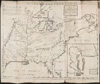
Vanderbilt 147
Collection Title:
An historical account of the expedition against the Ohio Indians, in the year 1764. Under the
Image Count:
1
Alternative Title:
A Topographical plan of that part of the Indian country thro
Description:
Between p. 32 & p. 33.
Subject (Geographic):
Fort Pitt (Pa.) --History, Ohio River Valley --History --Revolution, 1775-1783, and Pennsylvania --History
Subject (Name):
Bouquet, Henry, 1719-1765
Subject (Topic):
Bouqet’s Expedition, 1764, Bushy Run, Battle of, Pa., 1763, Indians of North America --Wars --1750-1815, and Indians --Warfare
Collection Created:
Philadelphia, Printed and sold by W. Bradford, 1765
Found in:
Beinecke Rare Book and Manuscript Library > A General map of the country on the Ohio and Mushkingham shewing the situation of the Indian-towns with respect to the army under the command of Colonel Bouquet by Thos. Hutchins. Asst. Engineer
Creator:
Published / Created:
February the 2d, 1756.
Call Number:
771hc H864 1756
Container / Volume:
BRBL_00495
Image Count:
1
Resource Type:
Maps, Atlases & Globes
Abstract:
Subject: Map of Hudson River from New York City to Lake George, with plans of Fort Edward and Fort William Henry. Also includes views of the first and second engagements during the Battle of Lake George. In the "First engagement" soldiers are seen shootin
Description:
771hc H864 1756: Stamp "Yale Horace Brown 1900S." Accompanied by reproduction of map [with stamp "Yale Horace Brown 1900S"]. and Coordinates not present on map of Hudson River and are approximated.
Publisher:
Published according to act of Parliament,
Subject (Geographic):
Hudson River (N.Y. and N.J.)--Maps, New York (State)--Lake George, United States--History--French and Indian War, 1754-1763--Campaigns--Pictorial works, and United States--Hudson River
Subject (Name):
Brown, Horace--Stamp, French and Indian War (United States : 1754-1763), Jefferys, Thomas, -1771, engraver, and Lake George, Battle of (New York : 1755)
Subject (Topic):
Lake George, Battle of, N.Y., 1755--Pictorial works
Found in:
Beinecke Rare Book and Manuscript Library > A Prospective view of the battle fought near Lake George, on the 8th of Sepr. 1755 : between 2000 English, with 250 Mohawks, under the command of Gen. Johnson: & 2500 French & indians under the command of Genl. Dieskau in which the English were victorious
Call Number:
Egi M6 722
Collection Title:
A description of the English province of Carolana, by the Spaniards call'd Florida, and by the
Image Count:
1
Alternative Title:
Inset map of the Mouth of the River Meshacebe
Description:
Preceding p. 1. and Teaching resource: Professor John Mack Faragher, History 141: The American West.
Subject (Geographic):
Florida --Description and travel, Louisiana --Description and travel --Early works to 1800, and Mississippi River Valley --Description and travel
Collection Created:
London, Printed for B. Cowse, 1722
Found in:
Beinecke Rare Book and Manuscript Library > A map of Carolana and of the River Meschacebe & c.
Published / Created:
1833
Call Number:
2002 Folio 97
Collection Title:
Tanner’s universal atlas : subscription price $1.00 a number, seperate [sic] numbers $1.50 each
Image Count:
1
Resource Type:
Maps, Atlases & Globes
Alternative Title:
II.-Map of the state of Maine
Description:
Plate identified as "II" on atlas cover and "5" on map. and Verso blank.
Subject (Geographic):
Maine
Collection Created:
Philadelphia : Published by the author, 1833-1836
Found in:
Beinecke Rare Book and Manuscript Library > A new map of Maine
Call Number:
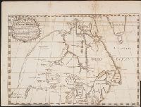
Zc90 +744do
Collection Title:
An account of the countries adjoining to Hudson's Bay, in the North-west part of America
Image Count:
1
Description:
Preceding title page. and Teaching resource: Professor John Mack Faragher, History 141: The American West.
Subject (Geographic):
Great Lakes (North America), Northwest Coast of North America, Northwest Passage, and Northwest, Canadian --Description and travel
Subject (Name):
Fuentes, Bartolome de, 17th cent, Hudson’s Bay Company, and Middleton, Christopher, d. 1770
Subject (Topic):
Fur trade --Canada and Indians of North America --Canada
Collection Created:
London : Printed for J. Robinson, 1744
Found in:
Beinecke Rare Book and Manuscript Library > A new map of part of North America from the latitude of 40 to 68 degrees. Including the late discoveries made on board the Furnace Bomb Ketch in 1742. And the western rivers & lakes falling into Nelson River in Hudson's Bay, as described by Joseph La Fran
Creator:
Published / Created:
[1794?]
Call Number:
EEa 794b
Image Count:
1128
Resource Type:
Books, Journals & Pamphlets
Description:
Autograph of N.B. Haswell., Irregularities in paging 1 map (Europe) wanting., and Many of the plates dated 1794.
Publisher:
Sold by A. Hogg
Subject (Name):
Haswell, N.B.--Autograph., Hogg, Henry., Outlon, Clement Walley., and Robertson, Charles Andrew.
Subject (Topic):
Geography.
Found in:
Beinecke Rare Book and Manuscript Library > A new, royal, authentic, complete, and universal system of geography: or, A modern history and description of the whole world. Containing ... accounts and descriptions of Europe, Asia, Africa, and America ... including the substance and essence of the most remarkable voyages and travels ... particularly the late discoveries in the South seas, and towards the North pole ... Comprising every interesting discovery and circumstance in the narratives of Captain Cook's voyages round the world. Together with all the recent discoveries ... carefully written and compiled from the late journals of ... Captains Phillips, King, Ball, Hunter, White, Dixon, Portlock, Mears, Patterson, Bruce, Anbury, Rochon, Morse, Blyth, Ross, Imlay, Keate, Brissot, Hodges, &c. &c. Also compendious histories of every empire, kingdom, state, &c. ... The whole embellished and enriched with upwards of an hundred most elegant and superb copperplates ... By George Augustus Baldwyn, esq. assisted by many gentlemen eminent for their knowledge ... of geography; particularly Charles Andres Robertson, esq.--Clement Walley Oulton. esq.-- and Henry Hogg ...
Call Number:
CF2041 +L54
Collection Title:
A true & exact history of the island of Barbados. Illustrated with a mapp of the island, as also
Image Count:
1
Resource Type:
Maps, Atlases & Globes
Description:
Verso blank.
Subject (Geographic):
Barbados --Description and travel and Barbados --Maps --Early works to 1800
Collection Created:
London, Printed for H. Moseley, 1657
Found in:
Beinecke Rare Book and Manuscript Library > A topographicall description and admeasurement of the yland of Barbados in the West Indyaes with the m.rs names of the seuerall plantacons
Creator:
Published / Created:
1631
Call Number:
Taylor 316
Image Count:
2
Alternative Title:
New England: the most remarqueable parts thus named by the high and mighty Prince Charles, nowe King of great Britaine [map] and Path-way to experience to erect a plantation.
Description:
Imperfect: damp-stained; added port. of Charles I., Map with portrait of Capt. Smith in corner: New England ... / observed and described by Captayn John Smith. 1614. Pendleton's Lithography, Boston. Drawn by J. Eddy. London, printed by Geor: Low., Signatures: A-F⁴., and Teaching resource: Professor John Mack Faragher, History 141: The American West.
Publisher:
Printed by I. Haviland, and are to be sold by R. Milbovrne,
Subject (Geographic):
Massachusetts--History--Colonial period, ca. 1600-1775, Massachusetts--Maps--Early works to 1800, New England--Description and travel, New England--History--Colonial period, ca. 1600-1775, and New England--Maps--Early works to 1800
Subject (Name):
Pasaeus, Simon and Reeve, James
Found in:
Beinecke Rare Book and Manuscript Library > Advertisements for the unexperienced planters of New-England, or anywhere, or, The path-way to experience to erect a plantation : With the yearely proceedings of this country in fishing and planting, since the yeare 1614. to the yeare 1630. and their present estate. Also how to prevent the greatest inconveniences, by their proceedings in Virginia, and other plantations, by approved examples. With the countries armes, a description of the coast, harbours, habitations, land-markes, latitude and longitude: with the map, allowed by our royall King Charles. By Captaine Iohn Smith, sometimes governour of Virginia, and admirall of Nevv-England.
Call Number:
Ck3 35p
Collection Title:
Missive van William Penn ... : Geschreven aan de commissarissen van de Vrye Societeyt der
Image Count:
1
Description:
Facing p. 22.
Subject (Geographic):
Pennsylvania --Description and travel and Philadelphia (Pa.) --Description and travel
Subject (Name):
Holme, Thomas, d. 1695 and Paschall, Thomas, 1634-1718. Abstract of a letter. Dutch
Subject (Topic):
Indians --Pennsylvania
Collection Created:
Amsterdam : J. Claus, 1684
Found in:
Beinecke Rare Book and Manuscript Library > Afteykeninge van de Stadt Philadelphia in de Provinstie van Penn-sylvania in Americae na de Copie tot London. en intneder duyts laeten Snyden door Jacob Claus
Published / Created:
Undated
Call Number:
Taylor 355
Collection Title:
America painted to the life. The true history of the Spaniards proceedings in the conquests of the
Image Count:
1
Description:
Preceding p. 1. and Teaching resource: Professor John Mack Faragher, History 141: The American West.
Subject (Geographic):
America --Discovery and exploration and North America --Maps --Early works to 1800
Collection Created:
London, Printed for Nath. Brook at the Angel in Cornhil, 1658-59
Found in:
Beinecke Rare Book and Manuscript Library > Americae descrip
Branch:v1.61.6 ,Deployed:2024-06-12T09:55:31-04:00