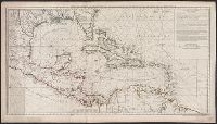
"4 e. feuille.", "No. 5" in lower right corner., Prime meridian: Paris., Relief shown pictorially. Depths shown by soundings., Shows English ownership of Florida., and Stamped no. "107" and title "Golfe du Mexique" on verso. Cross Collection no. 246.
Publisher:
Sur ley Quay de la Megisserie prés le Pont Neuf ...,
Subject (Geographic):
Caribbean Area--Maps--Early works to 1800
Subject (Name):
Buache, Philippe, 1700-1773. Atlas géographique et universel, L'Isle, Guillaume de, 1675-1726. Atlas géographique et universel, and Popple, Henry, -1743
Subject (Topic):
Nautical charts--Caribbean Area--Early works to 1800
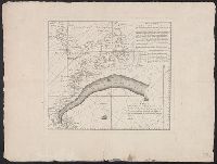
Hand col. Mounted on linen. Sheet measures 65 x 49 cm. Ms. n, Has watermarks., Includes index and ill., Oriented with north to the bottom., Relief shown by hachures. Depths shown by soundings., and Shows fortifications and coastal defenses in the Gibraltar region.
Publisher:
Chez Basset, rue St. Jacques, au coin de delle des Mathurins,
Subject (Geographic):
Gibraltar, Bay of (Spain)--Maps--Early works to 1800
Subject (Name):
Coquart, A
Subject (Topic):
Coast defenses--Spain--Gibraltar, Bay of--Maps--Early works to 1800 and Fortification--Spain--Gibraltar, Bay of--Maps--Early works to 1800
Described as an untitled French translation of an unknown Mount and Page chart annotated by Benjamin Franklin in preparation for publication in London in De Vorsey's Imago mundi article. and Includes text, shows latitude and longitude figures in right and bot
Publisher:
Chéz Le Rouge, rue des Grands Augustine ...,
Subject (Geographic):
Gulf Stream--Maps--Early works to 1800
Subject (Name):
Franklin, Benjamin, 1706-1790
Subject (Topic):
Nautical charts--Atlantic Coast (North America)--Early works to 1800