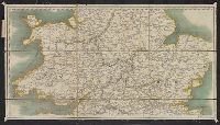
From La Rochefoucauld-Liancourt's Voyage dans les Etats Unis d'Amerique fait en 1795, 1796 et 1797. Paris : Chez Du Pont ... Buisson ... Charles Pougens ..., [1799], Relief shown by hachures., Sheet measures 43 x 46 cm., and Title in French and place
Publisher:
Chez Du Pont, Imprimeur-Libraire ...,
Subject (Geographic):
United States--Maps--Early works to 1800
Subject (Name):
La Rochefoucauld-Liancourt, François-Alexandre-Frédéric, duc de, 1747-1827. Voyage dans les Etats Unis d'Amerique fait en 1795, 1796 et 1797
La Pérouse, Jean-François de Galaup, comte de, 1741-1788
Published / Created:
{1797]
Call Number:
845 1797
Container / Volume:
BRBL_00619
Image Count:
1
Resource Type:
Maps, Atlases & Globes
Description:
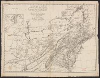
Appears in the author's Atlas du voyage de La Pérouse. 1797., Has watermark., In bottom right margin: no 16., Prime meridian: Paris., and Relief shown by hachures.
Publisher:
L'imprimerie de la république,
Subject (Geographic):
Northwest Coast of North America--Maps--Early works to 1800
Subject (Name):
Arnold, Robert M.--Ownership, Bouclet, Hérault, La Pérouse, Jean-François de Galaup, comte de, 1741-1788. Atlas du voyage de La Pérouse, and Le Paute d'Agelet, Joseph, 1751-ca. 1786
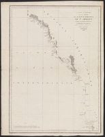
Above neat line: Pl. 4e. Campagne de 1802, Tome 2e., Cross Collection no. 273., From Mathieu Dumas's Précis des événemens militaires ... Paris ... : Treuttel et Würtz ..., 1816-1826., and Relief shown by hachures.
Publisher:
s.n.,
Subject (Geographic):
Hispaniola--Maps
Subject (Name):
Dumas, Mathieu, comte, 1753-1837. Précis des événemens militaires
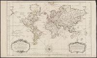
"No. 66" in upper right corner., Cross Collection no. 256., Depths shown by soundings., Inset: Carte des embouchures du fleuve St. Louis., Prime meridian: Paris., and Relief shown pictorially.
Publisher:
s.n.],
Subject (Geographic):
Gulf Coast (Fla.)--Maps--Early works to 1800
Subject (Name):
France. Dépôt des cartes et plans de la marine
Subject (Topic):
Coasts--Gulf States--Maps--Early works to 1800 and Coasts--Louisiana--Maps--Early works to 1800
At bottom of the title cartouche: "Par le S.r Bellin, Ingenieur de la Marine and New Guinea shown joined to New Holland; Dampier's Strait marked. Bellin traces the 'hypothetical' coast of New Holland which was object of speculation before Cook's discoveries.