Skip to search
Skip to main content
Skip to first result
Search
You Searched For
Genre
Maps
Language
German
Publication Place
Gotha :
New Search
Search Results
Published / Created:
1834
Call Number:
56cea 1834
Container / Volume:
BRBL_00298
Image Count:
1
Resource Type:
Maps, Atlases & Globes
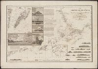
Description:
Insets: Macao, Harlems Bai, Views.
Publisher:
J. Perthes,
Subject (Geographic):
China--Maps
Found in:
Beinecke Rare Book and Manuscript Library > Die Chinesischen Küste ... Berghaus. Gest. V. H. Herzberg, Berlin.
Creator:
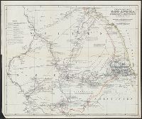
Published / Created:
1861
Call Number:
63 1861
Container / Volume:
BRBL_00334
Image Count:
1
Resource Type:
Maps, Atlases & Globes
Alternative Title:
Ost-Afrika zwischen Chartúm & dem Rothen Meere
Description:
Includes text., Prime meridians: Paris and Greenwich., and Relief shown by hachures.
Publisher:
Justus Perthes,
Subject (Geographic):
Eritrea--Discovery and exploration--Maps, Ethiopia--Discovery and exploration--Maps, and Sudan--Discovery and exploration--Maps
Subject (Name):
Heuglin, Theodor von,--1824-1876 and Justus Perthes (Firm : Gotha, Germany)
Found in:
Beinecke Rare Book and Manuscript Library > Entwurf einer Karte von Ost-Afrika zwischen Chartúm & dem Rothen Meere, bis Sauakin und Massaua : nach allen vorhandenen Quellen entworfen von A. Petermann, zum Gebrauch der v. Heuglin'schen Expedition ausgeführt durch Justus Perthes' Geographisches Ans
Published / Created:
1878
Call Number:
30 1878
Container / Volume:
BRBL_00032
Image Count:
1
Resource Type:
Maps, Atlases & Globes
Description:
Insets: Mt. Blanc and der Kasbeck with environs.
Publisher:
Justus Perthes,
Subject (Geographic):
Europe--Maps
Found in:
Beinecke Rare Book and Manuscript Library > Europa / Von A. Pertermann.
Published / Created:
1872
Call Number:
30ed 1872
Container / Volume:
BRBL_00037B
Image Count:
1
Resource Type:
Maps, Atlases & Globes
Publisher:
Justus Perthes,
Subject (Geographic):
Europe--Maps
Found in:
Beinecke Rare Book and Manuscript Library > Europa nach seinen Ethnographischen Verhaltnissen in der Mitte des XIX Jahrhunderts / Von Th. Menke. B.H. rev.
Creator:
Published / Created:
1864
Call Number:
352 1864
Container / Volume:
BRBL_00105
Image Count:
2
Resource Type:
Maps, Atlases & Globes
Alternative Title:
Stielers Hand-Atlas. and Südliches Blatt vom Europ. Russland
Description:
Stielers Hand-Atlas No. 37b -- Stielers Hand-Atlas No. 37c.
Publisher:
Justus Perthes,
Subject (Geographic):
Russia--Maps
Found in:
Beinecke Rare Book and Manuscript Library > Europäisches Russland / nach Ad. St.'s Entwurf in zwey Blatt gez. v. Fr. v. Stülpnagel.
Creator:
Published / Created:
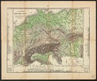
1875
Call Number:
36cbf 1875
Container / Volume:
BRBL_00127
Image Count:
1
Resource Type:
Maps, Atlases & Globes
Description:
Includes mountain range profiles showing heights of selected peaks in margin. and Relief shown by hachures and gradient tints.
Publisher:
Justus Perthes,
Subject (Geographic):
Europe--Maps and Germany--Maps
Subject (Name):
Berghaus, Hermann, 1828-1890 and Justus Perthes (Firm : Gotha, Germany)
Subject (Topic):
Mountains--Europe--Charts, diagrams, etc and Mountains--Germany--Charts, diagrams, etc
Found in:
Beinecke Rare Book and Manuscript Library > Fluss- und Bergkarte von Deutschland und den anliegenden Ländern / entworfen u. gez. von Adolf Stieler, 1820.
Creator:
Published / Created:
1904
Call Number:
38 1904
Container / Volume:
BRBL_00155
Image Count:
1
Resource Type:
Maps, Atlases & Globes
Description:
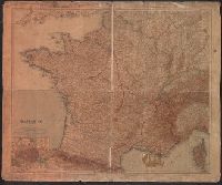
"Stielers Hand Atlas"., Inset maps: Paris und Umgebung. Scale 1:150,000 -- Corse = Corsica. Scale 1:1,500,000., and Relief shown by hachures and spot heights.
Publisher:
Justus Perthes,
Subject (Geographic):
France--Maps
Subject (Name):
Justus Perthes (Firm : Gotha, Germany)
Found in:
Beinecke Rare Book and Manuscript Library > Frankreich in 4 Blättern [cartographic material] / von C. Vogel ; gestochen, Schrift von H. Eberhardt, Terrain von W. Weiler.
Published / Created:
1836
Call Number:
59 1836A
Container / Volume:
BRBL_00317
Image Count:
1
Resource Type:
Maps, Atlases & Globes
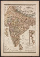
Description:
Insets: Mouth of the Indus; Assam and Arakan.
Publisher:
J. Perthes,
Subject (Geographic):
India--Maps
Found in:
Beinecke Rare Book and Manuscript Library > General Karte von Vorderindien ... Berghaus. A. Schmidt Sc. Berlin.
Published / Created:
1823
Call Number:
36 G712 1823
Container / Volume:
BRBL_00124
Image Count:
1
Resource Type:
Maps, Atlases & Globes
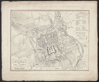
Publisher:
Justus Perthes,
Subject (Geographic):
Germany--Maps
Found in:
Beinecke Rare Book and Manuscript Library > Grundriss der Herzog Residenzstadt Gotha und deren Umgebung ... Gest. v. E.G. Edler. Entw. v. gez. v. I.C. Bär.
Published / Created:
1832
Call Number:
58 1832A
Container / Volume:
BRBL_00313
Image Count:
1
Resource Type:
Maps, Atlases & Globes
Description:
Birma, Siam, Indi-China, Malay Pen., sections of China & India.
Publisher:
J. Perthes,
Subject (Geographic):
East Asia--Maps
Found in:
Beinecke Rare Book and Manuscript Library > Hinterindien ... Berghaus. Gest. V.W. Brose, Berlin.
Branch:v1.61.8 ,Deployed:2024-06-20T11:15:04-04:00