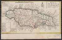
Appears on sheet Die Englische Colonie-Laender ... [Nürnberg] : Homaennische Erben, [ca. 1740], with, Cross Collection no. 282., Relief shown pictorially., and Title in Latin, explanations in German, and map locations in English.
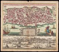
Lisabon die prächtigste Königl. Residenz Statt in Portugall u. florisanteste Handels Plaz am Austfluss des Tagi
Description:
"Cum gratia et privil. S.R.I. Vicariatus in partibus Rheni, Suevice, et Juris Franconici.", Historiated cartouche with note., Includes aerial view of "Lisabon" at bottom., and Manuscript number in upper right corner. From the Karpinski-von Wieser Map Collection.
Publisher:
[Matthaeus Seutter]
Subject (Geographic):
Lisbon (Portugal)--Aerial views--Early works to 1800, Lisbon (Portugal)--Maps--Early works to 1800, and Portugal--Lisbon
Guessefeld, F. L. (Franz Ludwig), 1744-1807 Homann Erben (Firm)
Published / Created:
1775
Call Number:
1983 Folio 23
Collection Title:
[Atlas factice of 50 maps, primarily by Johann Baptist Homann and/or issued by the Homann Erben
Image Count:
1
Publisher:
Impensis Homannianorum Haeredum
Subject (Geographic):
Bohemia (Czech Republic) --Maps --Early works to 1800, Galicia (Poland and Ukraine) --Maps --Early works to 1800, and Ukraine --Maps --Early works to 1800
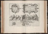
Mappa Aestivarvm insularum, alias Barmvdas dictarum
Description:
Below map, list of proprietors in 12 columns flanked by coats-of-arms., Borders are hand colored., and Not hand colored. With watermark. Sheet measures 46 x 55 cm.
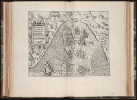
Charte worauf in einem Begriff und Anblick alle natürliche politische und Kunst-termini oder Wörter benen̄et.
Description:
1an, Demonstrates cartographic terms, symbols, depictions of landforms, etc., Has watermark., Relief shown pictorially., and Title in upper margin: Charte worauf in einem Begriff und Anblick alle natürliche politische und Kunst-termini oder Wörter benen̄et ...
Publisher:
Matthaeo Seutter,
Subject (Topic):
Cartography--Germany, Cartography--Methodology--Maps, Imaginary places--Maps--Early works to 1800, Maps--Symbols, and Maps--Terminology
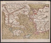
Noua Graecia, secundum omnes eius regiones & prouincias citra & ultra Hellespontum, Noua Graecia, secundum omnes eius regiones et prouincias citra et ultra Hellespontum, and Nova Graecia, secundum omnes eius regiones & provincias citra & ultra Hellespontum
Description:
Appears in the author's Cosmographiae uniuersalis. 1550., Hand col. Sheet measures 31 x 37 cm. Lanman Collection., Latin and German., and Relief shown pictorially.
Publisher:
s.n.,
Subject (Geographic):
Aegean Islands (Greece and Turkey)--Maps--Early works to 1800, Greece--Maps--Early works to 1800, and Turkey--Maps--Early works to 1800
From Blaeu's Novus atlas ... Amsterdami : Apud Guiljelmum Blaeuw, 1635., Oriented west., Relief shown pictorially., Upper left: Portait of Powhatan with subtitle: Status regis Powhatan quando prefectus Smith Captivus illi daretur., Upper right: Key to symbols., and Verso in German, with running title "Landschafft Virginia" and signature "B".
Publisher:
Ex Officina Guiljelmi Blaeuw,
Subject (Geographic):
Virginia--Maps--Early works to 1800
Subject (Name):
Blaeu, Willem Janszoon, 1571-1638. Theatrum orbis terrarum. German, Gryp, Dirck, engraver, Powhatan, ca. 1550-1618, and Smith, John, 1580-1631
Subject (Topic):
Powhatan Indians--Pictorial works--Early works to 1800
Abbildung der neuen russischen Haupt-Residenz und See Statt St. Petersburg., Neue Abbildung von der Situation der Statt St. Petersburg., and Neue u: accurate Abbildung der von dem grossen russ. Kaiser Petro Alexiewiz ao. 1703 an dem Aussfl. dess Neva Stroms erb
Description:
Abbildung der neuen russischen Haupt-Residenz und See Statt St. Petersburg -- Neue Abbildung von der Situation der Statt St. Petersburg., Includes text, index to selected buildings, and decorative cartouches., Latin and German., and Relief shown pictorially.
Publisher:
M. Seutter,
Subject (Geographic):
Neva River Watershed (Russia)--Maps--Early works to 1800, Saint Petersburg (Russia)--Maps--Early works to 1800, and Saint Petersburg Region (Russia)--Maps--Early works to 1800