Anville, Jean Baptiste Bourguignon d', 1697-1782, cartographer
Published / Created:
[1767]
Call Number:
50 1767
Container / Volume:
BRBL_00271
Image Count:
1
Resource Type:
Maps, Atlases & Globes
Description:
Cartographer and publication date from dealer's notes., Country labels in French., Inset: Supplement pour l'Asie et l'Afrique., Relief shown pictorially., Shows most of the Middle East, and part of Egypt., Stamp on verso: 27., and Watermark.
Publisher:
[publisher not identified],
Subject (Geographic):
Middle East--Maps--Early works to 1800, Palestine--History--To 70 A.D.--Maps--Early works to 1800, and Palestine--Maps--Early works to 1800
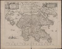
Coordinates not present on map and are approximated., Includes four bar scales., Relief shown pictorially., Verso blank., and Watermark. Manuscript number in upper left corner: 31. Manuscript annotation at top: Thebo.
Publisher:
[Jan Jansson],
Subject (Geographic):
Peloponnesus (Greece : Peninsula)--Maps--Early works to 1800.
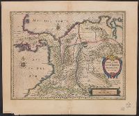
Bar scales in "Milliaria Gallica communia," "Leucae Hispanicae," and "Milliaria Germanica communia.", Cross Collection no. 355., From Blaeu's Le theatre du monde ... Amsterdami : Apud Guiljelmum et Iohannem Blaeu, 1635., In French on verso, with caption title "Chili" and signature 7N., Oriented with north to the left., and Relief shown pictorially.
Publisher:
Guiljelmus Blaeuw excudit,
Subject (Geographic):
Peru--Maps--Early works to 1800
Subject (Name):
Blaeu, Joan, 1596-1673. Theatrum orbis terrarum. French and Blaeu, Willem Janszoon, 1571-1638. Theatrum orbis terrarum. French
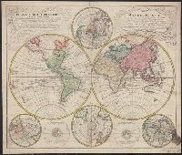
Mappe-monde qui représente les deux hemisphères savoir celui de l'orient et celui de l'occident, tirée des quatre cartes générales de feu M. le profess. Hasius, Planiglobii terrestris mappa vniversalis, and Schul-Atlas von zwantzig General- und Special-Lan
Description:
Appears in Homann heirs' Schul-atlas von zwantzig general-und special-land karten ... Cf. Phillips, no. 293., Imperfect: torn along fold, with no loss of text. Shee, Map colored to show distribution of religions., and Title in Latin and French; legend in German.
Publisher:
Homann Erben],
Subject (Name):
Hase, Johann Matthias, 1684-1742 and Homann Erben (Firm)
Subject (Topic):
Religion--Maps--Early works to 1800 and World maps--Early works to 1800
Lowitz, G. M. (George Moritz), 1722-1774, cartographer.
Call Number:
11 1746A
Image Count:
1
Resource Type:
Maps, Atlases & Globes
Alternative Title:
Mappe-monde qui représente les deux hemisphères savoir celui de l'orient et celui de l'occident, tirée des quatre cartes générales de feu M. le profess. Hasius and Planiglobii terrestris mappa vniversalis
Description:
Includes color illustrations, 4 ancillary maps showing poles, and 2 diagrams., Map colored to show distribution of religions., Mounted on linen. Sheet measures 49 x 61 cm. Cross collection no. 39., Relief shown pictorially., Title in Latin and French., and Variant with privilege statement "Cum Priv. S. Caes .Maj." in Latin cartouche and "Avec Priv. de S. Maj. Imper." in French cartouche, Fig. I, Fig. III, and Fig. IV. centered in the French cartouche, and with a detailed outline of Alaska and the Aleutian Archipelago.
Subject (Name):
Hase, Johann Matthias, 1684-1742. and Homann Erben (Firm), publisher.
Subject (Topic):
Religion--Maps--Early works to 1800. and World maps--Early works to 1800.
Dedicated to Czar Michaeli Foedrowits "ab Hesselo Gerardo, M.DC.XIII.", From : "Le theatre dv monde ou novvel atlas." By Iohannem and Guiljelmi F. Blaeu., Inset ma, Latin, with French text on verso: "Moscovie, ov la Rvssie blanche.", and Relief shown pictorially.
Publisher:
[Apud Iohannem] et Guiljelmum Blaeu,
Subject (Geographic):
Moscow (Russia)--Maps--Early works to 1800 and Russia--Maps--Early works to 1800
Subject (Name):
Blaeu, Willem Janszoon, 1571-1638. Theatrum orbis terrarum. French and Gerritsz., Hessel, 1581?-1632
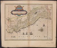
Carte generale de la Tartarie chinoise et des royaumes de Corée et de Iapan
Description:
French alternate title only., Imperfect: western sheet (with cartouche) wanting. Sheet measures 54 x 54 cm, with watermark., Includes text and ill., and Relief shown pictorially.
Publisher:
Curis Homannianorum Heredum,
Subject (Geographic):
Chine--Divisions politiques et administratives--Cartes--Ouvrages avant 1800. and Manchuria (China)--Maps--Early works to 1800.
Subject (Name):
Anville, Jean Baptiste Bourguignon d', 1697-1782., Du Halde, J.-B. (Jean-Baptiste), 1674-1743., Gerbillon, Jean-François, 1654-1707., Homann Erben (Firm), and Mayer, Tobias, 1723-1762.
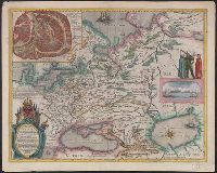
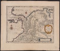
Bar scales given in "leucae Hispanicae" and "milliaria Germanica communia.", From Blaeu's Le theatre du monde ... Amsterdami : Apud Guiljelmum et Iohannem Blaeu, 1635., In French on verso, with caption title "De la terre ferme, & du nouveau Royaume de Granade & de Popayan" and signature 7D., and Shows southern part Central America and northwestern part of South America.
Publisher:
Guiljelmus Blaeuw excudit,
Subject (Geographic):
Colombia--Maps--Early works to 1800, Panama--Maps--Early works to 1800, and Venezuela--Maps--Early works to 1800
Subject (Name):
Blaeu, Joan, 1596-1673. Theatrum orbis terrarum. French and Blaeu, Willem Janszoon, 1571-1638. Theatrum orbis terrarum. French
Bar scales given in "leucae Hispanicae" and "milliaria Germanica communia.", From Blaeu's Le theatre du monde ... Amsterdami : Apud Guiljelmum et Iohannem Blaeu, 1635., In French on, and Shows southern part Central America and northwestern part of South America.
Publisher:
Guiljelmus Blaeuw excudit,
Subject (Geographic):
Colombia--Maps--Early works to 1800, Panama--Maps--Early works to 1800, and Venezuela--Maps--Early works to 1800
Subject (Name):
Blaeu, Joan, 1596-1673. Theatrum orbis terrarum. French and Blaeu, Willem Janszoon, 1571-1638. Theatrum orbis terrarum. French
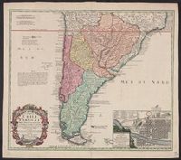
A note on the margin of the map in Latin text gives some historical data and comments upon the climate as being very cold and that the name (Chili) is therefore significan, In Latin and French., Inset: Plan de la ville de Santiago., and Relief shown pictorially.
Publisher:
Editoribus Homannianis Heredibus,
Subject (Geographic):
Santiago (Chile)--Maps--Early works to 1800 and South America--Maps--Early works to 1800
Subject (Name):
Homann Erben (Firm). Atlas geographicus maior and Techo, Nicolás del, 1611-1685