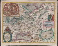
Dedicated to Czar Michaeli Foedrowits "ab Hesselo Gerardo, M.DC.XIII.", From : "Le theatre dv monde ou novvel atlas." By Iohannem and Guiljelmi F. Blaeu., Inset ma, Latin, with French text on verso: "Moscovie, ov la Rvssie blanche.", and Relief shown pictorially.
Publisher:
[Apud Iohannem] et Guiljelmum Blaeu,
Subject (Geographic):
Moscow (Russia)--Maps--Early works to 1800 and Russia--Maps--Early works to 1800
Subject (Name):
Blaeu, Willem Janszoon, 1571-1638. Theatrum orbis terrarum. French and Gerritsz., Hessel, 1581?-1632
Descriptio ac delineatio geographica detectionis freti, sive, transitus ad occasum supra terras
Image Count:
1
Abstract:
Map depicts the Coat of Arms of the United Kingdom (era of the Union of the Crowns), reigning between the years 1603-1707.
Alternative Title:
Tabula nautica, qua repraesentantur orae maritimae, meatus, ac freta, noviter a H. Hudsono Anglo ad Caurum supra Novam Franciam
Description:
Bound in after p. [2]., In pencil on recto: 170., Map cut and folded irregularly., Map has multiple small stains on both the recto and verso., and Scale [ca. 1:9,000,000].
Descriptio ac delineatio geographica detectionis freti, sive, transitus ad occasum supra terras
Image Count:
1
Abstract:
Map depicts the Coat of Arms of the United Kingdom (era of the Union of the Crowns), reigning between the years 1603-1707.
Alternative Title:
Tabula nautica ...
Description:
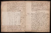
Bound in after p. [6]., In ink on recto: place names "Okkak", "Nain"[?] and one longer handwritten note on the bottom margin., Map cut and folded irregularly., Map has been repaired with multiple pieces of tape on verso., Map has multiple small stains on both the recto and verso., Printed on recto in lower right corner: A1., and Scale [ca. 1:9,000,000].
Subject (Geographic):
North Atlantic Ocean --Maps --Early works to 1800
Subject (Name):
Hudson, Henry, d. 1611
Collection Created:
Amsterodami Ex officina Hesse lij Gerardi. Anno 1613
Carte generale de la Tartarie chinoise et des royaumes de Corée et de Iapan
Description:
French alternate title only., Imperfect: western sheet (with cartouche) wanting. Sheet measures 54 x 54 cm, with watermark., Includes text and ill., and Relief shown pictorially.
Publisher:
Curis Homannianorum Heredum,
Subject (Geographic):
Chine--Divisions politiques et administratives--Cartes--Ouvrages avant 1800. and Manchuria (China)--Maps--Early works to 1800.
Subject (Name):
Anville, Jean Baptiste Bourguignon d', 1697-1782., Du Halde, J.-B. (Jean-Baptiste), 1674-1743., Gerbillon, Jean-François, 1654-1707., Homann Erben (Firm), and Mayer, Tobias, 1723-1762.