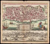
Lisabon die prächtigste Königl. Residenz Statt in Portugall u. florisanteste Handels Plaz am Austfluss des Tagi
Description:
"Cum gratia et privil. S.R.I. Vicariatus in partibus Rheni, Suevice, et Juris Franconici.", Historiated cartouche with note., Includes aerial view of "Lisabon" at bottom., and Manuscript number in upper right corner. From the Karpinski-von Wieser Map Collection.
Publisher:
[Matthaeus Seutter]
Subject (Geographic):
Lisbon (Portugal)--Aerial views--Early works to 1800, Lisbon (Portugal)--Maps--Early works to 1800, and Portugal--Lisbon
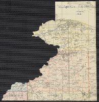
Sanborn fire insurance maps are a rich source of historic data on the urban built environment of North America during the 19th and early 20th centuries. The atlases were created for the purpose of underwriting fire insurance policies, which depended upon accurate and frequently-updated information about construction materials, municipal and transportation infrastructure, industrial and commercial landuse and more. The Yale University Library Map Department scanned its holdings of Sanborn fire insurance maps (consisting primarily of Connecticut towns) in order to make the maps more accessible.
Alternative Title:
April 1884, Litchfield, Conn.
Description:
"2 sheets.", Contains information on population, prevailing winds, water facilities and fire department., Partial cadastral map., and SMLMAPL 766 L71 1884: Sheets disbound. "Triplicate" stamp on both sheets. Library of Congress copyright stamp on title sheet.
Subject (Geographic):
Litchfield (Conn.)--Maps
Subject (Name):
Library of Congress Stamp
Subject (Topic):
Fire risk assessment--Connecticut--Litchfield--Maps and Real property--Connecticut--Litchfield--Maps
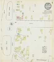
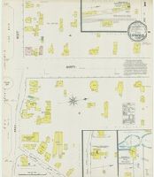
Sanborn fire insurance maps are a rich source of historic data on the urban built environment of North America during the 19th and early 20th centuries. The atlases were created for the purpose of underwriting fire insurance policies, which depended upon accurate and frequently-updated information about construction materials, municipal and transportation infrastructure, industrial and commercial landuse and more. The Yale University Library Map Department scanned its holdings of Sanborn fire insurance maps (consisting primarily of Connecticut towns) in order to make the maps more accessible.
Alternative Title:
Nov. 1889, Litchfield, Conn.
Description:
"2 sheets.", Contains information on population, prevailing winds, water facilities and fire department., Partial cadastral map., and SMLMAPL 766 L71 1889: Sheets disbound. "Triplicate" stamp on both sheets. Library of Congress copyright stamp on title sheet.
Subject (Geographic):
Litchfield (Conn.)--Maps
Subject (Name):
Library of Congress Stamp
Subject (Topic):
Fire risk assessment--Connecticut--Litchfield--Maps and Real property--Connecticut--Litchfield--Maps
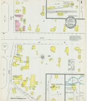
Sanborn fire insurance maps are a rich source of historic data on the urban built environment of North America during the 19th and early 20th centuries. The atlases were created for the purpose of underwriting fire insurance policies, which depended upon accurate and frequently-updated information about construction materials, municipal and transportation infrastructure, industrial and commercial landuse and more. The Yale University Library Map Department scanned its holdings of Sanborn fire insurance maps (consisting primarily of Connecticut towns) in order to make the maps more accessible.
Alternative Title:
Oct. 1895, Litchfield, Conn.
Description:
"(8287). 2 sheets.", Contains information on population, prevailing winds, water facilities and fire department., Partial cadastral map., and SMLMAPL 766 L71 1895: Sheets disbound. "Triplicate" stamp on both sheets. Library of Congress copyright stamp on title sheet.
Subject (Geographic):
Litchfield (Conn.)--Maps
Subject (Name):
Library of Congress Stamp
Subject (Topic):
Fire risk assessment--Connecticut--Litchfield--Maps and Real property--Connecticut--Litchfield--Maps
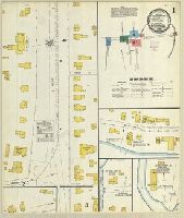
Sanborn fire insurance maps are a rich source of historic data on the urban built environment of North America during the 19th and early 20th centuries. The atlases were created for the purpose of underwriting fire insurance policies, which depended upon accurate and frequently-updated information about construction materials, municipal and transportation infrastructure, industrial and commercial landuse and more. The Yale University Library Map Department scanned its holdings of Sanborn fire insurance maps (consisting primarily of Connecticut towns) in order to make the maps more accessible.
Alternative Title:
Nov. 1901, Litchfield, Conn.
Description:
"3 sheets. 5114.", Contains information on population, prevailing winds, water facilities and fire department., Includes index of specials., Partial cadastral map., and SMLMAPL 766 L71 1901: Sheets disbound. "Triplicate" stamp on all sheets. Library of Congress copyright stamp on title sheet.
Subject (Geographic):
Litchfield (Conn.)--Maps
Subject (Name):
Library of Congress Stamp
Subject (Topic):
Fire risk assessment--Connecticut--Litchfield--Maps and Real property--Connecticut--Litchfield--Maps