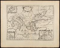
Appeared in various editions of Jan Jansson's Accuratissima orbis antiqui delineatio., Includes three insets: Europa; Minoium pelagus; Propontis [Sea of Marmora]., Manuscript number in upper left corner: 24., Relief shown pictorially., and Verso blank.
Publisher:
[Jan Jansson],
Subject (Geographic):
Mediterranean Region--Maps--Early works to 1800.
Subject (Name):
Jansson, Jan, 1588-1664. Accuratissima orbis antiqui delineatio.
Subject (Topic):
Argonauts (Greek mythology)--Travel--Maps--Early works to 1800. and Literary landmarks--Mediterranean Region--Maps--Early works to 1800.
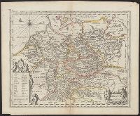
Appears in Jansson's historical atlas editions from 1652-1684., Hand colored., and Relief shown pictorially.
Publisher:
Apud Joannem Janssonium,
Subject (Geographic):
Benelux countries--Historical geography--Maps--Early works to 1800., Benelux countries--Maps--Early works to 1800., Europe, Central--Historical geography--Maps--Early works to 1800., Europe, Central--Maps--Early works to 1800., Europe, Eastern--Historical geography--Maps--Early works to 1800., Europe, Eastern--Maps--Early works to 1800., Germany--Historical geography--Maps--Early works to 1800., and Germany--Maps--Early works to 1800.
Subject (Name):
Jansson, Jan, 1588-1664
Subject (Topic):
Ethnology--Europe--Maps--Early works to 1800. and Germanic peoples--Maps--Early works to 1800.
Appeared in various editions of Jan Jansson's Accuratissima orbis antiqui delineatio., Coordinates not accurate as presented on map and are approximated., Relief shown pictorially., and Watermark. Manuscript number in upper left corner: 15.
Publisher:
[Jan Jansson],
Subject (Geographic):
Cisalpine Republic--Maps--Early works to 1800. and Lombardy (Italy)--Maps--Early works to 1800.
Subject (Name):
Jansson, Jan, 1588-1664. Accuratissima orbis antiqui delineatio. and Ortelius, Abraham, 1527-1598
Subject (Topic):
Historical geography--Italy--Lombardy--Maps--Early works to 1800.
Nova & accurata Tusciae antiquae descriptio, Nova et accurata Tusciae antiquae descriptio, and Nova et accurata Tvsciae antiqvae descriptio
Description:
Appeared in various editions of Jan Jansson's Accuratissima orbis antiqui delineatio., Borders are hand colored., Coordinates not accurate as presented on map and are approximated., Manuscript number in upper left corner: 16., Relief shown pictorially., and Verso blank.
Publisher:
[Jan Jansson],
Subject (Geographic):
Tuscany (Italy)--Maps--Early works to 1800.
Subject (Name):
Jansson, Jan, 1588-1664. Accuratissima orbis antiqui delineatio. and Ortelius, Abraham, 1527-1598
Subject (Topic):
Historical geography--Italy--Tuscany--Maps--Early works to 1800.
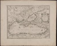
Appeared in various editions of Jan Jansson's Accuratissima orbis antiqui delineatio., Descriptive text in lower right cartouche beginning "Thraciae aliquot incogniti situs loca ...", Manuscript number in upper left corner: 22., Relief shown pictorially., Title in Greek and Latin; text in Latin., and Verso blank.
Publisher:
[Jan Jansson],
Subject (Geographic):
Bulgaria--Maps--Early works to 1800., Thrace--Maps--Early works to 1800., and Turkey--Maps--Early works to 1800.
Subject (Name):
Jansson, Jan, 1588-1664. Accuratissima orbis antiqui delineatio. and Ortelius, Abraham, 1527-1598
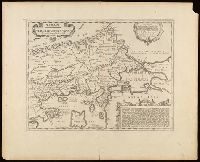
Appeared in various editions of Jan Jansson's Accuratissima orbis antiqui delineatio., Coordinates not accurate as given on map and are approximated., Manuscript number in upper left corner: 21., Relief shown pictorially., and Verso blank.
Publisher:
[Jan Jansson],
Subject (Geographic):
Bulgaria--Maps--Early works to 1800., Dacia--Maps--Early works to 1800., Moesia--Maps--Early works to 1800., and Romania--Maps--Early works to 1800.
Subject (Name):
Jansson, Jan, 1588-1664. Accuratissima orbis antiqui delineatio.