Map of all the world in two hemispheres in which are exactly described all the parts of the earth and seas
Description:
Dedicated To the most serene and most sacred majesty of Charles II ..., Described by Sanson ; corrected and amended by William Berry., Includes coat of arms and decorative cartouche containing dedication., No. 1 of 69 maps bound together in composite atlas., Prime meridian: Ferro., Relief shown pictorially., Scale [ca. 1:60 000 000]., and Shows California as an island.
Publisher:
Sold by William Berry at ye sign of the globe between Charing-Cross and White-Hall
Subject (Geographic):
Eastern Hemisphere --Maps --Early works to 1800 and Western Hemisphere --Maps --Early works to 1800
Map of the world showing routes of Cook's expeditions, with notes on ice, wild life etc. seen. Relief shown pictorially; imaginary coastline for eastern coast of Australian Bight., No. 1 of 43 maps bound together in composite atlas., and Scale [ca.1:68 000 000].
Publisher:
Published by Wm. Faden, Geographer to the King, Charing Cross
Subject (Name):
Cook, James, 1728-1779 and Mulgrave, Constantine John Phipps, Lord
Subject (Topic):
Discoveries in geography --Maps --To 1800 and World maps --Early works to 1800
Twenty four new and accurate maps of the several parts of Europe ... : all (except the last) new
Image Count:
1
Alternative Title:
The world in general
Description:
In pencil on verso: 1.
Subject (Name):
Barker, B. (Benjamin), d. 1764, bookseller, Clements, Henry, d. 1719, bookseller, King, Charles, d. 1735, bookseller, Nicholson, John, d. ca. 1717, bookseller, Parker, Richard, fl. 1692-1725, bookseller, and Tooke, Benjamin, d. 1716, bookseller
Subject (Topic):
Atlases --Early works to 1800 and World maps --Early works to 1800
Collection Created:
[London] : Sold by J. Nicholson at the King’s-Arms in Little Britain, Benj. Barker and Charles King ..., Benj. Tooke ..., Hen. Clements ..., R. Parker and Ralph Smith under the Royal-Exchange ..., [1715?]
Eastern old world hemisphere has imprint: London ... Dec. 1st, 1786 by William Faden., No. 2 of 43 maps bound together in composite atlas., Scale [1:60,000,000]., and Shows western and eastern hemispheres separately.
Ed. statement appears on Northern Hemisphere map only., No. 3 of 43 maps bound together in composite atlas., Relief shown pictorially., Scale [ca. 1:41,000,000. At equator]., and Shows tracks of various ocean voyages.
Publisher:
William Faden
Subject (Geographic):
Northern Hemisphere --Maps --Early works to 1800 and Southern Hemisphere --Maps --Early works to 1800
Hase, Johann Matthias, 1684-1742 Homann Erben (Firm) Lowitz, G. M. (George Moritz), 1722-1774
Published / Created:
1746
Call Number:
1975 Folio 31
Collection Title:
[Atlas factice of 42 maps, produced by the Homann Erben firm]
Image Count:
1
Alternative Title:
Mappe-monde qui represente les deux hemispheres savoir celui de l’orient et celui de l’occident, tiree des quatre cartes generales de feu M. le profess. Hasius, dressee par Mr. G.M. Lowitz et publiee par les Heritiers de Homann, avec privil. imper and Planiglobii terrestris mappa vniversalis
Publisher:
Homann Erben
Subject (Topic):
Atlases, German --Early works to 1800, Religion --Maps --Early works to 1800, and World maps --Early works to 1800
Hase, Johann Matthias, 1684-1742 Homann Erben (Firm) Lowitz, G. M. (George Moritz), 1722-1774
Published / Created:
1746
Call Number:
1973 Folio 30
Collection Title:
[Atlas factice of 32 maps and 1 distance table, produced by the Homann Erben firm]
Image Count:
1
Alternative Title:
Mappe-monde qui represente les deux hemispheres savoir celui de l’orient et celui de l’occident, tiree des quatre cartes generales de feu M. le profess. Hasius, dressee par Mr. G.M. Lowitz et publiee par les Heritiers de Homann and Planiglobii terrestris mappa vniversalis
Description:
Map colored to show distribution of religions.
Publisher:
[Homann Erben]
Subject (Topic):
Atlases, German --Early works to 1800, Religion --Maps --Early works to 1800, and World maps --Early works to 1800
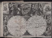
Journal ou relation exacte du voyage de Guill Schouten
Image Count:
1
Description:
Bound in after p. [8]., Busts of various explorers depicted around edges of map., Four small areas with stains on verso., Scale not given., and Western hemisphere of North and South America hand colored.
Subject (Topic):
Oceania --Discovery and exploration --Early works to 1800, Voyages around the world --Early works to 1800, and World maps --Early works to 1800
Collection Created:
A Paris : chez M. Gobert, au Palais en la gallerie des prisonniers, et les cartes, chez M. Tauernier, graueur du roy, demeurant au pont Marchand, 1618