Bottom center: "Apud Johan. et Cornelium Blaeu.", From: Blaeu, Joan. Theatrum orbis terrarum, sive atlas novus, Latin edition [Amsterdam : Joan Blaeu, 1644]., Lati, Relief shown pictorially., and Verso: Title "Moscoviae pars avstralior"; page no. 22; signature V.
Publisher:
Joan Blaeu,
Subject (Geographic):
Russia--Maps--Early works to 1800
Subject (Name):
Blaeu, Cornelis and Blaeu, Joan, 1596-1673. Theatrum orbis terrarum
Teutschland mit seinen angrantzenden Konigreichen und Provincien
Description:
"Mit privilegie derer H.H. Staten General des Vereinigten Niederländ"., Bar scales given in "teutsche Meilen" and "französiche Meilen"., Prime meridian: Ferro., Sheet measures 51.8 x 62.0 cm. Ms. no. in upper right corner: 105., and Watermark.
Publisher:
Nicolaus Visscher,
Subject (Geographic):
Europe, Central--Maps--Early works to 1800 and Holy Roman Empire--Maps--Early works to 1800
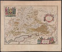
"C. privi.", Appeared in Peter Schenk's Atlas contractus [ca. 1700]., Backed with paper. Ms. no. "38" in upper-right corner. Sheet measures 53.7 x 62.4 cm. No. 37 of 87 maps bound together., Bar scales given in "milliaria Germanica," "milliaria Francica," and "milliaria geometrica sive Italica"., Prime meridian: Ferro., Relief shown pictorially., and Watermark.
Publisher:
Peter Schenk],
Subject (Geographic):
Benelux countries--Maps--Early works to 1800.
Subject (Name):
Schenk, Peter, 1660-1718 or 1719. Atlas contractus.
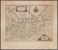
Backed with paper. Ms. no. "67" in upper-right corner. Sheet measures 53.7 x 62.3 cm. No. 62 of 87 maps bound together., Bar scales given in "milliaria Italica" and "milliaria Germanica.", and Prime meridian: Ferro.
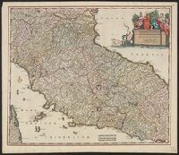
Appears in various editions of Wit's Atlas., Bar scales in "Milliaria Germanica communia 15 in uno gradu," "Milliaria Gallica magna, sive horae itineris,, Relief shown pictorially., and Sheet measures 53.3 x 62.1 cm. Ms. no. in upper right corner: 113.
Publisher:
Frederik de Wit?,
Subject (Geographic):
Tuscany (Grand Duchy)--Maps--Early works to 1800
Subject (Name):
Rodriguez, José M.--Bookplate and Wit, Frederik de. Atlas
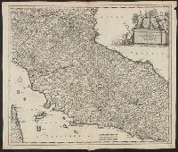
Appears in various editions of Wit's Atlas., Bar scales in "Milliaria Germanica communia 15 in uno gradu," "Milliaria Gallica magna, sive horae itineris," and "mil, Relief shown pictorially., and Sheet measures 53.3 x 62.1 cm. Ms. no. in upper right corner: 113.
Publisher:
Frederik de Wit?,
Subject (Geographic):
Tuscany (Grand Duchy)--Maps--Early works to 1800
Subject (Name):
Rodriguez, José M.--Bookplate and Wit, Frederik de. Atlas
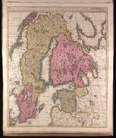
Appeard in Gerard Valck and Peter Schenk's Atlantis sylloge, ca. 1702., Backed with paper. Ms. no. "5" in upper left-hand corner. Sheet measures 62.8 x 53.4 cm. No. 4 of 87 maps bound together., Bar scales given in "milliaria Germanica" and "milliaria Suecia sive Danica"., Prime meridian: Ferro., and Relief shown pictorially.
Publisher:
Gerard Valck,
Subject (Geographic):
Baltic States--Maps--Early works to 1800. and Scandinavia--Maps--Early works to 1800.
Subject (Name):
Schenk, Peter, 1660-1718 or 1719. Atlantis sylloge compendiosa. and Valck, G. (Gerard), 1651 or 1652-1726.. Atlantis sylloge compendiosa.