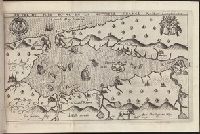
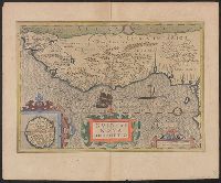
Bound in second after p. [48]., Depicts coat of arms of Henry IV of France and Mary I (Kingdom of Scotland)., Drawn by Marc Lescarbot, engraved by Jan Swelinck, published by I. Millot., Map has some small brown marks that can also be seen on the verso., Scale not given., and Teaching resource: Professor John Mack Faragher, History 141: The American West.
Subject (Geographic):
America --Discovery and exploration --French --Early works to 1800, New France --Discovery and exploration --Early works to 1800, and New France --Maps --Early works to 1800
Subject (Name):
Millot, Jean, b. 1582, printer, Swelinck, Jan, engraver, and Villegaignon, Nicolas Durand de, 1510-1571?
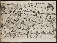
Bound in after p. 440., Depicts coat of arms of Henry IV of France and Mary I (Kingdom of Scotland)., Map has small brown mark on right-most edge that can also be seen on the verso., and Scale not given.
Subject (Geographic):
America --Discovery and exploration --French --Early works to 1800, New France --Discovery and exploration --Early works to 1800, and New France --Maps --Early works to 1800
Subject (Name):
Millot, Jean, b. 1582, printer, Swelinck, Jan, engraver
, and Villegaignon, Nicolas Durand de, 1510-1571?
Histoire de la Nouvelle-France : contenant les navigations, decouvertes, & habitations faites par
Image Count:
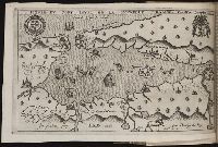
1
Description:
Bound in after p. 496., In pencil in upper left corner: 497., Map has three or four small brown marks on verso, the largest of which is on the right margin., and Scale not given.
Subject (Geographic):
America --Discovery and exploration --French --Early works to 1800, New France --Discovery and exploration --Early works to 1800, and New France --Maps --Early works to 1800
Subject (Name):
Millot, Jean, b. 1582, printer, Swelinck, Jan, engraver, and Villegaignon, Nicolas Durand de, 1510-1571?
Bar scales in "Miliaria Germanica communia" and "Miliaria Gallica communia.", From Blaeu's Le theatre du monde ... Amsterdami : Apud Guiljelmum et Iohannem Blaeu, 1635., In French on verso, with caption title "Le Destroict de Magellanes, & celuy de la Maire" and signature 7L., and Relief shown pictorially.
Publisher:
Guiljelmus Blaeuw excudit,
Subject (Geographic):
Magellan, Strait of (Chile and Argentina)--Maps--Early works to 1800
Subject (Name):
Blaeu, Joan, 1596-1673. Theatrum orbis terrarum. French, Blaeu, Willem Janszoon, 1571-1638. Theatrum orbis terrarum. French, and Gryp, Dirck, engraver
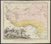
From the author's Gerardi Mercatoris atlas. 1628., Inset: I. S. Thomae., Map text in Latin. Text on verso in French., Relief shown pictorially., and Text on verso titled "Guinee, avec les isles de S. Thomas, du Prince, et d'Anobon," p. 637 and 640.
Publisher:
Sumptibus & typis aeneis Henrici Hondij,
Subject (Geographic):
Africa, West--Maps--Early works to 1800
Subject (Name):
Hondius, Hendrik, 1597-1651 and Mercator, Gerhard, 1512-1594. Gerardi Mercatoris Atlas
Guinea propria, nec non Nigritiæ vel Terræ Nigrovrm maxima pars, Guinee de meme que la plus grande partie du Pais des Negres, and Gvinee de meme que la plus grande partie du Pais des Negres
Description:
Covers West Africa from Gabon in the south to Niger, Mali, and Mauritania in the north., Has watermark., Includes indexed ill. depicting the dress, dwellings, and work of native Africans., Prime meridian: Ferro., and Relief shown pictorially.
Publisher:
Homannianorum Heredum,
Subject (Geographic):
Africa, West--Maps--Early works to 1800
Subject (Name):
Anville, Jean Baptiste Bourguignon d', 1697-1782 and Marchais, R. de
Dorn, Sebastian Hase, Johann Matthias, 1684-1742 Homann Erben (Firm)
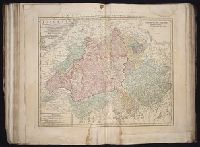
Published / Created:
1744
Call Number:
1983 Folio 23
Collection Title:
[Atlas factice of 50 maps, primarily by Johann Baptist Homann and/or issued by the Homann Erben
Image Count:
1
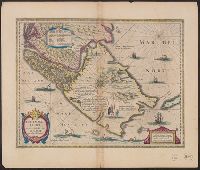
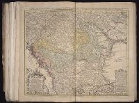
Alternative Title:
Carte d’Hongrie en general, contenant selon la division ancienne & methodique, la Hongrie, en particulier, la Croatie, la Dalmatie, la Bosnie, la Servie, la Boulgarie, la Principaute de Transylvanie, les Despotats de Walachie & de Moldav and Hungariae ampliori significatu et veteris vel methodicae, complexae regna: Hungariae Propriae, Crotiae, Dalmatiae, Bosniae, Serviae, Cumaniae, principatum: Transylvaniae, despotus: Walachiae, Moldaviae (exclusis ab eadem alienatis Galitia et Ludmomiria) in suas provincias ac partes divisae et quoad Imperantes ex Austriacis, Turcis et Venetis distinctae (juncta tamen propter commidatem Romania vel Romelia Turcica) tabula
Publisher:
Curantibus Homannianis Heredibus
Subject (Geographic):
Balkan Peninsula --Maps --Early works to 1800 and Hungary --Maps --Early works to 1800