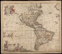
"Cum Privilegio D.D. Ordinum Holl. Westfriliegs.", According to P.D. Burden, Mapping of North America, this is the seventh state of de Wit's map of America, with a new title engraved adding the privilege statement, lower case letters inserted between the latitude numbers and upper case letters between the longitude, and the longitudinal line 338° bearing a bad plate crack in the souther hemipshere, with an erased compass rose at the junction of 338° longitude and 10° north latitude., Appears in various editions of Wit's Atlas., Baked with paper., Number "2" in upper right corner., Prime meridian: Ferro., Relief shown pictorially., and Watermark.
Subject (Geographic):
America--Maps--Early works to 1800. and Western Hemisphere--Maps--Early works to 1800.
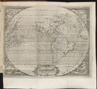
De orbe novo Petri Martyris Anglerii Mediolanensis, protonotarij, & Caroli quinti Senatoris decades
Image Count:
1
Description:
Copy of map published in Hakluyt's Voyages in 1587., Preceding p. 1., and Teaching resource: Professor John Mack Faragher, History 141: The American West.
Subject (Geographic):
America --Discovery and exploration, Latin America --Description and travel, and West Indies --History
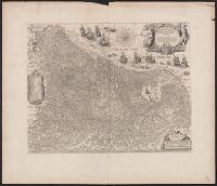
Coordinates not present on map and are approximated., From Joan Blaeu's Atlas maior (1662)., Latin text on verso; paginated ij-j, with caption Belgica., Relief shown pictorially., and With north oriented towards the upper right.
Subject (Geographic):
Netherlands--Maps--Early works to 1800
Subject (Name):
Blaeu, Joan, 1596-1673. Atlas maior, Ende, Josua van den, approximately 1584-approximately 1634, engraver, and Typographia Blaviani
Appeared in Willem and Joan Blaeu's Theatrum orbis terrarum., Backed with linen., Coordinates not present on map and are approximated., Relief shown pictorially., and With north oriented towards the upper right.
Subject (Geographic):
Netherlands--Maps--Early works to 1800
Subject (Name):
Blaeu, Joan, 1596-1673. Theatrum orbis terrarum, Blaeu, Willem Janszoon, 1571-1638. Theatrum orbis terrarum, and Ende, Josua van den, approximately 1584-approximately 1634, engraver
Mecometrie de leymant, cest a dire La maniere de mesvrer les longitudes par le moyen de l’eymant
Image Count:
1
Description:
Bound in preceding t.p. for pt. [2] (Premier livre de la Mecometrie arithmetique de l’eymant)., Imperfect: map rubbed, with some loss of map and text., Map has small tear on left edge at gutter., and Scale [ca. 1:100,000,000].
Subject (Topic):
Longitude --Early works to 1800 and World maps --Early works to 1800
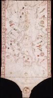
"Donnus Dominicus Vigliarolus Calaber de civitate Stili me fecit in urbe felicis Panormi 1577.", Color: red, green, and gold., Includes degrees of latitude along left edge: 60°N to 24°N., Includes six full compass roses, four half compass roses, and eight cherubs., Left portion of chart with illustration of the Pietá., and Title devised by cataloger.
Subject (Geographic):
Black Sea--Maps--Early works to 1800. and Mediterranean Sea--Maps--Early works to 1800.
Subject (Topic):
Nautical charts--Black Sea--Early works to 1800. and Nautical charts--Mediterranean Sea--Early works to 1800.
Jenkinson, Anthony, 1529-1611 Ortelius, Abraham, 1527-1598. Theatrum orbis terrarum Plantin, Christophe, approximately 1520-1589, printer
Call Number:
35 1562
Container / Volume:
BRBL_00099
Image Count:
1
Resource Type:
Maps, Atlases & Globes
Alternative Title:
Russiae, Moscoviae et Tartariae descriptio
Description:
"Cum priuilegio.", From Abraham Ortelius's Theatrum orbis terrarum (Antwerp, 1584)., Imperfect: slightly chipped along fold in center, with slight loss of text. Backed with paper., In Latin on verso., and Relief shown pictorially.