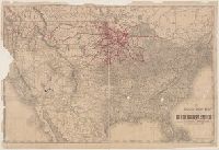
Across top of map: "Panoramic view of the country between San Francisco and St. Louis.", Includes ill., text, population information, and inset of "Central America.", Prime meridians: Washington and Greenwich., and Relief shown by hachures.
Louisiana State Board of Agriculture and Immigration
Published / Created:
c1910.
Call Number:
795 1910
Container / Volume:
BRBL_00521
Image Count:
2
Resource Type:
Maps, Atlases & Globes
Description:
Includes table of navigable waters and inset of "Vicinity of New Orleans." and Text of "An agricultural and physiological description of Louisiana" on verso.
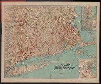
In left margin: Directory of Principal Cities. In lower right corner [Directory of] South Carolina Railroads. and On verso: Directory of Counties, Creeks, Islands, Rivers and Towns.
Includes list of Alabama Railroads, and index., ms. notations in red, green and pencil. Imperfect: pamphlet wanting., and Title of accompanying pamphlet: The Rand-McNally indexed county and township pocket map and shippers' guide of Illinois: showing railroads,