Skip to search
Skip to main content
Skip to first result
Search
You Searched For
Language
Latin
New Search
Search Results
Creator:
Published / Created:
[ca. 1760]
Call Number:
60 1760B
Container / Volume:
BRBL_00323
Image Count:
1
Resource Type:
Maps, Atlases & Globes
Description:
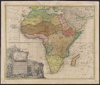
Has watermark., Includes "Admonitio" and 4 bar scales., Prime meridian: Ferro., Relief shown pictorially., Sheet measures 55.7 x 67.2 cm., and Shows east coast of Brazil.
Publisher:
Prostat apud Tobiam Conr. Lotter calcogr.,
Subject (Geographic):
Africa--Maps--Early works to 1800
Subject (Name):
Lotter, Tobias Conrad, 1717-1777
Found in:
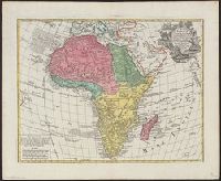
Beinecke Rare Book and Manuscript Library > Africa : concinnata secundum observationes membror. acad. regal. scientiarum et non nullorum aliorum, et juxta recentissimas annotationes / per G. de l'Isle, geographum.
Creator:
Published / Created:
after 1741]
Call Number:
60 1735
Container / Volume:
BRBL_00323
Image Count:
1
Resource Type:
Maps, Atlases & Globes
Description:
"Cum gratia et privil. S.R.I. Vicari atg., in partibg. Rheni, Suevice, et juris Franconici.", Has watermark., Includes ornamental cartouche and text., and Relief shown pictorially.
Publisher:
M. Seutter,
Subject (Geographic):
Africa--Maps--Early works to 1800.
Found in:
Beinecke Rare Book and Manuscript Library > Africa iuxta navigationes et observationaes recentissimas aucta, correcta et in sua regna et status divisa / in lucem edita a Matth. Seuttero, s. Caes. maj. geographo aug.
Creator:
Published / Created:
1720?]
Call Number:
69 1720
Container / Volume:
BRBL_00352
Image Count:
1
Resource Type:
Maps, Atlases & Globes
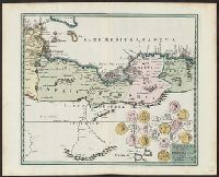
Description:
Covers northern Libya and eastern Tunisia., Includes ill. of coins., Relief shown pictorially., and Shows historical place names and boundaries.
Publisher:
C. Weigel,
Subject (Geographic):
Libya--Historical geography--Maps--Early works to 1800 and Tunisia--Historical geography--Maps--Early works to 1800
Found in:
Beinecke Rare Book and Manuscript Library > Africa propria et Cyrenaica / studio Chri. Weigelii Norimbergae, cum privil[egio], S[acra] C[aesareae] M[ajestatis].
Creator:
Published / Created:
[1737?]
Call Number:
60 1737B
Container / Volume:
BRBL_00323
Image Count:
1
Resource Type:
Maps, Atlases & Globes
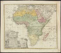
Description:
Illus. cartouche. and Relief shown pictorially.
Publisher:
Impensis Homannianorum Heredum,
Subject (Geographic):
Africa--Maps--Early works to 1800
Found in:
Beinecke Rare Book and Manuscript Library > Africa secundum legitimas projectionis stereographicae regulas : et juxta recentissimas relationes et observationes in subsidium vocatis quoque veterum Leonis Africani ... / à Joh. Matthia Hasio, M.P.P.O. ...
Creator:
Published / Created:
[ca. 1737]
Call Number:
60 1737A
Container / Volume:
BRBL_00323
Image Count:
1
Resource Type:
Maps, Atlases & Globes
Description:
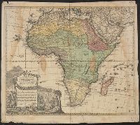
Cartouche lacks privilege., Includes text and ornamental cartouche with Africans, Europeans, flora, fauna, etc., Relief shown pictorially., and Sheet measures 52 x 60 cm. Ms. no. on recto: 58 [?].
Publisher:
In officina Homanniana,
Subject (Geographic):
Africa--Maps--Early works to 1800
Subject (Name):
Homann Erben (Firm)
Found in:
Beinecke Rare Book and Manuscript Library > Africa secundum legitimas projectionis stereographicae regulas et juxta recentissimas relationes et observationes in subsidium vocatis quoque veterum Leonis Africani Nubiensis Geographi et aliorum monumentis et eleminatis fabulosis aliorum designationibus
Creator:
Published / Created:
1737
Call Number:
60 1737
Container / Volume:
BRBL_00323
Image Count:
1
Resource Type:
Maps, Atlases & Globes
Description:
"Cum privil. S.C.M. nec non S.R.M. Polon. et Elect. Sax. A. 1737.", Includes text and ornamental cartouche with Africans, Europeans, flora, fauna, etc., Relief shown pictorially., and Sheet measures 52 x 62 cm.
Publisher:
In officina Homanniana,
Subject (Geographic):
Africa--Maps--Early works to 1800
Subject (Name):
Homann Erben (Firm)
Found in:
Beinecke Rare Book and Manuscript Library > Africa secundum legitimas projectionis stereographicae regulas et juxta recentissimas relationes et observationes in subsidium vocatis quoque veterum Leonis Africani Nubiensis Geographi et aliorum monumentis et eleminatis fabulosis aliorum designationibus
Creator:
Published / Created:
[ca. 1737]
Call Number:
1983 Folio 23
Collection Title:
[Atlas factice of 50 maps, primarily by Johann Baptist Homann and/or issued by the Homann Erben
Image Count:
1
Publisher:
Impensis Homanniorum Heredum
Subject (Geographic):
Africa --Maps --Early works to 1800
Collection Created:
[Nuremberg : Homann Erben, 1710-1786]
Found in:
Beinecke Rare Book and Manuscript Library > Africa secundum legitimas projectionis stereographicae regulas et juxta recentissimas relationes et observationes in subsidium vocatis quoque veterum Leonis Africani Nubiensis Geographi et aliorum monumentis et eleminatis fabulosis aliorum designationibus
Creator:
Published / Created:
1737
Call Number:
1975 Folio 31
Collection Title:
[Atlas factice of 42 maps, produced by the Homann Erben firm]
Image Count:
1
Publisher:
Impensis Homanniorum Heredum
Subject (Geographic):
Africa --Maps --Early works to 1800
Subject (Topic):
Atlases, German --Early works to 1800
Collection Created:
[Nuremberg,
Found in:
Beinecke Rare Book and Manuscript Library > Africa secundum legitimas projectionis stereographicae regulas et juxta recentissimas relationes et observationes in subsidium vocatis quoque veterum Leonis Africani Nubiensis Geographi et aliorum monumentis et eleminatis fabulosis aliorum designationibus
Creator:
Published / Created:
1737
Call Number:
1973 Folio 30
Collection Title:
[Atlas factice of 32 maps and 1 distance table, produced by the Homann Erben firm]
Image Count:
2
Publisher:
Impensis Homanniorum Heredum
Subject (Geographic):
Africa --Maps --Early works to 1800
Subject (Topic):
Atlases, German --Early works to 1800
Collection Created:
[Nuremberg : s.n., 1701-1760]
Found in:
Beinecke Rare Book and Manuscript Library > Africa secundum legitimas projectionis stereographicae regulas et juxta recentissimas relationes et observationes in subsidium vocatis quoque veterum Leonis Africani Nubiensis Geographi et aliorum monumentis et eleminatis fabulosis aliorum designationibus
Creator:
Published / Created:
1592]
Call Number:
60 1592
Container / Volume:
BRBL_00321
Image Count:
2
Resource Type:
Maps, Atlases & Globes
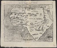
Description:
Appears in Bünting's Itinerarium Sacrae Scripturae., In top margin: 20 -- 21., Includes ill., Latin, German., Relief shown pictorially., Sheet measures 32 x 39 cm., and Text on verso.
Publisher:
Heinrich Bünting,
Subject (Geographic):
Africa--Maps--Early works to 1800
Subject (Name):
Bünting, Heinrich, 1545-1606. Itinerarium Sacrae Scripturae
Found in:
Beinecke Rare Book and Manuscript Library > Africa tertia pars terrae.
Branch:v1.61.8 ,Deployed:2024-06-20T11:15:02-04:00