Pickaert, Pieter, 1668 or 9-ca. 1732 Scherm, Laurens Schoonebeek, Adriaan, 1657 or 8-1705
Published / Created:
[1692?]
Call Number:
2008 +141
Image Count:
65
Abstract:
A series of sixty plates published in Amsterdam and with captions in Dutch and French, this work illustrates the Glorious Revolution in England, from the flight of James II through the coronation of William and Mary.
Alternative Title:
Engelands schouwtoneel and Theatre d’Angleterre
Publisher:
by Adr. Schoonebeek in de Kalverstraat
Subject (Geographic):
Great Britain --History --James II, 1685-1688 --Pictorial works, Great Britain --History --Revolution of 1688 --Pictorial works, and Great Britain --History --William and Mary, 1689-1702 --Pictorial works
Bat. cum Privil. Ordin. Gener, Belgii Faederati--Title cartouche., Features include ornate title cartouche (top left) with cherubs, male and female figures and royal coat-of-arms supported by lion and unicorn, arms of Scotland supported by cherubs (above scale cartouche at top right), compass indicator and coasts shaded outwards., In Latin with some place names in English; explanations and title for index to places in Dutch and English., No. 7 of 69 maps bound together in composite atlas., Relief shown pictorially., Scale [ca. 1:960 000]., Scale statement reads: Milliaria Germanica Communia 15 in uno Gradu, with scale bar graded [0]-10; Milliaria Scotica Communia quorum 50 in uno Gradu, with scale bar graded [0]-34; Milliaria Gallica quae et Horae Itineris 20 in uno Gradu, with scale bar graded [0]-14., Shows grid, rivers and tributaries, lochs (shaded), trees, place and county names, settlements (symbols classified by importance in legend), territorial boundaries., Shows Scotland including the Hebrides and Orkney Islands., and The four cardinal points are written in the borders.
Gouwen, Gilliam van der Visscher, Nicolaes, 1649-1702, creator
Published / Created:
[1690?]
Call Number:
1973 Folio 10
Image Count:
1
Resource Type:
Maps, Atlases & Globes
Alternative Title:
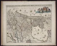
Landkaart vertonende het Graafschap Holland
Description:
Alternate title in upper margin: Landkaart vertonende het Graafschap Holland, seer dienstig om te reysen na : en van syne naburige provincien, als mede de Hoven van Soestdyk, 't Loo en Cleef / t' Amsteldam door Nicolaus Visscher met privilegie., Bar scales in Milliaria Germanica communia and Milliaria Gallica sive horae itineris., Ferro meridian., Includes col. ill. of figures in title cartouche., No. 44 of 69 maps bound together in composite atlas., Place-names in Dutch., Relief shown pictorially., and Scale [ca. 1:300 000].
Uytenbogaart, J. W. H. (Johannes Wilhelmus Huybert) Wit, Frederik de., creator
Published / Created:
[1680?]
Call Number:
1973 Folio 10
Image Count:
1
Resource Type:
Maps, Atlases & Globes
Description:
Appears in the Wit's Atlas from 1680., Dedication: Amplissimo Doctissimoque Viro Domino Do. Joanni Uytenbogaert Jcto. nomine Illustrium et praepotent. DD. ordinum Hollandiae et Westvrisiae Aerary Publici Amstelodamensis Tribuno., Includes color illustrated views of Messina, Catania, and Trapano, and ancillary maps of Milazzo and Palermo., No. 21 of 69 maps bound together in composite atlas., Oriented with north toward the upper left., Relief shown pictorially., Scale indeterminable., and Urbibus praecipuis exornatum et novissime editum per F. de Wit.
Publisher:
Gedruckt tot Amsterdam by Frederik de Wit inde Kalverstraet by den Dam inde Witte Paskaert
Ferro meridian., Gemeene Duytsche mylen van 15 in een graedt., No. 53 of 69 maps bound together in composite atlas., Relief shown pictorially., and Scale [ca 1:8 750 000].
Publisher:
By Frederick de Wit in de Kalversbraet in de Witte Pascaert
Charts and title pages in English, text in Dutch., Map oriented with North at bottom left., and Volvelle on p. [17].
Publisher:
Jodocus Hondius excudit,
Subject (Geographic):
Europe --Maps --Early works to 1800, Great Britain --Maps --Early works to 1800, Netherlands --Maps --Early works to 1800, and North Sea --Maps --Early works to 1800