Skip to search
Skip to main content
Skip to first result
Search
You Searched For
Extent of Digitization
Completely digitized
Genre
Engravings
Language
Latin
New Search
Search Results
Creator:
Published / Created:
[ca. 1657?]
Call Number:
1973 Folio 10
Image Count:
1
Resource Type:
Maps, Atlases & Globes
Description:
Bar scales given in milliaria Germanica communia and milliaria Gallica communia., Ferro meridian., No. 54 of 69 maps bound together in composite atlas., Relief shown pictorially., and Scale [ca 1:1 330 000].
Publisher:
Sumptibus Ioannes Ianssonii
Subject (Geographic):
Syria --Maps --Early works to 1800
Found in:
Beinecke Rare Book and Manuscript Library > Syriae sive Soriae : nova et accurata descriptio
Creator:
Published / Created:
[ca. 1715]
Call Number:
1983 Folio 23
Collection Title:
[Atlas factice of 50 maps, primarily by Johann Baptist Homann and/or issued by the Homann Erben
Image Count:
1
Publisher:
[Johann Baptist Homann]
Subject (Geographic):
Carniola (Slovenia) --Maps --Early works to 1800, Croatia --Maps --Early works to 1800, and Ljubljana (Slovenia) --Maps, Pictorial --Early works to 1800
Collection Created:
[Nuremberg : Homann Erben, 1710-1786]
Found in:
Beinecke Rare Book and Manuscript Library > Tabula Ducatus Carnioliae, vindorum Marchiae et Histriae et mente Mustr. quondam J.B. Valvasorii / concinnatia et exhibita a Io. Bapt. Homanno, S.C.M. Geogr
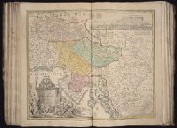
Creator:
Published / Created:
[1662]
Call Number:
1973 Folio 10
Image Count:
1
Resource Type:
Maps, Atlases & Globes
Description:
Ferro meridian., No. 52 of 69 maps bound together in composite atlas., Relief shown pictorially., and Scale [ca. 1:13 750 000].
Subject (Geographic):
South Asia --Maps --Early works to 1800 and Southeast Asia --Maps --Early works to 1800
Found in:
Beinecke Rare Book and Manuscript Library > Tabula Indiae orientalis
Creator:
Published / Created:
ca. 1684
Call Number:
Folio 469
Collection Title:
[Atlas factice of 13 maps by Nicolaes Visscher I, Nicolaes Visscher II, Guillaume Sanson, and
Image Count:
1
Publisher:
Nicolaes Visscher
Subject (Geographic):
Brabant (Belgium) --Maps --Early works to 1800 and Europe --Maps --Early works to 1800
Subject (Topic):
Atlases, Dutch --Early works to 1800
Found in:
Beinecke Rare Book and Manuscript Library > Tabula ducatus Brabantiae continens Marchionatum sacri imperii et dominium Mechliniense / [cartographic material] / de novo accurate emendata et in lucem edita per Nicolaum Visscher
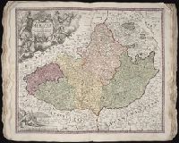
Creator:
Published / Created:
[169-?]
Call Number:
1973 Folio 10
Image Count:
1
Resource Type:
Maps, Atlases & Globes
Description:
Bar scales in Mill. Germanica Comm 15 in uno gradu and Mill. Gallica et Livonica quae horae itineris., Ferro meridian., No. 38 of 69 maps bound together in composite atlas., Relief shown pictorially., and Scale [ca. 1:910 000].
Subject (Geographic):
Estonia --Maps --Early works to 1800 and Latvia --Maps --Early works to 1800
Found in:
Beinecke Rare Book and Manuscript Library > Tabula ducatuum Livoniae et Curlandiae: recentior incisa editaque
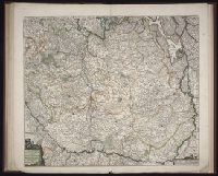
Creator:
Published / Created:
ca. 1715
Call Number:
1975 Folio 31
Collection Title:
[Atlas factice of 42 maps, produced by the Homann Erben firm]
Image Count:
1
Publisher:
Johann Baptist Homann
Subject (Geographic):
Moravia (Czech Republic) --Maps --Early works to 1800
Subject (Topic):
Atlases, German --Early works to 1800
Collection Created:
[Nuremberg,
Found in:
Beinecke Rare Book and Manuscript Library > Tabula generalis Marchionatus Moraviae in sex circulos divisae [cartographic material] : quos mandato Caesareo accurate emensus / hac mappa delineatos exhibet Ioh. Christoph. Mueller, S.C.M. Capitan ; editore Joh. Bapt. Homanno
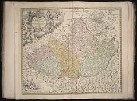
Creator:
Published / Created:
[ca. 1715]
Call Number:
1983 Folio 23
Collection Title:
[Atlas factice of 50 maps, primarily by Johann Baptist Homann and/or issued by the Homann Erben
Image Count:
1
Publisher:
[Johann Baptist Homann]
Subject (Geographic):
Moravia (Czech Republic) --Maps --Early works to 1800
Collection Created:
[Nuremberg : Homann Erben, 1710-1786]
Found in:
Beinecke Rare Book and Manuscript Library > Tabula generalis Marchionatus Moraviae in sex circulos divisae [cartographic material] : quos mandato Caesareo accurate emensus / hac mappa delineatos exhibet Ioh. Christoph. Muå¬ller, S.C.M. Capitan ; editore Joh. Bapt. Homanno
Creator:
Published / Created:
1775
Call Number:
1983 Folio 23
Collection Title:
[Atlas factice of 50 maps, primarily by Johann Baptist Homann and/or issued by the Homann Erben
Image Count:
1
Publisher:
Impensis Homannianorum Haeredum
Subject (Geographic):
Prussia, east (Poland and Russia) --Maps --Early works to 1800
Collection Created:
[Nuremberg : Homann Erben, 1710-1786]
Found in:
Beinecke Rare Book and Manuscript Library > Tabula regni Borussiae, Borussiam orientalem exhibens [cartographic material] / F.L. Guessefeld, C. P. S. C. M
Creator:
Published / Created:
ca. 1715
Call Number:
1975 Folio 31
Collection Title:
[Atlas factice of 42 maps, produced by the Homann Erben firm]
Image Count:
1
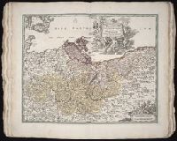
Alternative Title:
Tabula marchionatus Brandenburgici et ducatus Pomeraniae
Publisher:
Johann Baptist Homann
Subject (Geographic):
Brandenburg (Germany) --Maps --Early works to 1800 and Pomerania (Poland and Germany) --Maps --Early works to 1800
Subject (Topic):
Atlases, German --Early works to 1800
Collection Created:
[Nuremberg,
Found in:
Beinecke Rare Book and Manuscript Library > Tabvla marchionatvs Brandenbvrgici et dvcatvs Pomeraniae [cartographic material] : quae sunt pars septentrionalis circuli Saxoniae superioris / novissime edita a Ioh. Baptista Homanno
Creator:
Published / Created:
ann. 1605.
Call Number:
1976 Folio 46
Image Count:
125
Resource Type:
Books, Journals & Pamphlets
Alternative Title:
Mariners mirrour.
Description:
Charts and title pages in English, text in Dutch., Map oriented with North at bottom left., and Volvelle on p. [17].
Publisher:
Jodocus Hondius excudit,
Subject (Geographic):
Europe --Maps --Early works to 1800, Great Britain --Maps --Early works to 1800, Netherlands --Maps --Early works to 1800, and North Sea --Maps --Early works to 1800
Found in:
Beinecke Rare Book and Manuscript Library > The mariners mirrovr wherin may playnly be seen the courses, heights, distances, depths, sounding, flouds and ebs, risings of lands, rocks ... of the harbouroughs, havens and ports of the greatest part of Europe: ... together w.th the rules and instrumeíÄ
Branch:v1.61.8 ,Deployed:2024-06-20T11:14:46-04:00