Skip to search
Skip to main content
Skip to first result
Search
You Searched For
Repository
Beinecke Rare Book and Manuscript Library
Format
cartographic
Genre
Maps
New Search
Search Results
Published / Created:
1841
Call Number:
32 L84 1841
Container / Volume:
BRBL_00050
Image Count:
1
Resource Type:
Maps, Atlases & Globes
Publisher:
Cruchley,
Subject (Geographic):
London (England)--Maps
Found in:
Beinecke Rare Book and Manuscript Library > 24 miles round London.
Creator:
Published / Created:
1867, c1866.
Call Number:
771 N49 1867A
Container / Volume:
BRBL_00487
Image Count:
2
Resource Type:
Maps, Atlases & Globes
Alternative Title:
Forty miles around New York., H.H. Lloyd's new map of the great metropolis., H.H. Lloyd's New-York and forty miles around it., New map of the great metropolis., and New-York and forty miles around it.
Description:
Includes lists of maps published by the company (on map) and Relief shown by hachures.
Publisher:
H.H. Lloyd & Co.,
Subject (Geographic):
New York (N.Y.)--Maps and New York Region--Maps
Found in:
Beinecke Rare Book and Manuscript Library > 40 miles around New York ; H.H. Lloyd's new map of the great metropolis, : including the cities of New York, Brooklyn, Jersey City, Hoboken, &c.
Published / Created:
c1922.
Call Number:
846ag G75 1922
Container / Volume:
BRBL_00623
Image Count:
2
Resource Type:
Maps, Atlases & Globes
Alternative Title:
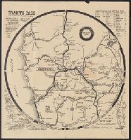
Grants Pass highway map, Grants Pass, Josephine County, Oregon, and Official highway map
Description:
Copyright: J.R. Harvey, Grants Pass, Oregon., Includes distance table, ancillary map of Pacific (6th) Highway area in Grants Pass, location map, and text., Relief shown by hachures and pictorially., and Text and photos on verso.
Publisher:
Grants Pass Chamber of Commerce?],
Subject (Geographic):
Grants Pass Region (Or.)--Maps
Subject (Name):
Grants Pass Chamber of Commerce and Harvey, J. R
Subject (Topic):
Roads--Oregon--Grants Pass Region--Maps
Found in:
Beinecke Rare Book and Manuscript Library > 80 mile radius, Grants Pass highway map / approved by Josephine County Court, Grants Pass Chamber of Commerce, Grants Pass City Council.
Creator:
Published / Created:
1941]
Call Number:
35 1941B
Container / Volume:
BRBL_00101
Image Count:
2
Resource Type:
Maps, Atlases & Globes
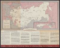
Alternative Title:
American Soviet diplomatic relations and Eighth anniversary American Soviet diplomatic relations
Description:
Panel title.
Publisher:
American Council on Soviet Relations,
Subject (Geographic):
Soviet Union--Foreign relations--1917-1945, Soviet Union--Foreign relations--United States, Soviet Union--Maps, United States--Foreign relations--1933-1945, and United States--Foreign relations--Soviet Union
Found in:
Beinecke Rare Book and Manuscript Library > 8th anniversary American Soviet diplomatic relations.
Published / Created:
1846
Call Number:
1976 Folio 93
Collection Title:
A new universal atlas containing maps of the various empires, kingdoms, states and republics of the
Image Count:
1
Resource Type:
Maps, Atlases & Globes
Publisher:
S. Augustus Mitchell
Subject (Geographic):
Connecticut
Collection Created:
Philadelphia, S.A. Mitchell, 1847, c1844
Found in:
Beinecke Rare Book and Manuscript Library > 9. Connecticut
Call Number:
8075cea 1848
Container / Volume:
BRBL_00551
Image Count:
1
Resource Type:
Maps, Atlases & Globes
Description:
Insets: Put in Bay, Mohawk ay, Long Point ay, Entrance Niagra River, Grand River, Miamis Bay.
Subject (Geographic):
Great Lakes--Maps
Found in:
Beinecke Rare Book and Manuscript Library > A Chart of Lake Erie ... Buffalo, A. Burke, 1848.
Published / Created:
1870]
Call Number:
8555cea K61 1780
Container / Volume:
BRBL_00642
Image Count:
1
Resource Type:
Maps, Atlases & Globes
Publisher:
s. n.,
Subject (Geographic):
Jamaica--Maps
Found in:
Beinecke Rare Book and Manuscript Library > A Chart of Port Royal and Kingston Harbours in the Island of Jamaica... / by Jos. Fred. W. des Barres.
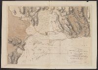
Published / Created:
1777
Call Number:
771 1777A
Container / Volume:
BRBL_00713
Image Count:
9
Resource Type:
Maps, Atlases & Globes
Description:
Included is ms. copy [1777] of the Grant of the Province of Laconia to Sir Ferdinando Gorges and Capt. John Mason dated 17th Nov., 1629.
Subject (Geographic):
New York--Maps, Manuscript--Early works to 1800
Found in:
Beinecke Rare Book and Manuscript Library > A Chart of the Ancient Province of Laconia, Granted to Sir Ferdinando Gorges and Captain John Mason in 1629, shewing the boundaries describ'd in the patent, with its vicinity to the neighbouring provinces in North America. By J. Carver.
Published / Created:
1782
Call Number:
21cea 1782
Container / Volume:
BRBL_00016
Image Count:
1
Resource Type:
Maps, Atlases & Globes
Description:
From North American Pilot 1783.
Publisher:
Robt. Sayer,
Subject (Geographic):
Atlantic Ocean--Maps--Early works to 1800
Found in:
Beinecke Rare Book and Manuscript Library > A Chart of the Atlantic Ocean.
Published / Created:
1746
Call Number:
307cea 1746
Container / Volume:
BRBL_00036
Image Count:
1
Resource Type:
Maps, Atlases & Globes
Description:
Preliminary record.
Publisher:
A. Miller,
Subject (Geographic):
Europe, Western--Maps--Early works to 1800
Found in:
Beinecke Rare Book and Manuscript Library > A Chart of the English Channel, the Bay of Biscay, with part of the Ocean and Mediterranean ... By T. Kitchin.
Branch:v1.61.6 ,Deployed:2024-06-12T09:55:37-04:00