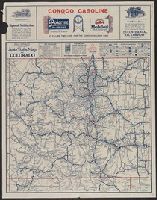
Auto trails map of Colorado, Auto trails map, Denver and vicinity., Official 1924, auto trails map of Colorado, and Rand McNally detailed auto trails map, Denver and vicinity.
Description:
Distributed by the Continental Oil Company., On verso: Rand McNally detailed auto trails map, Denver and vicinity. Scale [ca. 1:500,000]., Relief shown by hachures and spot heights., and Shows trail and highway markings.
Publisher:
Rand McNally & Company,
Subject (Geographic):
Colorado--Maps
Subject (Name):
Continental Oil Company
Subject (Topic):
Roads--Colorado--Denver Region--Maps and Roads--Colorado--Maps
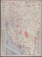
"Rand McNally road map, United States" (scale [ca. 1:10,200,960], 1 in. = approx. 161 miles), text, and distance table on verso., Copyright: Rand McNally & Company., In lower right: 1-463629V-7., Includes mileage chart and index., and Relief shown pictorially and by spot heights.
Publisher:
The Company,
Subject (Geographic):
California--Maps
Subject (Name):
Randall Motor Club
Subject (Topic):
Roads--California--Maps and Roads--United States--Maps
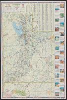
"Prepared for Standard Oil Company of California.", In lower left: 11-HH-286-S., Includes index to cities and towns, and ill. index of points of interest., Mileage chart and 4 ancillary maps on verso., and Relief shown by hachures and spot heights.
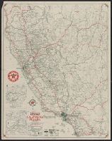
1931 Texaco road map, California, Nevada, Road map, California, Nevada, and Texaco road map, 1931, United States.
Description:
At head of title: 1931., Index, ill., and road maps of United States, Oakland area, Los Angeles and vicinity, and San Francisco area on verso., Insets: Map of Yosemite National Park -- Map of Sequoia & Gen. Grant national parks., and Relief shown by hachures and spot heights.
Publisher:
Rand McNally,
Subject (Geographic):
California--Maps and Nevada--Maps
Subject (Name):
Texas Company
Subject (Topic):
Roads--California--Maps, Roads--Nevada--Maps, and Roads--United States--Maps
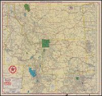
Idaho, Montana, Wyoming, and North & South Dakota, Texaco road map, Idaho, Montana, Wyoming., and Texaco road map, North Dakota, South Dakota.
Description:
"S.2721.", "S.3227.", Includes indexes, text, ill., and maps of "Yellowstone National Park" and "Waterton-Glacier International Peace Park.", Panel title., Relief shown by hachures and spot heights., and Texaco road map, Idaho, Montana, Wyoming -- Texaco road map, North Dakota, South Dakota.
New commercial atlas map of Utah and Utah automobile road map.
Description:
"Utah automobile road map" (scale [ca. 1:965,485]) and advertisement on verso., In lower right margin: 253c., Indexed., Relief shown by hachures., and Shows railroads and counties.