Skip to search
Skip to main content
Skip to first result
Search
You Searched For
Genre
Maps
Creator
Geographical Publishing Co
Publication Place
Chicago :
New Search
Search Results
Creator:
Published / Created:
[1916], c1915.
Call Number:
787 1915
Container / Volume:
BRBL_00517
Image Count:
2
Resource Type:
Maps, Atlases & Globes
Description:
Includes inset map showing congressional districts, rainfall, and soil types., Indexed "Gazetteer of Georgia" on verso., and Shows roads, agricultural schools and experiment stations, counties, and congressional districts.
Publisher:
Geographical Pub. Co.,
Subject (Geographic):
Georgia--Maps
Subject (Name):
Georgia. Dept. of Agriculture
Subject (Topic):
Roads--Georgia--Maps
Found in:
Beinecke Rare Book and Manuscript Library > Official map of Georgia / issued by Department of Agriculture, 1916 ; J.D. Price, Commissioner.
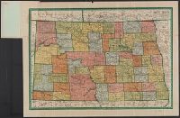
Creator:
Published / Created:
1911
Call Number:
822 1911A
Container / Volume:
BRBL_00567
Image Count:
2
Resource Type:
Maps, Atlases & Globes
Alternative Title:
Complete map of N. Dakota, showing principal automobile roads, electric lines, railroads, M.O. postoffices, banks, rivers, canals, and last U.S. census of all towns and North Dakota
Description:
1910 census gazetteer of North Dakota on verso. and Relief shown by hachures.
Publisher:
Geographical Publishing Co.,
Subject (Geographic):
North Dakota--Maps
Found in:
Beinecke Rare Book and Manuscript Library > Premier series North Dakota / edited, engraved, and published by The Geographical Publishing Co.
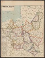
Creator:
Published / Created:
c1923.
Call Number:
356 1923
Container / Volume:
BRBL_00114
Image Count:
1
Resource Type:
Maps, Atlases & Globes
Description:
"Made in USA.", Sep. into two sheets., and Text: "Podział Administracyjny Rzeczypospolitej Polskiej na Województwa i Powiaty."
Publisher:
Geographical Pub. Co.,
Subject (Geographic):
Poland--Administrative and political divisions--Maps
Found in:
Beinecke Rare Book and Manuscript Library > Rzeczpospolita Polska : w granicach obecnych z Podziałem na Województwa i z Wyszczególnieniem Wszystkich miast Powiatowych.
Creator:
Published / Created:
1918
Call Number:
11hc 1918A
Container / Volume:
BRBL_00010E
Image Count:
2
Resource Type:
Maps, Atlases & Globes
Alternative Title:
Liberty war map, Red white and blue, and Red white and blue.
Description:
Ancillary maps: Italian front -- Eurasia. and Index on verso.
Publisher:
Geographical Pub. Co.,
Subject (Geographic):
Eurasia--Maps
Subject (Topic):
World War, 1914-1918--Campaigns--Western Front--Maps and World War, 1914-1918--Europe--Maps
Found in:
Beinecke Rare Book and Manuscript Library > Western battle front showing the fighting fronts of the United States Army and her allies [cartographic material] : from London, England to Basel, Switzerland / Geographical Publishing Co.
Branch:v1.61.8 ,Deployed:2024-06-20T11:15:02-04:00