Skip to search
Skip to main content
Skip to first result
Search
You Searched For
Genre
Manuscript maps
Resource Type
Maps, Atlases & Globes
Language
English
New Search
Search Results
Published / Created:
[between 1875 and 1900?]
Call Number:
BrSides 2018 155
Image Count:
1
Resource Type:
Maps, Atlases & Globes
Description:
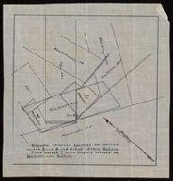
"Magnolia adversed Ypsilanti on conflicts marked A and B, and did not adverse Bullion. Piece marked C is in dispute between the Ypsilanti and Bullion.", From the Richard H. Rickard Papers., and Title devised by cataloger.
Subject (Name):
Rickard, Richard H.,---1885--Ownership.
Subject (Topic):
Copper mines and mining--Michigan--Maps.
Found in:
Beinecke Rare Book and Manuscript Library > [Manuscript map of mine locations in Michigan].
Published / Created:
[between 1875 and 1900?]
Call Number:
BrSides Box 2018 74
Image Count:
1
Resource Type:
Maps, Atlases & Globes
Description:
From the Richard H. Rickard Papers. and Title devised by cataloger.
Subject (Name):
Rickard, Richard H.,---1885--Ownership.
Subject (Topic):
Copper mines and mining--Michigan--Ontonagon County--Maps.
Found in:
Beinecke Rare Book and Manuscript Library > [Manuscript map of mine locations in the vicinity of Mass City, Michigan].
Published / Created:
1824
Call Number:
761 B41 1824
Container / Volume:
BRBL_00710
Image Count:
3
Resource Type:
Maps, Atlases & Globes
Description:
Color: pen and ink.
Subject (Geographic):
Belfast (Me.)--Maps, Manuscript
Found in:
Beinecke Rare Book and Manuscript Library > [Manuscript map of part of Belfast, Maine by George Watson].
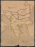
Published / Created:
1919?]
Call Number:
11hcf 1919C-1-3
Container / Volume:
BRBL_00010S
Image Count:
1
Resource Type:
Maps, Atlases & Globes
Description:
Map includes historical regions of Eastern Roumelia, Dobruja, and Bessarabia. Borders drawn in black ink, countries outlined in crayon. and Title supplied by cataloger.
Publisher:
s.n.,
Subject (Geographic):
Balkan Peninsula--Maps and Europe, Eastern--Maps
Subject (Topic):
Boundaries--Balkan Peninsula--Maps and Boundaries--Europe, Eastern--Maps
Found in:
Beinecke Rare Book and Manuscript Library > [Manuscript map of the Balkan Peninsula].
Published / Created:
[1745]
Call Number:
732cea C16 1745
Container / Volume:
BRBL_00709
Image Count:
1
Resource Type:
Maps, Atlases & Globes
Description:
Color: pen and ink drawing.
Subject (Geographic):
Nova Scotia--Maps, Manuscript--Early works to 1800
Found in:
Beinecke Rare Book and Manuscript Library > [Manuscript map of the Gut of Canse].
Published / Created:
[1700?]
Call Number:
761 1700
Container / Volume:
BRBL_00709
Image Count:
1
Resource Type:
Maps, Atlases & Globes
Description:
Color: Pen and ink.
Subject (Geographic):
Maine--Maps, Manuscript--Early works to 1800
Found in:
Beinecke Rare Book and Manuscript Library > [Manuscript map of the Maine Coastline].
Published / Created:
[1690?]
Call Number:
521 J565 1690
Container / Volume:
BRBL_00707
Image Count:
1
Resource Type:
Maps, Atlases & Globes
Description:
Color: Pen and ink drawing. and The map can only be definitely dated between the travels of Henry Middleton in 1608 and James Bruce in 1769. It is probably from around the 1690's or earlier because of the activity of the British East India Co. in this area at that time.
Subject (Geographic):
Jiddah (Saudi Arabia)--Maps, Manuscript--Early works to 1800
Found in:
Beinecke Rare Book and Manuscript Library > [Manuscript map of the Red Sea around the town of Jiddah (or Jedda.)].
Published / Created:
1764
Call Number:
764 1764
Container / Volume:
BRBL_00710
Image Count:
1
Resource Type:
Maps, Atlases & Globes
Description:
Color: pen drawing.
Subject (Geographic):
Massachusetts--Maps, Manuscript--Early works to 1800
Found in:
Beinecke Rare Book and Manuscript Library > [Manuscript map of the Western boundaries of Massachusetts] sworn this line has bin measured this year 1764 ... a true copy N. Dwight. Saml. Messinger surveyor.
Published / Created:
[after 1842]
Call Number:
BrSides Elephant Folio 2018 19
Image Count:
1
Resource Type:
Maps, Atlases & Globes
Description:
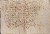
Coordinates not present on map and are approximated., Imperfect: mutilated., Relief shown by hachures., Shows government surveys with landowner and property boundaries drawn in., and Title devised by cataloger.
Subject (Geographic):
Maine--Maps
Subject (Topic):
Real property--Maine--Maps.
Found in:
Beinecke Rare Book and Manuscript Library > [Manuscript map of the northern third of Maine].
Published / Created:
[1846?]
Call Number:
54635 K836 1846
Container / Volume:
BRBL_00707
Image Count:
1
Resource Type:
Maps, Atlases & Globes
Description:
Color: pen and ink.
Subject (Geographic):
Kamchatskai︠a︡ oblastʹ (Russia)--Maps, Manuscript
Found in:
Beinecke Rare Book and Manuscript Library > [Manuscript map showing part of the Bering Island or Komandor Islands and the position of the wreck of the ship "Baltic" out of New Bedford].
Branch:v1.61.8 ,Deployed:2024-06-20T11:14:46-04:00