Hand colored., Relief shown pictorially., Shows "West longitude from London" and "from Philadelphia.", and Single sheet, uncolored, mounted on linen. Dimensions: 48 x 65 cm. Recto: Stamped "Yale Horace Brown 1900S".
Publisher:
Sold by T. Jefferys,
Subject (Geographic):
North America--Maps--Early works to 1800 and Northeastern States--Maps--Early works to 1800
Subject (Name):
Evans, Lewis, 1700?-1756, Jefferys, Thomas, d. 1771, and Mellon, Paul--Bookplate
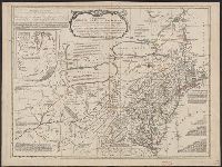
Differs from other copies in absence of Connecticut River north of "Great Falls." Also differs in coloration of boundaries: Ohio and Kentucky Rivers are colored as boundaries; Pennsylvania extends north to a line at approximately 42⁰ 40ʹ; Maryland extends
"The seat of the war in the middle British colonies, containing Virginia, Maryland, the Delaware counties, &ca.", From the author's The American military pocket atlas. [1776], Hand colored., Inset: A sketch of the upper parts of Canada., and Relief shown pictoria
Publisher:
Printed for R. Sayer & J. Bennett, map, chart & printsellers,
"Longit. west from Ferro I.", "Printed for John Bowles at the Black Horse in Cornhill & Carington Bowles in St. Pauls Church yard, London.", and Differs from other copy in coloration. Only boundaries are colored, emphasis is on showing the internal boundaries o
Publisher:
Printed for John Bowles,
Subject (Geographic):
North America--Maps--Early works to 1800
Subject (Name):
Bowles, Carington, 1724-1793, Bowles, John, 1701-1779, and Palairet, Jean, 1697-1774
"Longitude west from London.", First impression of 3d ed., Includes text and inset "A new map of Hudson's Bay and Labrador from the late surveys of those coasts.", and Relief shown pictorially.
Publisher:
Printed for Jefferys and Faden, geographers to the King,
Subject (Geographic):
North America--Maps--Early works to 1800
Subject (Name):
Jefferys and Faden, London and Kitchin, Thomas, d. 1784
Fourth ed., In bottom margin: Publish'd by the author Febry 13th 1755 according to act of Parliament., Includes text and inset "A new map of Hudson's Bay and Labrador from the late surveys of those coasts.", Relief shown pictorially., and Yale's copy stamped on b
Publisher:
Printed for Jefferys and Faden, geographers to the King,
Subject (Geographic):
North America--Maps--Early works to 1800
Subject (Name):
Jefferys and Faden, London and Kitchin, Thomas, d. 1784
"Sold by Wm. Herbert on London Bridge & Robt. Sayer over against Fetter Lane in Fleet Street.", Includes inset showing North America from Hudson's Bay to Panama., Library copy shows damage in top and bottom margins., and Relief shown pictorially.
Publisher:
Sold by Wm. Herbert ...,
Subject (Geographic):
North America--Maps--Early works to 1800
Subject (Name):
Sayer, Robert, 1725-1794 and Society of Anti-Gallicans
Includes historical notes, insets of "A particular map of Baffin and Hudson's Bay" and "The passage by land to California," and articles 4-7, 9, 12, 13, and 20 of the "definitive treaty.", Prime meridian: London and Ferro., Relief shown pictorially., and Stamped
Date in printer statement, in lower right margin: 15th July 1779., Includes notes and insets of "A particular map of Baffin and Hudson's Bay" and "The passage by land to California ....", Prime meridian: London and Ferro., and Relief shown pictorially.
Insets: A particular map of Baffin and Hudson's Bay -- The passage by land to California., Prime meridians: London and Ferro., Relief shown pictorially., and Yale's copy 1 joined on 2 sheets, 54 x 121 cm. and 54 x 120 cm.; coloring differs from copy 2; and stamp
Publisher:
Published by Laurie & Whittle, No. 53 Fleet Street,