Skip to search
Skip to main content
Skip to first result
Search
You Searched For
Resource Type
Maps, Atlases & Globes
Language
Latin
Publication Place
Amsterdami :
New Search
Search Results
Published / Created:
[1635?]
Call Number:
3371 1635
Container / Volume:
BRBL_00089
Image Count:
2
Resource Type:
Maps, Atlases & Globes
Description:
Preliminary record. and Verso: Text.
Publisher:
G. et J. Blaeu,
Subject (Geographic):
Hainaut (Belgium)--Maps--Early works to 1800
Found in:
Beinecke Rare Book and Manuscript Library > Comitatuum Hannoniae et Namusci descriptio.
Published / Created:
[1625?]
Call Number:
3829 1645
Container / Volume:
BRBL_00177
Image Count:
2
Resource Type:
Maps, Atlases & Globes
Description:
Verso: Text.
Publisher:
Guiljelmum et Joannem Blaeuw,
Subject (Geographic):
Aisne (France)--Maps--Early works to 1800
Found in:
Beinecke Rare Book and Manuscript Library > Descriptio Veromanduorum Auctore Joanne Suthonio Gallice Vermandois. Gouvernement de la Cappelle par P. Petit Bourbon.
Published / Created:
[1630?]
Call Number:
3836 1630
Container / Volume:
BRBL_00178
Image Count:
2
Resource Type:
Maps, Atlases & Globes
Description:
Verso: Text.
Publisher:
G. & J. Blaeuw,
Subject (Geographic):
Marne (France)--Maps--Early works to 1800
Found in:
Beinecke Rare Book and Manuscript Library > Dioecese de Rheims, et le Pais de Rethel Par Jean Jubrien ...
Published / Created:
[1630?]
Call Number:
3872 1630
Image Count:
2
Resource Type:
Maps, Atlases & Globes
Description:
Verso: Text.
Publisher:
G. Bleau,
Subject (Geographic):
Périgord (France)--Maps--Early works to 1800
Found in:
Beinecke Rare Book and Manuscript Library > Dioecesis Sarlatensis Vernacule le Dioecese de Sarlat. Joannes Tardo ...
Published / Created:
[1635?]
Call Number:
3364 L62 1635
Container / Volume:
BRBL_00089
Image Count:
1
Resource Type:
Maps, Atlases & Globes
Description:
Preliminary record. and Verso: Text.
Publisher:
G. et J. Blaeu,
Subject (Geographic):
Liége (Belgium)--Maps--Early works to 1800
Found in:
Beinecke Rare Book and Manuscript Library > Ducatus Limburgum Auctore Aegidio Martini.
Published / Created:
[1650?]
Call Number:
3854 1650
Container / Volume:
BRBL_00180
Image Count:
2
Resource Type:
Maps, Atlases & Globes
Description:
Preliminary record. and Verso: Text.
Publisher:
G. et J. Blaeuw,
Subject (Geographic):
Touraine (France)--Maps--Early works to 1800
Found in:
Beinecke Rare Book and Manuscript Library > Ducatus Turonensis ... Touraine.
Published / Created:
[1650?]
Call Number:
3816 1650
Container / Volume:
BRBL_00174
Image Count:
1
Resource Type:
Maps, Atlases & Globes
Description:
Verso: Text.
Publisher:
G. Blaeuw,
Subject (Geographic):
Anjou (France)--Maps--Early works to 1800
Found in:
Beinecke Rare Book and Manuscript Library > Ducatus andegauensis, Auctore Licimo Guyeto Andegavense. Anjow.
Published / Created:
[1635?]
Call Number:
3361 1635
Container / Volume:
BRBL_00088
Image Count:
2
Resource Type:
Maps, Atlases & Globes
Description:
Preliminary record. and Verso: Text.
Publisher:
G. et J. Blaeuw,
Subject (Geographic):
West Flanders (Belgium)--Maps--Early works to 1800
Found in:
Beinecke Rare Book and Manuscript Library > Flandriae Tentonicae pars Orientalior.
Published / Created:
[1650?]
Call Number:
3361 B833 1650
Container / Volume:
BRBL_00088
Image Count:
2
Resource Type:
Maps, Atlases & Globes
Description:
Preliminary record. and Verso: Text.
Publisher:
G. et. J. Blaeuw,
Subject (Geographic):
West Flanders (Belgium)--Maps--Early works to 1800
Found in:
Beinecke Rare Book and Manuscript Library > Franconatus Vulgo Het Vrye.
Creator:
Published / Created:
[163-?]
Call Number:
1973 Folio 18
Image Count:
1
Resource Type:
Maps, Atlases & Globes
Alternative Title:
Gastinois et Hvrepois
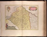
Description:
Backed with paper. Ms. no. "54" in upper-right corner. Sheet measures 53.7 x 63.1 cm. No. 49 of 87 maps bound together., Bar scale given in "milliaria Gallica"., Decorative title cartouche in upper right, coat of arms in upper left, and bar scale cartouche with one figure at the left side, with books and sun, in lower left corner., Prime meridian: Ferro., Relief shown pictorially., Verso blank., Watermark below title cartouche., and Watermark.
Publisher:
Excud. Guiljelmus Blaeu,
Subject (Geographic):
Burgundy (France)--Maps--Early works to 1800., Centre (France)--Maps--Early works to 1800., and Île-de-France (France)--Maps--Early works to 1800.
Found in:
Beinecke Rare Book and Manuscript Library > Gastinois et Hurepois [cartographic material].
Branch:v1.61.6 ,Deployed:2024-06-12T09:55:36-04:00